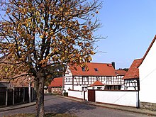
Kaja (Lützen)
Kaja is a village belonging to the Großgörschen district of the city of Lützen in the Burgenland district in Saxony-Anhalt .
geography
Kaja is located southeast of Lützen between Leipzig and Weißenfels , and between the opencast mining areas of Zwenkau and Profen . The village is surrounded by extensive agricultural land. Kaja is north of Rahna , west of Kleingörschen and northwest of Großgörschen. The raft ditch flows through the village and the L 184 runs through the village.
The A 38 passes north of Kaja .
history
Kaja is a Slavic foundation from around the year 600. The oldest documented mention goes back to 1277 . At that time, the Wettin Margrave Dietrich von Landsberg sold the Eisdorf court seat, including all the associated locations, to the bishop of the Merseburg Monastery Friedrich I von Torgau for 300 silver marks . Kaja is also mentioned among the thirty places.
In 1713 the entire village hall of Kaja was measured and mapped. The corresponding land register is still available.
The battle of Großgörschen took place in 1813 mainly in Kaja and the surrounding area.
In the period that followed, Kaja belonged to the Hochstift-Merseburg office of Lützen until 1815 , which has been under the Saxon buw since 1561 . from 1806 it was under royal Saxon sovereignty and between 1656/57 and 1738 it belonged to the secondary school principality of Saxony-Merseburg .
In the course of the first district reform in the GDR , Kaja was incorporated into Großgörschen on July 1, 1950 and reclassified into the Weißenfels district . Großgörschen has been part of the new town of Lützen since 2010.
Web links
Individual evidence
- ^ Community Großgörschen - general information. Archived from the original on June 18, 2009 ; accessed on July 4, 2018 .
- ^ In the state archive of Saxony-Anhalt in the official inventory of Lützen (D 25).
- ^ Karlheinz Blaschke , Uwe Ulrich Jäschke : Kursächsischer Ämteratlas , Leipzig 2009, ISBN 978-3-937386-14-0 , p. 84 f.
- ↑ Großgörschen and its districts in the historical directory of the association for computer genealogy
- ↑ StBA: Area changes from January 01 to December 31, 2010
Coordinates: 51 ° 14 ' N , 12 ° 10' E

