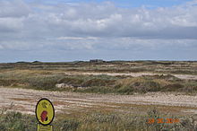
Kallesmærsk Hede
The Kallesmærsk Hede is a Natura 2000 protected area in the south of Denmark. The area lies between the resorts of Vejers Strand and Blåvand . Parts of the area are used as a military training area at Oksbøl Skyde- og Øvelsesterræn .
The protected area covers a total area of 11,636 hectares . It is divided into three sub-areas: Kallesmærsk Hede og Grærup Langsø (6,570 ha), Filsø (4,270 ha) and Kærgård Klitplantage (796 ha). The total area is designated as a fauna-flora-habitat area, the sub-areas Kallesmærsk Hede og Grærup Langsø and Filsø as bird sanctuaries ; the Filsø sub-area is also protected under the Ramsar Convention .
A troop training and firing range was set up in the heath as early as 1929. Its area covers 6,500 hectares, for which 60 farms, 42 residential buildings and 116 holiday homes were expropriated and added to the military area. Because of the military use, the heather areas are kept open, no maneuvers take place during the bird breeding and resting time.
Habitat types
The following “habitat types of community interest” are located in the FFH area; priority habitat types are marked with *.
| Natura 2000 code | Habitat type | size |
|---|---|---|
| 2110 | Primary dunes | 3.2 ha |
| 2120 | White dunes with beach grass Ammophila arenaria | 140.0 ha |
| 2130 | * Fixed coastal dunes with herbaceous vegetation (gray dunes) | 960.0 ha |
| 2140 | * Decalcified dunes with Empetrum nigrum | 2429.0 ha |
| 2160 | Dunes with Hippophaë rhamnoides | 11.0 ha |
| 2170 | Dunes with Salix repens ssp. argentea ( Salicion arenariae ) | 24.0 ha |
| 2180 | Forested dunes of the Atlantic, Continental and Boreal regions | ? |
| 2190 | Moist dune valleys | 643.0 ha |
| 2250 | * Mediterranean coastal dunes with juniper Juniperus spp. | 0.6 ha |
| 3110 | Oligotrophic, very weakly mineral waters of the sand plains ( Littorelletalia uniflorae ) | 24.0 ha |
| 3130 | Oligo- to mesotrophic standing water with vegetation of the Littorelletea uniflorae and / or the Isoëto-Nanojuncetea | - |
| 3150 | Natural eutrophic lakes with magnopotamion or hydrocharition vegetation | 30.0 ha |
| 3260 | Rivers of the planar to montane level with vegetation of the Ranunculion fluitantis and the Callitricho-Batrachion | 51.0 km |
| 4010 | Moist heaths of the North Atlantic with Erica tetralix | 15.0 ha |
| 4030 | Dry European heaths | 37.0 ha |
| 5130 | Formations of Juniperus communis on limestone heaths and lawns | ? |
| 6410 | Pipe grass meadows on lime-rich soil, peaty and clayey-silty soils ( Molinion caeruleae ) | 55.0 ha |
| 6430 | Moist tall herbaceous vegetation of the planar and montane to alpine level | - |
| 7140 | Transitional and vibrating turf moore | 2.4 ha |
| 7150 | Peat Bog Schlenken ( Rhynchosporion ) | 14.0 ha |
| 7230 | Lime-rich fens | 3.6 ha |
| 91D0 | * Bog forests | ? |
| 91E0 | * Alluvial forests with Alnus glutinosa and Fraxinus excelsior ( Alno-Padion , Alnion incanae , Salicion albae ) | ? |
fauna
In addition to otters and red deer populations, there are numerous bird species in the protected area:
- Wood sandpiper (breeding bird)
- Woodlark (breeding bird)
- Red-backed Red-backed Bird
- Bittern (breeding bird)
- Marsh harrier (breeding bird)
- Spotted Moorhen (breeding bird)
- Montagu's Harrier (breeding bird)
- Goat milker (breeding bird)
- Greylag goose (migratory bird)
- Short-billed goose (migratory bird)
- Mornellregenpfeifer (migratory bird)
- Whooper swan (migratory bird)
- Pintail (migratory bird)
- Miniature swan (migratory bird)
During the migration period between 15,000 and 20,000 gray geese and between 5,000 and 10,000 short-billed geese stay in the area, plus around 1,000 swans.
The red deer populations in the heathland are the largest in Denmark.
Others
In the southeast of the protected area, in Husbjerg Klit in Oksby Plantage, six Danish resistance fighters were buried in December 1943, who had previously been executed by the German occupiers near or in Aarhus . After the end of the war, the corpses could be exhumed. In 1952 a memorial stone was erected at this point.
Eight barrows and numerous - albeit invisible - prehistoric dwellings are scattered across the Kallesmærsk Hede .
Web links
- BirdLife IBA factsheet
- Maneuver times Oksbøllejren Official website (German, English, Danish)
literature
- Information sheet from the military leadership (Forsvaret), Oksbøl 2014
Individual evidence
- ↑ a b c basic analysis 2006. Habitatområde no. 73, Fuglebeskyttelsesområde no. 50 and 56 (Ramsarområde nr. 1). (PDF) Ribe Amt, p. 7 , accessed on July 22, 2015 (Danish).
- ↑ Hemmelige grave i Husbjerg Klit ved Oksbøl airmen.dk, accessed on November 16, 2016 (PDF, Danish).
Coordinates: 55 ° 35 ′ 0.2 ″ N , 8 ° 10 ′ 0 ″ E


