Kameni Chora
|
Kameni Chora Καμένη Χώρα |
||
|---|---|---|
|
|
||
| Basic data | ||
| Country |
|
|
| region | Attica | |
| Regional district | Islands | |
| local community | Trizinia-Methana | |
| Parish | Methana | |
| Local community | Megalochori | |
| Geographic coordinates | 37 ° 37 ′ N , 23 ° 20 ′ E | |
| Height above d. M. |
412 m |
|
| Residents | 21 (2011) | |
| LAU-1 code no. | 5208020403 | |
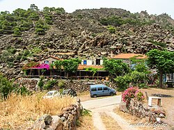
| “Ifestio” tavern in Kameni Chora | ||
Kameni Chora ( Greek Καμένη Χώρα , also Kammeni or Kaimeni (Καημένη) Chora ( f. Sg. ) = Burned land ) is a small village on the northwest half of the Methana peninsula in Greece . It is located in a valley between the Malia Vgethi volcanic peak and the Kameno Vouno volcano, which erupted in historical times . This dominates the landscape today and is one of the most important sights in the Trojan country . He was sometime between 277 BC. BC and 221 BC Chr. Active. Today a road leads to the point from which you can get to the eruptive center of the volcano in about 45 minutes. It is a volcanic dome and therefore has no explosive crater , as it occurs on Stromboli, for example . The tough lava mass built up to a 412 meter high volcanic dome, which consists of andesite and dacite . The volcano was explored and mapped by geologists Washington, Foque, RV Leyden, V. Dietrich and Michalis Fytikas, among others.
The small village of Kameni Chora at the foot of the volcano has a rural character. The farmers live there from growing olives , almonds and wine . In the meantime, tourism is also becoming increasingly important. At the village tavern "Ifestio" ( Greek Ηφαίστειο = volcano ) begins a road that leads to Cape Kalo Koumbaro . There are also numerous points where lava flowed from cracks in the karst mountains and there is another, small eruption center near the Agios Andreas chapel.
About 1.5 km north of the coast there are a number of other submarine volcanoes at a depth of about 100 m. The best known is the Pafsanias , which was active until the 17th century. The region is currently being intensively researched and mapped using an undersea robot.
Web links
literature
Hans-Peter Siebenhaar : Peloponnese: travel guide with many practical tips. , 2012, ISBN 978-3899537147 , p. 343
Individual evidence
- ↑ Results of the 2011 census at the National Statistical Service of Greece (ΕΛ.ΣΤΑΤ) ( Memento from June 27, 2015 in the Internet Archive ) (Excel document, 2.6 MB)

