
Lefktro
|
Lefktro parish Δημοτική Ενότητα Λεύκτρου (Λεύκτρο) |
|||
|---|---|---|---|
|
|||
| Basic data | |||
| State : |
|
||
| Region : |
Peloponnese
|
||
| Regional District : | Messinia | ||
| Municipality : | Dytiki Mani | ||
| Geographic coordinates : | 36 ° 51 ′ N , 22 ° 16 ′ E | ||
| Height above d. M .: | 5 - 10 - 620 m Trachila - Kardamyli - Saidona |
||
| Area : | 222.981 km² | ||
| Residents : | 4,699 (2011) | ||
| Population density : | 21.1 inhabitants / km² | ||
| Code No .: | 440201 | ||
| Structure: | 19 local communities | ||
| Located in the municipality of Dytiki Mani and the Messenia region | |||
 |
|||

Lefktro ( Greek Λεύκτρο ( n. Sg. )) Has been a district of the municipality of Dytiki Mani in the Greek region of Peloponnese since 2011 . It emerged from the community of the same name, which has existed since 1997. The area of the municipality lies in the so-called Outer Mani , the middle finger of the Peloponnese peninsula . The administrative seat was the place Kardamyli.
Administrative division
The municipality is divided into 19 local communities.
| Local community | Greek name | code | Area (km²) | 2001 residents | Residents 2011 | Villages and settlements | location |
|---|---|---|---|---|---|---|---|
| Kardamyli | Τοπική Κοινότητα Καρδαμύλης | 44020101 | 6.427 | 477 | 417 | Kardamyli, Agia Sofia, Kalamitsi, Kambos, Petrovouni, Meropi | 36 ° 53 ′ 12 "N, 22 ° 13 ′ 56" E |
| Agios Nikolaos | Τοπική Κοινότητα Αγίου Νικολάου | 44020102 | 3.051 | 508 | 331 | Agios Nikolaos, Agios Dimitrios | 36 ° 49 ′ 30 "N, 22 ° 16 ′ 54" E |
| Agios Nikonas | Τοπική Κοινότητα Αγίου Νίκωνος | 44020103 | 7.459 | 146 | 79 | Agios Nikonas | 36 ° 45 ′ 5 ″ N, 22 ° 20 ′ 7 ″ E |
| Exochori | Τοπική Κοινότητα Εξωχωρίου | 44020104 | 39.141 | 334 | 359 | Exochori, Stara, Chora | 36 ° 54 ′ 4 ″ N, 22 ° 16 ′ 4 ″ E |
| Thalames | Τοπική Κοινότητα Θαλαμών | 44020105 | 6.002 | 129 | 77 | Thalames, Platanos, Somatiana | 36 ° 47 ′ 4 "N, 22 ° 19 ′ 44" E |
| Karyovouni | Τοπική Κοινότητα Καρυοβουνίου | 44020106 | 14.031 | 82 | 42 | Karyovouni, Dryopi | 36 ° 51 ′ 23 "N, 22 ° 20 ′ 31" E |
| Kastanea | Τοπική Κοινότητα Καστανέας | 44020107 | 9.329 | 203 | 102 | Kastanea | 36 ° 51 ′ 23 "N, 22 ° 20 ′ 31" E |
| Langada | Τοπική Κοινότητα Λαγκάδας | 44020108 | 17,182 | 209 | 111 | Langada | 36 ° 46 ′ 46 "N, 22 ° 20 ′ 27" E |
| Milea | Τοπική Κοινότητα Μηλέας | 44020109 | 34.239 | 366 | 153 | Milea, Kato Chora, Kyvelia | 36 ° 50 ′ 39 "N, 22 ° 21 ′ 27" E |
| Neochori | Τοπική Κοινότητα Νεοχωρίου | 44020110 | 7.533 | 1108 | 1399 | Neochori, Agios Vasilios, Lefktro, Marmoutsa, Stoupa | 36 ° 50 ′ 39 ″ N, 22 ° 17 ′ 10 ″ E |
| Nomitsis | Τοπική Κοινότητα Νομιτσή | 44020111 | 5.027 | 117 | 111 | Nomitsis | 36 ° 47 ′ 34 "N, 22 ° 19 ′ 31" E |
| Platsa | Τοπική Κοινότητα Πλάτσης | 44020112 | 9,829 | 372 | 346 | Platsa, Kotroni, Bazigeika, Pigi, Poliana | 36 ° 48 ′ 17 "N, 22 ° 19 ′ 3" E |
| Proastio | Τοπική Κοινότητα Προαστίου | 44020113 | 9.533 | 432 | 364 | Proastio, Ai Gianna, Lakkos, Neo Proastio, Prastova | 36 ° 52 ′ 38 "N, 22 ° 15 ′ 11" E |
| Prosilio | Τοπική Κοινότητα Προσηλίου | 44020114 | 10,824 | 213 | 171 | Prosilio, Kalives | 36 ° 54 ′ 55 "N, 22 ° 14 ′ 12" E |
| Pyrgos | Τοπική Κοινότητα Πύργου Καλαμών | 44020115 | 4,276 | 185 | 95 | Pyrgos | 36 ° 50 ′ 14 "N, 22 ° 17 ′ 57" E |
| Ringlia | Τοπική Κοινότητα Ριγκλίων | 44020116 | 2,450 | 189 | 214 | Ringlia, Ano Ringlia, Eleochori, Plagiada | 36 ° 49 ′ 25 "N, 22 ° 17 ′ 59" E |
| Saidona | Τοπική Κοινότητα Σαϊδόνας | 44020117 | 7.203 | 123 | 47 | Saidona | 36 ° 52 ′ 54 ″ N, 22 ° 17 ′ 3 ″ E |
| Trachila | Τοπική Κοινότητα Τραχήλας | 44020118 | 2,350 | 174 | 95 | Trachila | 36 ° 46 ′ 17 "N, 22 ° 18 ′ 44" E |
| Tseria | Τοπική Κοινότητα | 44020119 | 27.095 | 191 | 192 | Tseria, Giatraika, Zacharia, Katafygi, Leftini, Pedino | 36 ° 54 '56 "N, 22 ° 16'10" E |
| total | 440201 | 222.981 | 5558 | 4699 | |||
Kardamyli
Kardamyli (also Kardamili, Greek Καρδαμύλη ), located directly on the Messinian Gulf on the Greek peninsula of Mani, was the administrative seat of the municipality of Lefktro until 2010, but with its 500 inhabitants it looks more like a village. But the place is a supply center for the surrounding villages. A number of hotels, pensions and gastronomic establishments offer their services to vacationers. Kardamyli was the residence of former British officer and writer Patrick Leigh Fermor from 1960 until his death in 2011 . In 1989 the ashes of the writer Bruce Chatwin were buried in the hills above the village .
history
Kardamyli is already mentioned in the Iliad by Homer . It was promised by Agamemnon to Achilles as a dowry if he would marry his daughter:
"Ἑπτὰ δὲ οἱ δώσω εὖ ναιόμενα πτολίεθρα / Καρδαμύλην Ἐνόπην τε καὶ Ἱρὴν ποιήεσσαν / Φηράς τε ζαθέας ἠδ 'Ἄνθειαν βαθύλειμον / καλήν τ' Αἴπειαν καὶ Πήδασον ἀμπελόεσσαν"
"I want to give him seven richly populated cities: / Enope, then Kardamyle, and the green Hire, / Pherae, the holy castle, and the meadows of Antheias, / also the beautiful Aipeia and Pedasos' vine hill"
In Roman times, Kardamyli was the port for Sparta and in Byzantine times it was the port of Mystras . During the Turkish rule over Greece, Kardamyli was able to maintain a certain independence thanks to its remote location. Many Byzantines sought refuge here.
Before and during the Greek Wars of Liberation around 1821, Kardamyli was a place of refuge and meeting place for the liberation warriors. From here, on August 22, 1821, Koloktronis and his men set out to liberate Kalamata .
Attractions
- Church of St. Spiridona
- Dioscuri tombs
- Towers and tower houses in Altkardamyli
Altkardamyli consists of four separate fortified properties that form a closed ensemble. The properties had a separate defense tower, tower house, church or chapel, well house and farm buildings. The properties were abandoned and fell into disrepair in the early 20th century. In the meantime, Alt-Kardamyli has been restored and some of it has been made habitable again. A museum has been set up in a Mourtzinoi tower house that shows the history of the Mani and the estate.

View of Kardamyli from the north
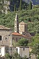
Ag. Spiridon, house church of the Mourtzinoi

Defense tower of the Mourtzinoi

Lagkada locality


See also
Attractions
- Vyrou canyon
- Petrovouni village
- Agia Sofia village
Individual evidence
- ↑ Results of the 2011 census, Greek Statistical Office (ΕΛ.ΣΤΑΤ) ( Memento from June 27, 2015 in the Internet Archive ) (Excel document, 2.6 MB)