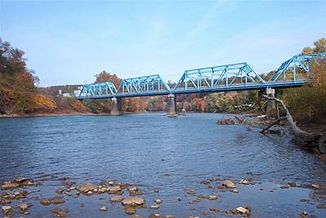
Kiskiminetas River
| Kiskiminetas River | ||
| Data | ||
| Water code | US : 1192712 | |
| location | Pennsylvania ( USA ) | |
| River system | Mississippi River | |
| Drain over | Allegheny → Ohio → Mississippi → Gulf of Mexico | |
| origin | Confluence of Loyalhanna Creek and Conemaugh Rivers at Saltsburg 40 ° 40 ′ 46 ″ N , 79 ° 40 ′ 1 ″ W |
|
| Source height | 252 m | |
| muzzle | at Freeport in the Allegheny River coordinates: 40 ° 29 ′ 8 ″ N , 79 ° 27 ′ 14 ″ W 40 ° 29 ′ 8 ″ N , 79 ° 27 ′ 14 ″ W. |
|
| Mouth height | 227 m | |
| Height difference | 25 m | |
| Bottom slope | 0.58 ‰ | |
| length | 43 km | |
| Catchment area | 4,887.3 km² | |
| Discharge at the Vandergrift A Eo gauge: 4,726.7 km² |
NNQ (1952) MNQ 1942–2017 MQ 1942–2017 Mq 1942–2017 MHQ 1942–2017 HHQ (1942) |
700 l / s 20.9 m³ / s 36.57 m³ / s 7.7 l / (s km²) 57.7 m³ / s 788.69 m³ / s |
| Left tributaries | Loyalhanna Creek | |
| Right tributaries | Conemaugh River , Blacklegs Creek | |
The Kiskiminetas River is a 43-kilometer tributary of the Allegheny River in the southwest of the US state Pennsylvania . It flows through the counties of Westmoreland , Indiana and Armstrong and drains an area of around 4,887 square kilometers.
course
The river is created by the confluence of Loyalhanna Creek and Conemaugh River near Saltsburg . It mostly flows in a northwest direction past Avonmore , Apollo , Oklahoma , Vandergrift , Hyde Park and Leechburg . At Freeport the river finally flows into the Allegheny River. The main tributary is the Blacklegs Creek .
Individual evidence
- ^ Loyalhanna Creek in the Geographic Names Information System of the United States Geological Survey
- ↑ Kiskiminetas River in the Geographic Names Information System of the United States Geological Survey
- ↑ USGS National Map Viewer
- ^ Lycoming College Pennsylvania Gazetter of Streams (PDF)
- ^ Kiskiminetas River at Vandergrift Pennsylvania Water Science Center, United States Geological Survey
