
Kitzbüheler Horn
| Kitzbüheler Horn | ||
|---|---|---|
 Kitzbüheler Horn as seen from Hochgrubachkar |
||
| height | 1996 m above sea level A. | |
| location | Tyrol , Austria | |
| Mountains | Kitzbühel Alps | |
| Dominance | 8.7 km → Wildseeloder | |
| Notch height | 516 m ↓ Scharte to the Stuckkogel | |
| Coordinates | 47 ° 28 '36 " N , 12 ° 25' 51" E | |
|
||
| rock | Spielberg dolomite group | |
| Age of the rock | Lower Devon - Middle Devon | |

The Kitzbüheler Horn is one of the more important mountains in the Kitzbühel Alps in Tyrol , on the eastern flank of which it is located near the municipality of Kitzbühel . With a height of 1996 m above sea level. A. he just misses the two-thousand-meter limit.
At the main summit of the same name there is a 102 m high television tower owned by the Austrian Broadcasting Corporation (ORS), the Kitzbüheler Horn transmission tower . With the Harschbichl ( 1604 m ) there is another subordinate peak that is accessible from the north.
tourism
The mountain is with several cable cars and a toll panorama road accessed from Kitzbuehel, located on a slope several mountain economies. An alpine flower garden has been laid out at an altitude of 1800 m, in which, despite the name, mountain plants from all over the world can be seen.
Sports
summer
The so-called Alpenhaus ( 1670 m above sea level , ⊙ ) has been the destination of the king's stage of the Austria cycle tour in recent years .
The International Kitzbüheler Horn Cycle Race takes place every year in August. The race track leads over the 7.4 km long toll road to the Alpenhaus. The maximum gradient on the final ascent is 22.4%. The record for the Alpenhaus was set in 2007 by Thomas Rohrgger and is 28:24 minutes.
The 37th Kitzbüheler Horn Mountain Road Run took place on August 30th, starting at 9:30 a.m. at the Kitzbüheler Hauptplatz. The 12.9 km long route has gradients of 12 to 16% from km 3.5, the difference in altitude is 1234 meters.
On the side facing St. Johann there is a mountain cart route from Harschbichl into the valley. At the level of the middle station of the St. Johanner Bergbahnen and further east of it and in the Eichenhof area there are mountain lakes as storage for the artificial snow systems. Both peaks are used intensively not only by hikers but also by mountain bikers due to the well-developed paths.
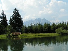
Mountain lake at the middle station with a view of the Wilder Kaiser
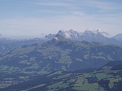
The Kitzbüheler Horn seen from the Gampenkogel, in the background the Loferer Steinberge


winter
Franz Reisch first went down the Kitzbüheler Horn on skis in the spring of 1893.
Winter sports are offered on the north-west slopes of the Kitzbüheler Horn by the St. Johann mountain railways . The Kitzbühel cable cars operate lifts and slopes on the summit and in the southeast . There is no connection between the two ski areas on the mountain.
The Kitzbüheler Bergbahn maintains the following winter sports on the Kitzbüheler Horn:
- Nature and family paradise
- Natural snow slopes
- Family-friendly slopes
- Terrain for beginners
- Horn Mini New School Park
- Backcountry for freeriders
- Natural snow cross-country ski trail on the mountain

Kitzbüheler Horn from the north
View from the Kitzbüheler Horn in northeast direction

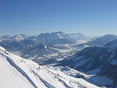
View from the Kitzbüheler Horn in south direction

Black ski slope on the Kitzbüheler Horn, view of the Wilder Kaiser


Individual references and sources
- ↑ - ( Memento of the original from May 5, 2009 in the Internet Archive ) Info: The archive link was inserted automatically and has not yet been checked. Please check the original and archive link according to the instructions and then remove this notice.
- ^ Austrian Map online 1: 50,000 (ÖK 50) of the BEV
- ↑ kitzbühel.com , accessed on October 27, 2011
- ↑ 37th Kitzbüheler Horn mountain road run , accessed on August 30, 2015
- ↑ - ( Memento of the original from December 11, 2011 in the Internet Archive ) Info: The archive link was automatically inserted and not yet checked. Please check the original and archive link according to the instructions and then remove this notice.