Small witch head
| Small witch head | ||
|---|---|---|
|
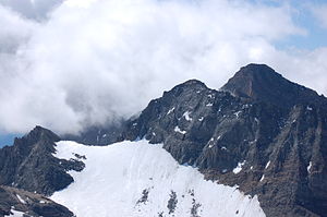
Small (left) and large witch's head (center) seen from the Weißspitze. In between the snow-covered Hexenkopfscharte, behind it the Hohe Eichham. |
||
| height | 3194 m above sea level A. | |
| location | East Tyrol , Austria | |
| Mountains | Venediger group | |
| Dominance | 0.25 km → Großer Hexenkopf | |
| Notch height | 61 m ↓ notch to the Großer Hexenkopf | |
| Coordinates | 47 ° 3 '41 " N , 12 ° 24' 35" E | |
|
|
||
| First ascent | August 13, 1898 by H. v. Ficker and L. Prochaska | |
| Normal way | From the Eisseehütte | |
The Kleine Hexenkopf ( 3194 m above sea level ) is a mountain peak of the Eichhamstock in the Venediger group in East Tyrol ( Austria ). It is located in the west of the municipality of Matrei in East Tyrol , near the municipal boundary to Prägraten am Großvenediger . Neighboring peaks are the Hintere Seekopf in the north and the Große Hexenkopf in the southeast. The first ascent took place on August 13, 1898 by H. v. Ficker and L. Prochaska.
location
The Kleine Hexenkopf, a sharp-edged pyramid, is located in the north of the Eichhamstock in the core zone of the Hohe Tauern National Park . To the east of the valley of is ice sea with the Eisseehütte and Timmeltal , in the north-east the Löbbental with Baden's hut and to the east the Frosnitztal . The Kleine Hexenkopf on the southeast ridge is separated from the Großer Hexenkopf ( 3313 m above sea level ) by the Hexenkopfscharte ( 3144 m above sea level ), with the Garaneberkees in the north reaching up to the ridge. The Garaneberkees extends between the Weißspitze and the Seeköpf up to the Hexenköpf. To the south of the Hexenkopfscharte and the Kleiner Hexenkopf lies the Hexenkees along the southeast ridge and the southeast face. In the north, the Seekopfscharte ( 3050 m above sea level ) separates the Kleine Hexenkopf from the Hinteren Seekopf ( 3234 m above sea level ), with the Malfrosnitzkees also located east of the Seekopfscharte and north of the Kleiner Hexenkopf along its eastern ridge.
Promotion opportunities
The normal route to the Kleine Hexenkopf leads over the Eisseehütte and the Eissee, whereby the ascent then leads pathless to the Seekopfscharte. From the Seekopfscharte the ascent is only around 100 meters in altitude over the glacier to the summit rocks or on the northeast ridge in easy block climbing (difficulty I according to UIAA ), whereby the northeast ridge was also used for the first ascent.
Alternatively, the Kleine Hexenkopf can also be climbed via the east ridge, although this variant was first chosen on August 12, 1920 by W. Gruber and Fritz Malcher. The east ridge has a ridge height of 400 meters, which must be climbed in airy climbing (difficulty II according to UIAA ).
Individual evidence
literature
- Georg Zlöbl: The three thousand meter peaks of East Tyrol in the Hohe Tauern National Park . Verlag Grafik Zloebl, Lienz-Tristach 2007, ISBN 3-200-00428-2 .
- Willi End / Hubert Peterka : Alpine Club Leader Venediger Group ; Bergverlag Rudolf Rother ; 4th edition 1994; ISBN 3-7633-1242-0 .
- Alpine Club Map 1: 25,000, sheet 36, Venediger Group , ISBN 3-928777-49-1 .

