
Small fort Hegelohe
| Small fort Hegelohe (field guard at Wp 14/67) |
|
|---|---|
| limes | ORL - ( RLK ) |
| Route (RLK) | Rhaetian Limes, route 14 |
| Dating (occupancy) | by no later than 260 AD |
| Type | Small fort |
| size | 20.25 (20.20) × 20.15 (20.10) (= approx. 0.04 ha) |
| Construction | stone |
| State of preservation | flat rubble wall |
| place | Titting -Hegelohe |
| Geographical location | 48 ° 58 ′ 32.8 " N , 11 ° 16 ′ 16.7" E |
| height | 518 m above sea level NHN |
| Previous | Small fort Biebig (west) |
| Subsequently | Böhming Castle (southeast) |
| Backwards | Fort Pfünz (backwards, south) |
The fortlet Hegelohe (in the older literature as " picket at Guardsman Wp 14/67 ") is a Roman military camp , the close of the World Heritage Site collected Rätische wall was built and its remains today the southwest of the hamlet Hegelohe, part of Titting , in the district of Eichstätt in Bavaria .
Location and research history

The small facility was built on flat terrain on the eastern edge of the short eastern water valley, right next to the Rhaetian wall that runs almost exactly in a south-easterly direction. From the fort square, not only the valley cut facing north to south, but also the border fortifications that went down and up again could be monitored. In addition, there was visual contact with Wp 14/67, which was only presumed to be in the east, and with Wp 14/66, which remains on the other western side of the valley, and whose remains have been preserved.
Friedrich Winkelmann (1852–1934), a route commissioner for the Reich Limes Commission (RLK), mainly developed the stone walls around the small fort. His first report was in 1895. No more excavations have taken place there since then.
Building history
The almost square, 20.25 (20.20) × 20.15 (20.10) meter facility with right-angled corners has a single 3.25 meter wide inlet in the middle of the east wall. This is flanked by two gate walls that are three meters deep and 1.30 meters wide. In contrast to many other similar small forts, the entrance was not on the opposite side of the Limes, because it ran at a distance of 20 to 26 meters along the north wall. On the inner flanks of the gate cheeks, two 0.25 meter protruding and 0.32 meter wide stone approaches could be observed as structural details, behind which the gate wings were once attached. It was found that the defensive wall, preserved in the best case only two to three stone layers high, was all around 0.80 meters thick. In some places a base protruding 0.10 to 0.15 meters from the surrounding wall could still be found. In the northeast corner, the masonry was designed as an opus spicatum (herringbone pattern). The walls themselves were built of mortar mixed with brick dust. The interior development, which was probably grouped around an inner courtyard in a square open to the gate, will - as has been demonstrated in other small fort sites - have been constructed using wood. Winkelmann could not find a ditch.
In the excavation compendium published by the RLK in 1933 , the Upper Germanic-Raetian Limes of the Roemerreich (ORL), it is reported that only “fragments of the most common kind” and many animal bones came to light . A search cut across the complex did not reveal any further buildings. At the request of the forest owner, the excavators had to fill up the excavation site immediately.
Along with the towers, small forts were one of the main bases of the Roman troops directly behind the Limes. However, their occupation and use are usually unknown.
- Location, findings and reconstruction

Location of the small fort Hegelohe
(right in the picture)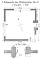
Floor plan of the small fort Hegelohe
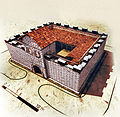
The small fort at the rear of the Schloßbuck, which is obviously very similar


Limes course between the small fort Hegelohe and the fort Böhming
| ORL | Name / place | Description / condition |
|---|---|---|
| KK | Small fort Hegelohe | see above |
| Wp 14/67 | The tower site is only suspected in this area. The thickness of the Limes wall measured between Wp 14/65 and Wp 14/68 was 1.15 and 1.30 meters. To ensure the stability of the wall, the builders fitted them with rectangular wall templates that were 0.25 meters deep and 0.70 meters wide at a distance of 6.90 to 7.30 meters. | |
| Wp 14/68 | "East of Hegelohe" | The 6.10 × 4.00 meter stone tower with its 0.80 meter thick outer walls can be seen preserved. It stands at a slight angle in connection with the subsequently added Limes wall, which is 1.10 meters wide in this area. Since no entrance at ground level could be found on its back, the tower on the first, not preserved floor, had a door that was accessible via a ladder. The mighty, older wooden tower hill to the east with its surrounding rectangular moat is cut through by the wall. The RLK was able to establish the palisade in front of the younger stone wall. The debris wall of the Limes is clearly visible in this area. |
| Wp 14/69 | Tower site is suspected. | |
| Wp 14/70 | "Northeast of Hirnstetten" | The tower was discovered, was difficult to see for Wilhelm Schleiermacher in the 1960s, and Dietwulf Baatz found it to be a very flat tower hill in the 1990s. |
| Wp 14/71 | Tower site is suspected. | |
| Wp 14/72 | "In the Pfahlheg corridor at the height northwest of Pfahldorf" | The tower site built on the Limes wall was found; but the excavation itself is not precisely documented. However, nothing is visible today. |
| Wp 14/73 | Tower site is suspected. In the area of the modern crossing that followed shortly thereafter, the State Office for Monument Preservation discovered parts of the Limes wall and a Roman lime kiln during road construction work in 1981. There is nothing to be seen here today. | |
| Wp 14/74 | Only suspected, archaeologically unproven tower site east of Pfahldorf. Around 150 meters southeast of this point, the Rhaetian Wall in the forest, accompanied by a path, becomes visible as a clear rubble wall. | |
| Wp 14/75 | " East of Pfahldorf " | The remains of Wp 14/75 are visible 50 meters after the start of the rubble wall. The rectangular, 6.60 × 5.80 meter stone tower was built around 25 meters from the Limes wall. It had a ground-level entrance at its rear that was 0.90 meters wide and slightly offset from the center, and had walls between 0.90 and one meter thick. On its eastern outer side, a 0.20 meter wide base reinforcement was found over the entire length. Inside, a fireplace was also found in three corners. Shortly after Wp 14/75, the Limes debris wall makes a slight bend to the southeast. |
| Wp 14/76 | The next watchtower, Wp 14/76, can also only be assumed. It is said to have been on the northern edge of what is now a clearing that is used intensively for agriculture. From here up to Wp 14/77 the limes' debris wall emerges more and more clearly the closer you get into the forest. At Wp 14/76 a post-Roman lime kiln was also found, which was set in the middle of the Limes wall. Here the ancient stone material obtained from the abandoned Limes complex was burned to lime. | |
| Wp 14/77 | " In the Taferlschlag district " |
The remains of the rectangular, 5.95 × 5.20 meter stone tower Wp 14/77, which had 0.50 to 0.65 m thick walls, lie exactly at a bend in the Rhaetian Wall. The Limes wall, 1.2 meters wide at the watchtower, was added later. A screed and fireplaces were found on its floor. At its rear was a 0.90 m wide entrance at ground level, slightly offset from the center. From here to the top of the mountain spur, where the Rhaetian wall naturally ends, and then continues in the valley, the Limes wall can be visited as a mighty dam, only disturbed by old excavation cuts and path cuts.
At the Limeswerk , Winkelmann was already thinking about where the previous building of the stone tower Wp 14/77 might have been. But the location of this wooden tower was only discovered by a close-meshed airborne laser scan in winter / spring 2006/2007. In the digital terrain model, the almost square tower section, which still has a strongly flattened trench around 12 × 12 meters, becomes visible. It is located around 20 meters northeast of the stone tower and is cut in its southern part by the Limes wall. |
| Wp 14/78 | " Pfahlbuck " | In Wp 14/78 the position of the Limes on the mountain spur is particularly clear. The very name of the corridor, Pfahlbuck , makes it clear that knowledge of the pile , as the Limes facilities were often called earlier, was never completely lost in this area. In the north lies the Kälbertal valley; in the south and east the Altmühl flows deep below. In ancient times, you had visual contact with Böhming Castle from here. On the visible older, around 11 × 11 meter large wooden tower hill, the ring trench, which is still around 0.20 to 0.40 meters deep, and the four post holes dug by the RLK that are still around 0.20 meters deep can be recognized. A little to the west of it, again in a Limes bend to the north, there is a 5.50 × 6.50 meter stone tower to which the later built Limes wall was added later. The Kipfenberg Tourist Association equipped the square in 1996 with a rustic “Limes Tower”. The construction of this tourist lookout point does not correspond to the real excavation findings on the Rhaetian Limes. The same applies to the part of the palisade built with the tower. In the course of the expansion to the tourist point, another excavation took place at the tower. Subsequently, a 0.80 meter high partial reconstruction was built on the original foundations and the trees were felled all around. The crossing of the older palisade with the Limes wall has since been visible through the opening of the palisade ditch at the intersection. After this tower, the Limes wall, which now runs in a west-east direction, can be followed a good 53 meters to the end of the mountain spur on a steep slope. Then it breaks off. In the 18th and 19th centuries, however, the building was said to have been traceable further down the slope. In the valley of the Altmühl, the RLK found well-preserved wooden border barriers. |
| ORL 73a | Boehming |


Monument protection
The small fort Hegelohe and the facilities mentioned have been part of the UNESCO World Heritage as a section of the Upper German-Rhaetian Limes since 2005 . In addition, they are protected as registered ground monuments within the meaning of the Bavarian Monument Protection Act (BayDSchG) . Investigations and targeted collection of finds are subject to authorization, accidental finds must be reported to the monument authorities.
See also
literature
- Dietwulf Baatz : The Roman Limes. Archaeological excursions between the Rhine and the Danube . 4th edition, Mann, Berlin 2000, ISBN 3-7861-2347-0 , p. 304.
- Ernst Fabricius , Felix Hettner and Oscar von Sarwey (eds.): The Upper Germanic-Raetian Limes of the Roemerreich , Section A, Volume 7: The routes 14 and 15 . Petters, Heidelberg 1933, p. 106 and plate 11, fig. 1 and 5.
- Thomas Fischer, Erika Riedmeier Fischer: The Roman Limes in Bavaria . Pustet, Regensburg 2008, ISBN 978-3-7917-2120-0
- Christian Fleer: Typification and function of the small buildings on the Limes. In: E. Schallmayer (Ed.): Limes Imperii Romani. Contributions to the specialist colloquium “World Heritage Limes”, November 2001 in Lich-Arnsburg. Bad Homburg v. d. H. 2004, ISBN 3-931267-05-9 , pp. 75-92 (= Saalburg-Schriften 6).
- Günter Ulbert , Thomas Fischer : The Limes in Bavaria . Theiss, Stuttgart 1983, ISBN 3-8062-0351-2
Web links
- The small fort Hegelohe near Arachne , the object database of the University of Cologne and the German Archaeological Institute; Retrieved April 16, 2014.
Remarks
- ↑ a b Ernst Fabricius, Felix Hettner and Oscar von Sarwey (eds.): The Upper Germanic-Raetian Limes of the Roemerreich , Department A, Volume 7: The routes 14 and 15, Petters, Heidelberg 1933, p. 106.
- ↑ ORL = numbering of the Limes structures according to the publication of the Reich Limes Commission on the O bergermanisch- R ätischen- L imes
- ↑ KK = unnumbered K linseed K astell
- ↑ Wp = W oh p east, watch tower. The number before the slash denotes the Limes section, the number after the slash denotes the respective watchtower.
- ↑ Wp 14/67 at about 48 ° 58 '33.46 " N , 11 ° 16' 22.97" O
- ↑ Wp 14/68 (stone tower) at 48 ° 58 ′ 31.03 ″ N , 11 ° 17 ′ 2.48 ″ E
- ↑ Wp 14/68 (wooden tower) at 48 ° 58 ′ 30.94 ″ N , 11 ° 17 ′ 3.46 ″ E
- ↑ Wp 14/69 at approximately 48 ° 58 '27.26 " N , 11 ° 17" 32.9 " E
- ↑ Wp 14/70 at 48 ° 58 '23.08 " N , 11 ° 18' 6.34" O
- ^ Wilhelm Schleiermacher: The Roman Limes in Germany. An archaeological guide for road trips and hikes. Mann, Berlin 1967, p. 196.
- ↑ Dietwulf Baatz: The Roman Limes. Archaeological excursions between the Rhine and the Danube. Mann, Berlin 1993, ISBN 3-7861-1701-2 , p. 304.
- ↑ Wp 14/71 at approximately 48 ° 58 '9.67 " N , 11 ° 18" 48.9 " E
- ↑ Wp 14/72 at 48 ° 57 '57.82 " N , 11 ° 19' 28.84" O
- ↑ Wp 14/73 at approximately 48 ° 57 '49 .83 " N , 11 ° 19' 58.74" E
- ↑ Wp 14/74 at approximately 48 ° 57 '40.63 " N , 11 ° 20' 33.43" O
- ^ A b Günter Ulbert , Thomas Fischer : The Limes in Bavaria. Theiss, Stuttgart 1983, ISBN 3-8062-0351-2 . P. 91.
- ↑ Wp 14/75 at 48 ° 57 '33.76 " N , 11 ° 20' 55.72" O
- ↑ Wp 14/76 at about 48 ° 57 '24.62 " N , 11 ° 21' 22.64" O
- ↑ Wp 14/77 at 48 ° 57 '14.59 " N , 11 ° 21' 48.67" O
- ↑ Hermann Kerscher: Observations at the Limes watch post 14/77 on the Pfahlbuck near Kipfenberg . In: The archaeological year in Bavaria , 2007, Theiss, 2008, pp. 77–78.
- ↑ Wp 14/78 (Steinturm) at 48 ° 57 '3.55 " N , 11 ° 22' 33.31" O ; Wp 14/78 (wood tower) at 48 ° 57 '3.49 " N , 11 ° 22' 34.01" O
- ↑ Hartwig Schmidt : Archaeological Monuments in Germany - Reconstructed and rebuilt. Theiss, Stuttgart 2000, ISBN 3-8062-1395-X , p. 109.
- ↑ Thomas Fischer, Erika Riedmeier Fischer: The Roman Limes in Bavaria . Pustet, Regensburg 2008, ISBN 978-3-7917-2120-0 , p. 135.
- ↑ ORL XY = consecutive numbering of the forts of the ORL
- ↑ Böhming Castle at 48 ° 56 ′ 46 ″ N , 11 ° 21 ′ 39 ″ E

Gunzenhausen Castle | Small fort at the rear Schloßbuck | Theilenhofen Castle (Iciniacum) | Small fort Gündersbach | Ellingen Castle (Sablonetum) | Weissenburg Castle (Biriciana) | Wood-earth fort on the spread in Weißenburg | Oberhochstatt Fort | Burgus Burgsalach | Raitenbuch small fort | Small fort Petersbuch | Small fort Biebig | Small fort Hegelohe | Fort Pfünz (Vetoniania) | Earth fort Nassenfels (Scuttarensium) | Böhming Castle