
Small fort at the rear of the Schloßbuck
| Small fort at the rear of the Schloßbuck | |
|---|---|
| Alternative name | Field watch on the rear Schloßbuck, field watch Schloßbuck |
| limes | ORL –– ( RLK ) |
| Route (RLK) | Rhaetian Limes, route 14 |
| Dating (occupancy) | no later than AD 259/260 |
| Type | Small fort |
| size | approx. 20 × 20 = approx. 0.04 ha |
| Construction | stone |
| State of preservation | clearly visible elevation in a light beech forest |
| place | Gunzenhausen |
| Geographical location | 49 ° 7 '0.6 " N , 10 ° 46' 51.3" E |
| height | 497 m above sea level NHN |
| Previous | Gunzenhausen Fort (west) |
| Subsequently | Small fort Gündersbach (east) |
| Backwards |
Gnotzheim Castle (southwest) Theilenhofen Castle (southeast) |
The small fort on the Hinteren Schloßbuck - also known as Feldwache Schloßbuck and small fort on the Hinteren Schloßbuck - is a small former Roman garrison that was built near the Upper Germanic-Rhaetian Limes , a UNESCO World Heritage Site . His remains are today on the "Schloßbuck", a ridge near Gunzenhausen in the Weißenburg-Gunzenhausen district in Bavaria .
location


The small fort at Hinteren Schloßbuck is located in the middle of the Burgstallwald on the west-east facing 485 meter high Schloßbuck ridge , which rises east of the town of Gunzenhausen. The Gunzenhausen numerus fort was located in Gunzenhausen , which was possibly subordinate to the Gnotzheim cohort fort to the south-west . The Limes watchtower Wp 14/5, which was subsequently built on the Rhaetian wall, is located around 500 meters west of the small fort on the Hinteren Schloßbuck. Before it was built, according to research by the Imperial Limes Commission (RLK), there was a passage through the oak palisade built in the Roman province of Raetia ( Raetia ) around 161 AD, but not through the later stone wall. 165 meters further west of Wp 14/5 was Wp 14/4, almost on the highest point of the ridge. The tower built with the Limes wall probably had a double function. In addition to the guard duty, he was also responsible for the passage through the Limes, which can be verified both in the palisade and in the wall. At a distance of 70 meters from the small fort on the Hinteren Schloßbuck there was Wp 14/6 on the slope sloping to the east and at the bottom of the valley, again 270 meters further, Wp 14/7. The Theilenhofen cohort fort was to the south-east .
Research history
Heinrich Eidam (1849–1934), a route commissioner for the RLK, first cut into small parts of the small fort built around 18 meters behind the Limes wall . Then a memorial stone with the inscription Castrum Romanum was placed on the site of the complex . It was not until late autumn 2009, at the instigation of the Bavarian State Office for the Preservation of Monuments, that research in the form of a magnetometer survey under the direction of geophysicist Jörg Faßbinder took place at the small fort, which was published in 2010.
- Situation situation and attempts at reconstruction

The foundation area of the small fort stands out very clearly in the forest

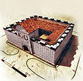
Attempted reconstruction at the fort with the presumed Limes accompanying path in front of it and the Raetian wall
Oblique supervision: According to the magnetometer measurements from 2009, there was apparently no enclosure ditch


Building history

Eidam cut the square, around 20 × 20 meters (= 0.04 hectare) small fort only on the northeast corner. It was found that the camp had a square, 0.70 meter thick, stone set outer wall with right-angled corners. The magnetometer measurements carried out in 2009 confirmed the excavation results determined by Eidam and supplemented the excavation findings. The evaluated data show, among other things, the foundation of the fence, which, according to the measurement data, was between one meter and around 1.20 meters thick. Inside, the measurement image documents around three meters from the surrounding wall, occasionally preserved foundation plinths that are around one meter thick and surround a square inner courtyard. Eidam had already been able to establish this finding. Presumably these bases once carried wooden stands, which possibly supported a pent roof sloping towards the inner courtyard . The interior was divided into living rooms and guard rooms, probably built in wood, around an equally square inner courtyard. During the excavations in Eidam, a three meter wide paving was found between the outer wall and the foundation plinth. The soldiers may have reached a circular walkway through a wooden staircase. Clearly recognizable for the excavators was the rubble, which, like a soldier's primer, could be dated to the first two thirds of the 3rd century. The complex may have perished in the Alemannic Wars, but no later than 260 AD. In front of the small complex, Eidam observed the Limes in its three stages of expansion with woven fence, palisade and stone wall.
A circumferential ditch at this small fort could not be determined by the measurements in 2009, the entrance on the north side facing the Limes could be confirmed.
Along with the towers, small forts were one of the main bases of the Roman troops directly behind the Limes. However, their occupation and use are usually unknown. The massing of towers in the area of the “Schloßbuck” is extraordinary and can possibly only be explained by the Limes passage located there. Why this passage was not laid out on the plain at Gunzenhausen Castle, but on the ridge, which was difficult for travelers, cannot be clarified. The significant reconstruction measures on this section of the Limes are perhaps due to changed requirements.
Limes course between the Hinterer Schloßbuck and Gündersbach
| ORL | Name / place | Description / condition |
|---|---|---|
| KK | Small fort at the rear of the Schloßbuck | see above |
| Wp 14/6 | On the rear Schloßbuck | 70 meters east of the small fort, on the remains of the Limes wall, the enclosure of the 5.4 × 4.4 meter Wp 14/6 is clearly visible. It was also researched by Eidam on behalf of the RLK. This Limes tower was built at the same time as the wall and had a proven ground level access. The older wooden tower hill is 15 meters to the west. On the north side of the hill this is cut by the Limes wall at the edge. Inside were posts and remains of joists. At Wp 14/6 the northernmost point of the Rhaetian Limes is reached. The debris wall of the Limes wall can now be seen for some time in an easterly direction. In older research, the wooden towers are usually referred to as "log houses". |
| Wp 14/7 | On the east side of the rear Schloßbucks | 270 m east of Wp 14/06 nothing can be seen of the stone tower point Wp 14/7. During the excavation by the RLK, the tower was measured with a size of 3 × 4.25 meters. |
| Wp 14/8 | Southwest of Frickenfelden | This 7.9 × 2.4 meter stone tower is also no longer visible. During the excavation, an exceptional structure for the entire Limes was uncovered. The tower (long rectangle with side wings) obviously had additional rooms on the sides, the function of which is unclear. The Rhaetian Wall is in varying degrees of preservation from this tower. |
| Wp 14/9 | Tower site is suspected. | |
| Wp 14/10 | West of Gundelshalm | This stone tower built on the Limes wall was 4.8 × 3.2 meters in size when it was excavated. A step was revealed at its rear. There was probably a level access from which one could get to the basement. There is nothing to be seen there today. |
| Wp 14/11 | The stone tower in Gundelshalm is no longer visible. As the classical philologist Wilhelm Schleiermacher reported in the 1960s, the tower at the western exit of the village was, according to the residents, a victim of stone robbery long ago. In the rising terrain to the east of the tower - behind the village of Gundelshalm - the rubble wall of the Rhaetian Wall becomes visible. | |
| Wp 14/12 | On the Gundelshalmer Buck | When it was excavated, a 6 × 4.5 m foundation was found on the stone tower. On the west side of the building there was a paved passage in the Rhaetian Wall for small border traffic. A statuette of the god Mercury , who is responsible for trade among other things, discovered in the tower area - today in the Gunzenhausen Archaeological Museum - could be connected to the border crossing. The palisade and wicker fence were also interrupted in this area. To the west stood the wooden tower on which apparently no ditch could be found at the time of the RLK. From Wp 14/12, the crew had the best view of the Theilenhofen fort. There is nothing to be seen here today. |
| Wp 14/13 | North of Pfofeld | The Imperial Limes Commission found only rudimentary remains of the stone tower, which was 4.5 meters wide, at this place. The excavators also found that the older palisade and the wicker fence had stood 60 meters in front of the younger stone wall at this point. There is nothing to be seen there today. |
| Wp 14/14 | On the Langlauer Buck | The wooden tower was only cut into by the RLK. To the northeast, in a slight bend in the Limes, was a 4.35 × 3.6 meter stone tower. The older palisade and the wattle fence could again be found in front of the stone wall. Today almost nothing can be seen there. |
| Wp 14/15 | Use on the Pfofelder | Wp 14/15 was built at the highest point of a hill. The RLK uncovered a well-preserved wooden tower with a moat. To the north-west of this building, the stone tower was discovered with a floor plan of 5.5 × 5.1 meters. In addition to traces of palisade and braided fence, the RLK determined that the stone wall should have intersected an older paved road at this point. There is nothing to be seen there today. The rubble of the Limes Wall, on the other hand, is clearly visible in the terrain. |
| Wp 14/16 | Tower site is suspected. | |
| Wp 14/17 | On the Ritterner Espan |
The 4.5 × 4.35 meter stone tower foundation, which was built in a slight bend in the wall, has been restored. Until the land consolidation in 1969/1970, the Limes wall, which belonged to the then restored tower foundation, was still visible as a wide strip of wasteland. Since intensive sheep breeding was given up at that time, there was a risk of weed infestation at this landmark. Therefore, this was replaced by the path visible today as part of the land consolidation. From the tower at the same height you have an excellent view. To the west of the stone tower, the wooden tower was excavated, inside of which a beam grate was found, as it was typical for the base of the wooden towers.
Both the stone wall and the wattle fence cut the wooden tower there.
|
| Wp 14/18 | In Herrlesloh |
Tower site barely visible. A stone tower measuring 4.6 × 4.6 m was uncovered during the excavations. The Limes wall cut through the older wooden tower. |
| Wp 14/19 | At the summer management | This stone watchtower was located at a sharp bend in the Limes wall to the northeast. All traces above ground have disappeared. |
| Wp 14/20 | On the southern slope of the mistletoe mountain | During the excavation by the RLK, a 5.4 × 6.4 meter stone tower foundation was found. The tower was restored and the base was bricked up. The Limes wall was subsequently placed against the tower and makes a slight bend to the northeast there. It cannot be seen in this area. |
| Wp 14/21 | In the Lehmacker northeast of Dorsbrunn | The tower point is not visible. During the excavation, a 5.1 × 4.3 meter stone tower foundation was found. |
| Wp 14/22 | At the Pfahlrain southwest of Walkerszell | The tower point is not visible. During the excavation, a 5.2 × 4.7 meter stone tower foundation was found. The wooden tower was also uncovered. In addition to the palisade and wattle fence, a passage was found in the Limes wall. |
| Wp 14/23 | Due to the average distance between watchtowers and numerous surface finds, suspected but not archaeologically proven tower site. | |
| Wp 14/24 | Southwest of Gündersbach | In this area the debris wall of the Limes wall is clearly visible. On the floor of the stone tower with a footprint of 6 × 4.55 meters, the excavators discovered a stone hand mill used by the Roman military. The wooden tower hill with its ring moat is particularly well preserved. |
| Wp 14/25 | On the Gündersbacher Espan | The tower is hardly recognizable today. The stone tower foundation was 6.4 × 5.5 meters. In the wooden tower hill, the excavators found a bronze coin from AD 166/167, which could give an indication of the age of at least this wooden tower. |
| Wp 14/26 | The tower point is only guessed. Perhaps the small fort in Gündersbach replaced this tower. | |
| KK | Gündersbach |


Monument protection
The small fort at the Hinteren Schloßbuck and the facilities mentioned have been part of the UNESCO World Heritage as a section of the Upper German-Rhaetian Limes since 2005 . In addition, they are protected as registered ground monuments within the meaning of the Bavarian Monument Protection Act (BayDSchG) . Investigations and targeted collection of finds are subject to authorization, accidental finds must be reported to the monument authorities.
See also
literature
- Dietwulf Baatz : The Roman Limes. Archaeological excursions between the Rhine and the Danube. 4th edition, Mann, Berlin 2000, ISBN 3-786-12347-0
- Ernst Fabricius , Felix Hettner , Oscar von Sarwey (ed.): The Upper Germanic-Raetian Limes of the Roemerreich . Section A, Volume 7, The routes 14–15, Petters, Heidelberg, Berlin and Leipzig 1933, p. 59 ff.
- Jörg Faßbinder: From Eining to Ruffenhofen. On the way to a magnetogram atlas of the Raetian Limes fort - results of the geophysical prospection in Bavaria. In: Peter Henrich (Ed.): Perspektiven der Limesforschung. 5th colloquium of the German Limes Commission . Theiss, Stuttgart 2010, ISBN 978-3-8062-2465-8 , (= contributions to the Limes World Heritage Site, 5), pp. 89-103; here: pp. 96–97.
- Christian Fleer: Typification and function of the small buildings on the Limes. In: E. Schallmayer (Ed.): Limes Imperii Romani. Contributions to the specialist colloquium “Limes World Heritage Site” in November 2001 in Lich-Arnsburg. Bad Homburg v. d. H. 2004, ISBN 3-931267-05-9 , pp. 75-92 (Saalburg-Schriften 6).
- Britta Rabold, Egon Schallmayer , Andreas Thiel : The Limes. Theiss, Stuttgart 2000, ISBN 3-8062-1461-1
- Günter Ulbert , Thomas Fischer : The Limes in Bavaria. Theiss, Stuttgart 1983, ISBN 3-8062-0-351-2
- Thomas Fischer, Erika Riedmeier Fischer: The Roman Limes in Bavaria. Pustet, Regensburg 2008. ISBN 978-3-7917-2120-0
Web links
- Topography of the small fort on the Hinterer Schloßbuck near Arachne , the object database of the University of Cologne and the German Archaeological Institute; Retrieved April 16, 2014.
Remarks
- ↑ Bernd Becker: Felling dates for Roman construction timbers based on a 2350 year old South German oak tree ring chronology . In find reports from Baden Württemberg . Volume 6, Theiss, Stuttgart 1981, ISBN 380621252X , pp. 369-386, doi: 10.11588 / fbbw.1981.0.26390 ; Wolfgang Czysz , Lothar Bakker: Die Römer in Bayern , Theiss, Stuttgart 1995, ISBN 3806210586 , p. 123.
- ↑ Dieter Planck: Archeology in Württemberg , Theiss, Stuttgart 1988, ISBN 3806205426 , p. 269.
- ↑ Kastell Theilenhofen at 49 ° 5 '21.76 " N , 10 ° 50' 49.39" O
- ↑ a b c Jörg Faßbinder: From Eining to Ruffenhofen. On the way to a magnetogram atlas of the Raetian Limes fort - results of the geophysical prospection in Bavaria. In: Peter Henrich (Ed.): Perspektiven der Limesforschung. 5th colloquium of the German Limes Commission . Theiss, Stuttgart 2010, ISBN 978-3-8062-2465-8 , (= contributions to the Limes World Heritage Site, 5), pp. 89-103; here: p. 96.
- ^ Jörg Faßbinder: From Eining to Ruffenhofen. On the way to a magnetogram atlas of the Raetian Limes fort - results of the geophysical prospection in Bavaria. In: Peter Henrich (Ed.): Perspektiven der Limesforschung. 5th colloquium of the German Limes Commission . Theiss, Stuttgart 2010, ISBN 978-3-8062-2465-8 , (= contributions to the Limes World Heritage Site, 5), pp. 89-103; here: p. 102.
- ↑ ORL = numbering of the Limes structures according to the publication of the Reich Limes Commission on the O bergermanisch- R ätischen- L imes.
- ↑ KK = unnumbered K linseed K astell
- ↑ Wp = W oh p east, watch tower. The number before the slash denotes the Limes section, the number after the slash denotes the respective watchtower.
- ↑ Wp 14/6 (stone tower) at 49 ° 7 '1.44 " N , 10 ° 46" 56.71 " E ; Wp 14/6 (wooden tower) at 49 ° 7 ′ 1.53 ″ N , 10 ° 46 ′ 55.13 ″ E
- ↑ Wp 14/7 (stone tower) at 49 ° 6 ′ 59.71 ″ N , 10 ° 47 ′ 9.91 ″ E
- ↑ Wp 14/8 at 49 ° 6 '52.54 " N , 10 ° 47' 34.36" O
- ^ Günter Ulbert, Thomas Fischer: The Limes in Bavaria . Theiss, Stuttgart 1983, ISBN 3-8062-0-351-2 . P. 73.
- ↑ Wp 14/9 at approximately 49 ° 6 '47.18 " N , 10 ° 48' 8.64" E
- ↑ Wp 14/10 at 49 ° 6 '42.25 " N , 10 ° 48' 40.56" O
- ↑ Wp 14/11 at 49 ° 6 '39.5 " N , 10 ° 49' 11.43" O
- ^ Wilhelm Schleiermacher: The Roman Limes in Germany. An archaeological guide for road trips and hikes. Mann, Berlin 1967. p. 181.
- ↑ Wp 14/12 (Steinturm) at 49 ° 6 '36.73 " N , 10 ° 49' 42.64" O ; Wp 14/12 (wooden tower) at 49 ° 6 ′ 36.78 ″ N , 10 ° 49 ′ 41.85 ″ E
- ^ Britta Rabold, Egon Schallmayer , Andreas Thiel : Der Limes. The German Limes Road from the Rhine to the Danube. Theiss, Stuttgart 2000. ISBN 3806214611 . P. 117.
- ↑ Wp 14/13 (stone tower) at 49 ° 6 ′ 37.75 ″ N , 10 ° 50 ′ 8.76 ″ E
- ↑ Wp 14/14 (wooden tower) at 49 ° 6 '37.72 " N , 10 ° 50' 40.42" E ; Wp 14/14 (stone tower) at 49 ° 6 ′ 37.88 ″ N , 10 ° 50 ′ 41.22 ″ E
- ^ A b Günter Ulbert, Thomas Fischer: The Limes in Bavaria . Theiss, Stuttgart 1983, ISBN 3-8062-0-351-2 . P. 77.
- ↑ Wp 14/15 (wooden tower) at 49 ° 6 ′ 30.42 ″ N , 10 ° 51 ′ 23.94 ″ E ; Wp 14/15 (Steinturm) at 49 ° 6 '30.69 " N , 10 ° 51' 23.46" O
- ↑ Wp 14/16 at approximately 49 ° 6 '23.12 " N , 10 ° 51' 55.22" E
- ↑ Wp 14/17 (stone tower) at 49 ° 6 ′ 15.56 " N , 10 ° 52 ′ 26.55" E ; Wp 14/17 (wooden tower) at 49 ° 6 ′ 15.9 ″ N , 10 ° 52 ′ 25.18 ″ E
- ↑ Klaus Schwarz : The preservation of soil monuments in Bavaria from 1970 to 1972 . In: Annual Report of the Bavarian Land Monument Care 11/12, 1970/71, pp. 156–250; here: p. 185.
- ↑ Wp 14/18 (stone tower) at 49 ° 6 '11.62 " N , 10 ° 53' 1.7" E ; Wp 14/18 (wooden tower) at 49 ° 6 ′ 11.77 ″ N , 10 ° 53 ′ 0.23 ″ E
- ↑ Wp 14/19 (Steinturm) at 49 ° 6 '10.8 " N , 10 ° 53' 29.68" O
- ↑ Wp 14/20 at 49 ° 5 '58.3 " N , 10 ° 54' 3.71" O
- ↑ Wp 14/21 (stone tower) at 49 ° 5 ′ 46.71 ″ N , 10 ° 54 ′ 44.58 ″ E
- ↑ Wp 14/22 (Steinturm) at 49 ° 5 '36.97 " N , 10 ° 55' 21.72" O ; Wp 14/22 (wood tower) at 49 ° 5 '37.05 " N , 10 ° 55' 22.41" O
- ↑ Wp 14/23 at approximately 49 ° 5 '32.54 " N , 10 ° 55' 40.53" O
- ↑ Wp 14/24 (stone tower) at 49 ° 5 ′ 25.67 ″ N , 10 ° 56 ′ 9.47 ″ E
- ↑ Wp 14/24 (wooden tower) at 49 ° 5 ′ 25.92 ″ N , 10 ° 56 ′ 8.67 ″ E
- ↑ Wp 14/25 (Steinturm) at 49 ° 5 '17.85 " N , 10 ° 56' 41.57" O
- ↑ Wp 14/25 (wood tower) at 49 ° 5 '18.03 " N , 10 ° 56' 40.89" O
- ↑ Wp 14/26 at approximately 49 ° 5 '12.36 " N , 10 ° 57' 7.63" E
- ^ Wilhelm Schleiermacher: The Roman Limes in Germany. An archaeological guide for road trips and hikes. Mann, Berlin 1967. p. 184.
- ^ Günter Ulbert, Thomas Fischer: The Limes in Bavaria . Theiss, Stuttgart 1983, ISBN 3-8062-0-351-2 . P. 79.
- ↑ Small fort Gündersbach at 49 ° 5 ′ 11.4 ″ N , 10 ° 57 ′ 7.2 ″ E

Gunzenhausen Castle | Small fort at the rear Schloßbuck | Theilenhofen Castle (Iciniacum) | Small fort Gündersbach | Ellingen Castle (Sablonetum) | Weissenburg Castle (Biriciana) | Wood-earth fort on the spread in Weißenburg | Oberhochstatt Fort | Burgus Burgsalach | Raitenbuch small fort | Small fort Petersbuch | Small fort Biebig | Small fort Hegelohe | Fort Pfünz (Vetoniania) | Earth fort Nassenfels (Scuttarensium) | Böhming Castle