Knoppenburg
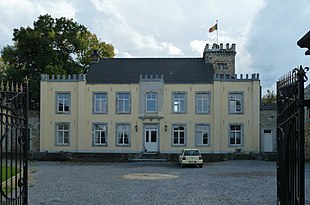
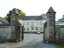
The Knoppenburg , more rarely Castle Knoppenburg called, is a former farm with neo-classical mansion on the western edge of about Raeren belonging hamlet Neudorf in German-speaking area of Belgium .
The property takes its name from two onion domes whose roofs are reminiscent of buds and which are called "Knop" in the Raeren dialect. The plant is since November 17, 1989 under monument protection .
history
The exact beginnings of the estate are not known. The property was probably separated from the larger Belven estate in the 16th century and initially belonged to Bertolf von Belven. At that time the estate was still called "Hof op der Heyde". In 1615, Simon Bertolf von Belven gave the property to Wilhelm Vischer (also written as Fischer) and his son Leonard. This extended the manor with the farm wings and round corner towers that are still preserved today. He also acquired the glories of Eupen and Stockem .
At the beginning of the 18th century, the Vischer family was financially ruined and forced to sell the Knoppenburg. It came to Lambert Xaver Lambertz , the artistic director of the Limburg province and later mayor of the imperial city of Aachen . He was one of the family's believers . After his death in 1717, the facility was initially shared by his children. The son Karl Johann Wilhelm Lambertz took over the property as sole owner and bequeathed it to Peter Joseph Ignatz de Lassaulx (also written de La Saulx), the son of a relative, in the second half of the 18th century. Lassaulx was president of the Malmedyer district court and later councilor at the Cologne Court of Appeal . His family built a new residential building in the 18th century and changed the facades and the towers of the farm wing.
On his death in 1831, Peter Joseph Ignatz de Lassaulx left the Knoppenburg to Josephine Katherine Theresia Henriette, his only daughter from his second marriage to Henriette Marguerite Thérèse dʼOutrelepont. She married Maximilian Hubert Joseph von Heinsberg in 1874. The couple was inherited by their daughter Maria Theresia Hubertine. She brought the property to this family through her marriage to Adolf Karl Franz Hubert von Blankart on October 23, 1875 and was finally inherited by her daughter Martha Maria. This sold the property on December 24, 1936 to Joseph Heinrich Wilhelm van Laar.
In the mid-1980s, the Raeren community thought of setting up a youth hostel in the complex . Up until then, only the landscape around the property and the two round towers were under monument protection. Because the subsidy for the construction work associated with the youth hostel would have been higher, the protection was extended to the entire complex. The purchase of the Knoppenburg by the municipality failed, however. In 1996 it was considered to loosen the protection again to make it easier for owners to repair the now run-down buildings, but this came to nothing. The high building requirements associated with the preservation of historical monuments were the reason why the renovation and restoration work that had begun after a change of ownership in 1998 was not completed, but instead the facility was for sale again from 2008. The new owners will continue the work from 2009.
description
The facility is a three-wing building complex at the end of an approximately 200 meter long chestnut avenue . At the beginning of this avenue is a farm belonging to the Knoppenburg. The three wings of the Knoppenburg form a U-shape that is open to the road to the northwest. The courtyard surrounded by them is closed off on this side by a wall made of sandstone and bricks . In the middle is the wrought-iron entrance gate between two polygonal turrets with slate-covered helmets . It dates from the 19th century.
The oldest building structure can be found in the two economic wings in the northeast and southwest. They essentially date from the 16th century and used to be used as stables, stores and as accommodation for servants . Your masonry is made of quarry stone . The south-west wing has a round-arched car entrance with monolithic bluestone pillars. The windows of the north-east wing, which has numerous S-shaped wall anchors , are arched and closed off by a central wedge . The hipped roof of the northwest wing is covered with tiles , while the roof of the southwest wing has a shingle roof. On the western end of the farm wing - and thus on the north and west corners of the property - there are two round towers made of blue rubble, some of which have been repaired with sand rubble. Their clapboard-covered onion hoods are crowned by weather vanes that show the coat of arms of the Lassaulx family. They say that the Lassaulx changed the towers in the 18th century.
The south-eastern side of the courtyard is occupied by a classicist mansion from the 18th century. Its two storeys are closed off by a clapboard, high pitched roof. The symmetrically designed plaster facade facing the courtyard is divided into seven axes by large windows with straight lintels . The masonry of the approximately 10 × 20 meter building consists partly of quarry stone and partly of bricks. The rear facade facing the park is a little more elaborate with its corner blocks . It shows five axes of arched windows with bluestone reveals , with those on the upper floor being lower than those on the first floor. The coat of arms of the Lassaulx family can be found above the entrance door in the central axis, identifying them as the owner. A five-storey square tower is in front of the southern short side of the house. With its crenellated wreath, it resembles the tower of Thor Castle in Astenet . Its flat roof serves as a viewing terrace.
To the east of the mansion is a landscaped park with old trees. Together with the ensemble of buildings , it covers an area of around 1.36 hectares . However, this only makes up a small part of the approximately 46 hectares of land belonging to the Knoppenburg. There are several natural ponds in it.
literature
- Administration of the German-speaking Community (Hrsg.): Raeren (= monument directory. Volume 8). Administration of the German-speaking Community, Eupen 1990, pp. 343–345.
- Guy Poswick: Les Délices du Limbourg. Self-published, Verviers 1951, pp. 373–378 ( digitized version ).
- Heribert Reiners , Heinrich Neu : The art monuments of Eupen-Malmedy. Reprint of the edition from 1935. Pädagogischer Verlag Schwann, Düsseldorf 1982, ISBN 3-590-32117-2 , pp. 172-173.
Web links
Footnotes
- ↑ Information about the Knoppenburg on the website of the municipality of Raeren , accessed on December 10, 2018.
- ↑ a b c d Heinz Gensterblum: The Knoppenburg will be saved from complete ruin. In: Grenz-Echo . Online edition from December 10, 2010.
- ↑ a b c Information about the Knoppenburg on the cultural heritage website of the German-speaking Community , accessed on December 10, 2018.
- ↑ a b Administration of the German-speaking Community (ed.): Raeren (= monuments directory. Volume 8). 1990, p. 343.
- ↑ Information according to the cultural heritage website of the German-speaking Community . In other publications the dates 1602 and 1612 can be found for the donation.
- ^ Christian Quix: Contributions to a historical-topographical description of the Eupen district, together with an appendix: The former Grafschaft Mesch. Mayer, Aachen 1837, p. 165 ( digitized version ).
- ^ Guy Poswick: Les Délices du Limbourg. 1951, p. 374.
- ↑ a b c d e Guy Poswick: Les Délices du Limbourg. 1951, p. 377.
- ↑ a b Knoppenburg Castle. Land as far as the eye can see ... and a tax gift from Thousand and One Nights. Sales brochure. 2008, p. 5.
- ^ Administration of the German-speaking Community (ed.): Raeren (= monuments directory. Volume 8). 1990, p. 345.
- ↑ a b c Knoppenburg Castle. Land as far as the eye can see ... and a tax gift from Thousand and One Nights. Sales brochure. 2008, p. 2.
- ^ Administration of the German-speaking Community (ed.): Raeren (= monuments directory. Volume 8). 1990, p. 344.
Coordinates: 50 ° 40 ′ 2.2 " N , 6 ° 5 ′ 58.1" E


