Koło (rural municipality)
| Gmina Koło | ||
|---|---|---|

|
|
|
| Basic data | ||
| State : | Poland | |
| Voivodeship : | Greater Poland | |
| Powiat : | Koło | |
| Geographic location : | 52 ° 12 ′ N , 18 ° 39 ′ E | |
| Residents : | see Gmina | |
| Postal code : | 62-600 | |
| Telephone code : | (+48) 63 | |
| License plate : | PKL | |
| Economy and Transport | ||
| Street : | Poznan - Warsaw | |
| Rail route : | Warsaw – Poznan | |
| Next international airport : | Łódź | |
| Gmina | ||
| Gminatype: | Rural community | |
| Gmina structure: | 26 villages | |
| 24 school offices | ||
| Surface: | 101.88 km² | |
| Residents: | 7742 (Jun. 30, 2019) |
|
| Population density : | 76 inhabitants / km² | |
| Community number ( GUS ): | 3009072 | |
| administration | ||
| Wójt : | Mariusz Rybczyński | |
| Address: | ul.Sienkiewicza 21/23 62-600 Koło |
|
The gmina wiejska Koło [ 'kɔwɔ ] is an independent rural municipality in Poland in the powiat Koło in the Greater Poland Voivodeship . Its seat is in the city of Koło (German: Kolo).
geography
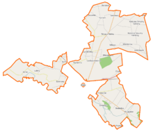
The rural community is divided into two areas. The smaller one is in the west of the city of Koło, the larger one in the north and east.
Both parts of the area are crossed by the Warta .
history
1975 to 1998 the rural community belonged to the Konin Voivodeship .
Community structure
The rural municipality of Koło, to which the city of Koło itself does not belong, has an area of 101.88 km², on which (as of June 30, 2019) 7742 people live.
It consists of 24 school offices and 26 localities:
| Surname | German name (1940-1945) |
Surname | German name (1940-1945) |
|---|---|---|---|
| Aleksandrówka | Alexanderhof | Lucjanowo | Kiefernried |
| Borki | Eckdorf | Mikołajówek | |
| Chojny | Pine trees | Ochle | Kieselstädt |
| Czołowo | Star Valley | Podlesie | Niederwalden |
| Czołowo-Kolonia | Powiercie | Arnsdorf | |
| Dąbrowa | Eichendorf | Powiercie Colonia | New Arnsdorf |
| Dzierawy | Pastures | Przybyłów |
1940–1943 Königsbach 1943–1945 Priebelbach |
| Kaczyniec | Blumenau | Ruchenna | Sun Valley |
| Kamień | Ostenfels | Skobielice | Annafeld |
| Kiełczew Górny | Oberhauern | Sokołowo | Falkendorf |
| Kiełczew Smużny Czwarty | Stellutyszki | ||
| Kiełczew Smużny Pierwszy | Tusks | Wandynów | Windau |
| Leśnica | Forest hill | Wrząca Wielka | Sudfeld |
| Lubiny | Love valley | Zawadka | Fight |
Other villages and hamlets are: Budy Przybyłowskie, Dorobna, Witowo, Wrząca Wielka-Kolonia.
Web links
Commons : Gmina Koło - collection of images, videos and audio files
Footnotes
- ↑ population. Size and Structure by Territorial Division. As of June 30, 2019. Główny Urząd Statystyczny (GUS) (PDF files; 0.99 MiB), accessed December 24, 2019 .

