
Kodaikanal
| Kodaikanal கொடைக்கானல் |
|||
|---|---|---|---|
|
|||
| State : |
|
||
| State : | Tamil Nadu | ||
| District : | Dindigul | ||
| Sub-district : | Kodaikanal | ||
| Location : | 10 ° 14 ′ N , 77 ° 29 ′ E | ||
| Height : | 2195 m | ||
| Residents : | 36,501 (2011) | ||
 |
|||

Kodaikanal ( Tamil : கொடைக்கானல் Koṭaikkāṉal [ ˈkoɖaiˌkːaːnəl ], Kodai for short ) is a city in the Indian state of Tamil Nadu . It is located in the Palani Mountains at around 2200 meters above sea level and has almost 37,000 inhabitants (2011 census). Besides Udagamandalam in the Nilgiri Mountains , Kodaikanal is the most famous hill station in Tamil Nadu and a popular holiday destination, especially during the summer months because of its cool mountain climate.
geography
Kodaikanal is located in western Tamil Nadu in the Palani Mountains , an extension of the Western Ghats . The city is located on a plateau at around 2200 meters above sea level, surrounded by the wooded mountain landscape of the Palani Mountains. The center of the place is an artificial lake, the Kodaikanal Lake .
Kodaikanal belongs to the district of Dindigul and is the capital of the taluk (sub-district) Kodaikanal. The district capital Dindigul is located around 100 kilometers east in the lowlands. The nearest major city is Madurai 120 kilometers southeast. Chennai , the state capital, is 520 kilometers from Kodaikanal.
climate
Because of its altitude, Kodaikanal has a mountainous climate with moderate temperatures. At the same time, the seasonal temperature fluctuations are small due to the location in the tropics. The average maximum temperature is 19.8 ° C in summer and 17.3 ° C in winter, the average minimum temperature is 11.3 ° C in summer and 8.3 ° C in winter. The annual precipitation averages 770 millimeters.
| Kodaikanal | ||||||||||||||||||||||||||||||||||||||||||||||||
|---|---|---|---|---|---|---|---|---|---|---|---|---|---|---|---|---|---|---|---|---|---|---|---|---|---|---|---|---|---|---|---|---|---|---|---|---|---|---|---|---|---|---|---|---|---|---|---|---|
| Climate diagram | ||||||||||||||||||||||||||||||||||||||||||||||||
| ||||||||||||||||||||||||||||||||||||||||||||||||
|
Average monthly temperatures and rainfall for Kodaikanal
Source: WMO ; wetterkontor.de
|
|||||||||||||||||||||||||||||||||||||||||||||||||||||||||||||||||||||||||||||||||||||||||||||||||||||||||||||||||||||||||||||||||||||||||||||||||||||||||||||||||||||
history

The Nilgiri Mountains were originally settled by the Adivasi tribe of the Paliyan and later arable farmers who immigrated from the lowlands. During the British colonial era , British colonial officials and western missionaries discovered the climatically favorable Palani Mountains as a place of retreat where they could escape the heat of the lowlands. The first Westerner to visit Kodaikanal was British Lieutenant BS Ward in 1821 . In 1845, American missionaries founded the Kodaikanal settlement as a mission station. In the following years, more Westerners settled in Kodaikanal, so that the place had 1,912 permanent residents in 1901. There were also numerous summer guests who only spent the hot season in Kodaikanal. 1899 Kodaikanal became the township ( municipality applicable). The Kodai Road train station at the foot of the Palani Mountains was set up as early as 1875 to facilitate access to Kodaikanal. The ascent to Kodaikanal still had to be done on foot or with the help of porters. It was not until 1914 that Kodaikanal was connected to the road network with the construction of Kodai Ghat Road .
After Indian independence in 1947, most of the British left India. Instead, Kodaikanal has become a popular vacation destination for Indian domestic tourists. With the continued growth of the Indian middle class, Kodaikanal is becoming increasingly popular.
Attractions


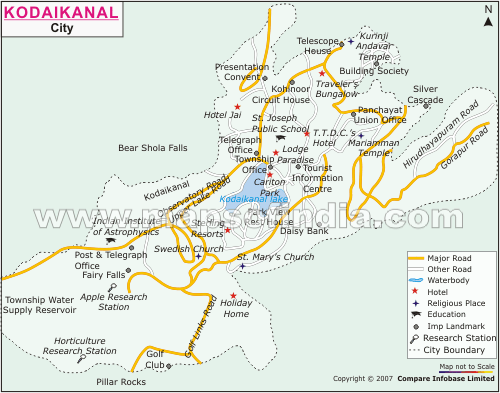
The star-shaped Kodaikanal Lake in the center of the city was artificially created in 1863. It is 24 hectares and is bordered by a five-kilometer-long riverside path. Many tourists use it for boat trips or walks. On the east bank of the lake is the Bryant's Park Botanical Garden .
The greatest attraction of Kodaikanal is likely to be the surrounding mountain landscape. The one kilometer long Coaker's Walk leads along the steep slope on the south side of Kodaikanal . When the weather is clear, there are spectacular views far into the plain from here. Other popular viewpoints in and around Kodaikanal include Green Valley View three miles from the lake, Silent Valley View, and Dolphin's Nose Rock eight kilometers away. Seven kilometers from the lake are the Pillar Rocks , a spectacular rock formation made up of three 122 meter high rocks. Waterfalls in the area around Kodaikanal are the 55 meter high Silver Cascade and Bear Shola Falls .
At the highest point of Kodaikanal at 2,343 meters above sea level is the Kodaikanal observatory , a solar physics observatory of the Indian Institute of Astrophysics founded in 1899 . The telescope with an opening width of 20 cm is still occasionally used to observe comets and occultations . At other times it is open to visitors.
As a relic of the colonial era, Kodaikanal has numerous church buildings. The most famous church in Kodaikanal is La Salette Church , which is dedicated to Our Lady of La Salette . The most important Hindu temple in Kodaikanal is the Kurinji Andavar Temple . He is dedicated to the god Murugan in his capacity as lord of the mountain region ( kurinji ).
population
49 percent of the residents of Kodaikanal are Hindus , 39 percent are Christians and 12 percent are Muslims . As in all of Tamil Nadu, the main language is Tamil, which is spoken by 99 percent of the population as their mother tongue.
economy
The main industry of Kodaikanal is tourism. The Kodaikanal, dubbed the “ Princess of the Hill Stations ”, is Tamil Nadu's most important hill station , along with Udagamandalam (Ooty) in the Nilgiri Mountains , and one of the most popular travel destinations in the state. In 2011, Kodaikanal was visited by 7.9 million tourists. As in all of Tamil Nadu, the trend in visitor numbers is increasing rapidly. Kodaikanal is mainly visited by local tourists and is especially popular with wedding couples. The peak season is the hot season between April and June when many inland tourists escape the heat in the plains for the cooler mountainous areas.
Between 1984 and 2001 a factory of the Hindustan-Unilever group in Kodaikanal manufactured thermometers . The improper disposal of waste from the factory has resulted in severe environmental damage from mercury emissions .
Transport and infrastructure

Kodaikanal can only be reached by road. The 57 kilometer long Kodaikanal Ghat Road (State Highway 156) begins west of Batlagundu at the foot of the Palani Mountains and leads from the south to Kodaikanal, the Palani Ghat Road connects Kodaikanal with Palani , located on the northern edge of the mountains . The connecting road from Kodaikanal to the west over the main ridge of the Western Ghats to Munnar in the neighboring state of Kerala , which the British laid out in 1942 as an evacuation route for fear of a Japanese invasion of India, was closed in 1990.
Kodai Road Station is a two-hour bus ride away on the plane on the Chennai to Madurai Railway. The nearest airport is Madurai Airport (135 kilometers).
Due to the difficult-to-reach location of Kodaikanal, food and other goods imported from the rest of India are more expensive than elsewhere. The post route is lengthened by the remote location. The city's infrastructure is well developed; there are retail stores, restaurants, hotels, banks and two hospitals. Kodaikanal has a larger number of educational institutions, including the renowned Kodaikanal International School , which opened as a Christian school formerly called Highclerc School on July 1, 1901 for the education of the children of American missionaries.
literature
- Kodaikanal . With watercolors by FA Baker. Diocesan Press, Madras. (No information on author and year. Date of publication between 1920 and 1940.)
- Charlotte Chandler Wyckoff: Kodaikanal: 1845-1945. London Mission Press, Nagercoil, Travancore, India. 1945.
- Nora Mitchell: The Indian Hill Station Kodaikanal . Series: Research paper, University of Chicago, Department of Geography , 141. University of Chicago, Chicago Ill., 1972.
- Volker Winkler: Kodaikanal. Land of the Clouds . Illustrated book. Hillsboro Press, Franklin (Tennessee) 1999.
Web links
Individual evidence
- ^ Census of India 2011.
- ^ Website of the Kodaikanal Municipality: About City. ( Memento of the original from September 29, 2011 in the Internet Archive ) Info: The archive link was inserted automatically and has not yet been checked. Please check the original and archive link according to the instructions and then remove this notice.
- ^ Imperial Gazetteer of India, London 1908, Vol. 15, p. 338.
- ^ Census of India 2011: C-1 Population By Religious Community. Tamil Nadu.
- ↑ Census of India 2001: C-16 City: Population by Mother Tongue (Tamil Nadu), accessed under Tabulations Plan of Census Year - 2001 .
- ^ The Hindu, March 1, 2012: "State attracted over 14 crore tourists during 2011".
- ↑ Sarah Hiddleston: Poisoned ground, ( Memento of the original from November 21, 2010 in the Internet Archive ) Info: The archive link was inserted automatically and has not yet been checked. Please check the original and archive link according to the instructions and then remove this notice. Frontline 27 (19), September 2010.