Kossa
|
Kossa
community Laußig
Coordinates: 51 ° 37 ′ 0 ″ N , 12 ° 41 ′ 0 ″ E
|
|
|---|---|
| Height : | 125 m |
| Area : | 58 ha |
| Incorporation : | July 1, 2007 |
| Postal code : | 04849 |
| Area code : | 034243 |
Kossa is a district of the municipality Laussig in the district of North Saxony , Free State of Saxony . Until 2007, Kossa was the capital of the municipality of the same name, to which the districts of Kossa, Authausen , Durchwehna , Görschlitz and Pressel belonged.
Geography and traffic
Kossa is about 10 km northeast of Bad Düben and 20 km north of Eilenburg . The B 183 leads through the village. In the north, the Kossa district borders the state of Saxony-Anhalt . The landscape is characterized by the large, hilly forest and heathland areas of the Dübener Heide .
history
As can be seen from the names, the places are mostly of Slavic origin. The district of Kossa was first mentioned in 1464 as "Kassaw" and in 1492 as Koße . The place name comes from the Slavic and means something like "scythe". Like most of the region, the place suffered badly from the aftermath of the Thirty Years War and the plague. In 1639 there were only nine people living in Kossa.
Kossa, located between the Electoral Saxon offices of Düben and Torgau , belonged as an exclave to the Electoral Saxon or Royal Saxon Office of Eilenburg until 1815 . The decisions of the Congress of Vienna the place to Prussia came only in 1816 the district Bitterfeld in the administrative district of Merseburg of the Province of Saxony assigned to which he belonged until 1,952th During the territorial reform in the GDR in 1952, Kossa came to the Eilenburg district , which was added to the Delitzsch district in 1994 .
The municipality of Kossa was enlarged on January 1, 1974 to include the former municipality of Durchwehna.
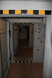
In 1979 the NVA bunker between Kossa and Söllichau was completed.
On July 1, 1996, the Authausen community joined Kossa. From January 1, 1999, the name of the municipality of Kossa stood for all five associated localities of Authausen, Durchwehna, Görschlitz, Kossa and Pressel. On July 1, 2007, Kossa merged with the neighboring municipality of Laußig to form the new municipality of Lau needed , after they had previously formed the administrative association Laussig .
Memorials
- Memorial stone in the cemetery Kossa and at the exit Durchwehna for 58 killed KZ inmates of a death march from one of the outer stock of the Buchenwald
Attractions

- Military Museum Kossa
- Düben Heath Nature Park
- Post windmills "Fiehn" and "Ludwig" near Authausen
- Newly built old Germanic house near Authausen
- Presseler manor house
- "Hexenstein" near Görschlitz
- Moor landscape near Pressel
Personalities
- Hans-Jochen Tschiche (1929–2015), clergyman, civil rights activist in the GDR and politician
Individual evidence
- ^ Karlheinz Blaschke , Uwe Ulrich Jäschke : Kursächsischer Ämteratlas. Leipzig 2009, ISBN 978-3-937386-14-0 ; P. 56 f.
- ^ The district of Bitterfeld in the municipality register 1900
- ↑ Municipalities 1994 and their changes since January 1, 1948 in the new federal states , Metzler-Poeschel publishing house, Stuttgart, 1995, ISBN 3-8246-0321-7 , publisher: Federal Statistical Office
- ^ StBA: Changes in the municipalities in Germany, see 1996
- ↑ StBA: Changes in the municipalities in Germany, see 1999
literature
- Kossa . In: August Schumann : Complete State, Post and Newspaper Lexicon of Saxony. 5th volume. Schumann, Zwickau 1818, p. 90 f.
Web links
- Kossa in the Digital Historical Directory of Saxony


