
At the Krögel
| At the Krögel | |
|---|---|
|
|
|
 |
|
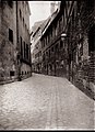
| View of the private street from Neue Jüdenstrasse, 2011 | |
| Basic data | |
| place | Berlin |
| District | center |
| Created | in the 16th century (road) |
| Newly designed | 2000 |
| Hist. Names |
Cruvel, Krögel, The Krögel Krögel Gasse, Am Krögel |
| Connecting roads |
New Jüdenstrasse |
| Buildings | Administration building of Berliner Wasserbetriebe , director's house |
| use | |
| User groups | Delivery traffic , company employees |
| Technical specifications | |
| Street length | 150 meters |
Am Krögel is a 150-meter-long private road that was laid out in 2000 on the grounds of the Berliner Wasserbetriebe in the Berlin district of Mitte of the district of the same name in the medieval city center . The name refers to the medieval, 120-meter-long street Am Krögel , which existed until 1937.
Location and course
The redesigned street Am Krögel begins on Stralauer Straße running south and bends to the east until it joins Neue Jüdenstraße. The street has reciprocal house numbering , but this only extends to house number 3.
The original street Am Krögel began about 50 meters further west at Molkenmarkt and led south to the bank of the Spree .
Naming
Linguistically, the word Krögel comes from the Low German 'krouwel', which was mostly used for watercourses and means something like curved . This is the name of a connection from the Spree to the Molkenmarkt, in the course of which the alley Am Krögel was created after filling up. The road on Krögel was only in the early 19th century Krögel called before it was called Krögelgasse . The road and the adjacent buildings on Am Krögel 1 to the east were generally referred to as Der Krögel .
history
Middle Ages to the 19th century
The watercourse served as a landing stage for barges . The Berliners also used Krewel or Krögel to refer to the Handelshof built on the banks of the city of Berlin. Over the centuries, the bay was gradually filled in and built over with residential buildings and warehouses, leaving only a narrow alley towards the Spree, from where the Berliners got their water. At the beginning of the 20th century, the street Am Krögel had a single building in which many craftsman families lived.
The medieval development has been documented many times by photographers such as Heinrich Zille , Waldemar Titzenthaler and Friedrich Albert Schwartz .
Since the 20th century
In 1935 the Krögel fell completely victim to the rebuilding of the Reichsmünze . The Krögel, with its old, narrow and unsanitary buildings, was until then generally regarded as a symbol of the often inhumane housing conditions in Berlin.
In the workshop of the master carpenter Franz Wolff, there was a small Krögel museum with old pictures and furniture and other household items until his death in 1920 . Kurt Pomplun says that there was a sundial in the Krögel with the signature "Mors certa, hora incerta" ("Death is certain, the hour is uncertain"), which the Berlin vernacular would have translated as "This clock is sure to be wrong" (Compare also kitchen Latin ).
When the head office of Berliner Wasserbetriebe was set up, the historical name was transferred to the access road on the premises. Since August 25, 2000 there is again a street Am Krögel , albeit in a different location.
At the Krögel

Am Krögel, view to the rear of the Schwerin Palace

Big Krögelhof

View over the Spree to the street Am Krögel
.jpg)
_(Zeno_Fotografie).jpg)
.jpg)

See also
literature
- Susanne Gänshirt-Heinemann: The Krögel: An alley in old Berlin . Haude and Spener, Berlin 2000, ISBN 3-7759-0464-6 .
Web links
-
Am Krögel (since 2000). In: Street name lexicon of the Luisenstädtischer Bildungsverein (near Kaupert )
- At the Krögel (historical) . In: Luise.
Individual evidence
- ↑ The Krögel . In: Karl Neander von Petersheiden: Illustrative tables , 1799, p. 88 (located between Molkenmarkt, Stralauer Straße and Spree).
- ↑ a b Am Krögel . In: Address book for Berlin and its suburbs , 1901, part 3, p. 339 (explanation of names).
- ↑ Susanne Gänshirt Heinemann: Der Krögel , Berlin 2003 ( ISBN 3-8305-0182-X )
- ↑ The Krögel . In: The Stralauer Fischzug . Legends, stories and customs from old Berlin . New Life, Berlin 1987, ISBN 3-355-00326-3 , p. 121 .
- ↑ The end of the Krögel Museum . In: Vossische Zeitung , No. 283 (Sunday edition) of June 6, 1920, first supplement
Coordinates: 52 ° 30 ′ 56.6 " N , 13 ° 24 ′ 34.5" E