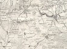
Krępsko (Szydłowo)
Krępsko ( German Kramske ) is a village in the rural community Szydłowo ( Groß Wittenberg ) in the powiat Pilski (district Schneidemühl ) of the Polish Voivodeship of Greater Poland .
Geographical location
Krępsko (Kramske) is located in Western Pomerania on the Gwda (Küddow) , about twenty kilometers east of the town of Wałcz (Deutsch Krone) , thirteen kilometers north of the town of Piła (Schneidemühl) and fifteen kilometers southwest of the town of Krajenka (Krojanke) .
history
In 1600 Peter Potulicki, Starost of Usch , issued Dionys Clawitter a privilege over this village. In 1617 the village was called Krampzig , in 1641 Krępa .
In the 1930s, the district of Kramske covered an area of 29.7 km², and there were 62 inhabited houses within the municipal boundaries.
Until 1945 Kramske belonged to the district German crown in marienwerder the Prussian province of West Prussia . Between 1919 and 1939 it was in the province of Posen-West Prussia incorporated and came in 1939 to the administrative district of Posen-West Prussia of Pomerania .
Towards the end of the Second World War , the Red Army occupied the region in the spring of 1945 . Shortly thereafter, Kremske was placed under Polish administration. As far as the people had not fled, they were in the period that followed sold . Kramske was renamed Krępsko .
Population numbers
- 1864: 465, including 420 Evangelicals and 45 Catholics
- 1925: 454, including 391 Evangelicals and 63 Catholics, no Jews
- 1933: 433
- 1939: 448
literature
- Friedrich Wilhelm Ferdinand Schmitt : History of the Deutsch-Croner circle . Thorn 1867 ( e-copy ).
- Franz Schultz : History of the Deutsch-Krone district. German Crown 1902
- Friedwald Moeller: Old Prussian Evangelical Pastors' Book from the Reformation to the Expulsion in 1945. Volume 1, Hamburg 1968
- Karl Ruprecht: Heimatstadt - Heimatkreis Deutsch Krone. Bad Essen 1981
Web links
- Gunthard Stübs and Pommersche Forschungsgemeinschaft: The municipality of Kramske in the former Deutsch Krone district in Pomerania (2011).
- Picture of the Catholic chapel in Kramske (Krępsko), Deutsch Krone district, West Prussia (William Remus, 2007) (English)
Footnotes
- ^ Friedrich Wilhelm Ferdinand Schmitt : History of the Deutsch-Croner circle . Thorn 1867, p. 227 .
- ↑ a b http://gemeinde.kramske.kreis-deutsch-krone.de/
- ^ E. Jacobson: Topographical-statistical manual for the administrative district Marienwerder . Danzig 1868, p. 60, no.132.
- ^ A b Michael Rademacher: German administrative history from the unification of the empire in 1871 to the reunification in 1990. deutschkrone.html # ew39dtkrdkrmske. (Online material for the dissertation, Osnabrück 2006).
Coordinates: 53 ° 16 ' N , 16 ° 47' E


