
Kranzhorn
| Kranzhorn | ||
|---|---|---|
 Kranzhorn of Oberaudorf seen from |
||
| height |
1366 m above sea level NHN 1368 m above sea level A. |
|
| location | Bavaria , Germany and Tyrol , Austria | |
| Mountains | Chiemgau Alps | |
| Dominance | 2.5 km → Kitzstein | |
| Notch height | 387 m ↓ Kitzbichler Alm | |
| Coordinates | 47 ° 42 '2 " N , 12 ° 11' 1" E | |
|
||
| rock | Main dolomite | |
| Age of the rock | Upper Carnium - Norium | |

The Kranzhorn is 1368 m above sea level. A. high mountain on the western edge of the Chiemgau Alps . The German-Austrian border between Bavaria and Tyrol runs over its summit .
The Kranzhorn and the opposite Wildbarren formed during the Würm the Alpentor of the Inn Valley glacier .
On the German side, the mountain belongs to the municipality of Nussdorf am Inn in the Rosenheim district , and on the Austrian side to the municipality of Erl in the Kufstein district . The summit of the mountain bears two summit crosses and can be seen from far from the Inn valley . From the summit you have a good view of the Wendelstein in the west and the Wilder Kaiser in the south. Along with the Hochries and the Heuberg , the Kranzhorn is one of the most popular destinations for hikers in the Chiemgau Alps.
gallery

Seen from the northwest

The two summit crosses

The Bavarian summit cross
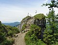
The Kranzhorn summit consists of a ledge

On the Kranzhorn summit

View from the summit of the Kranzhorn over the Inn valley to the north

View from the summit of the Kranzhorn over the Inn valley to the south


_Bayr._Gipfelkreuz.jpg)


Web links
Individual evidence
- ↑ Geological map of Bavaria with explanations (1: 500,000). Bavarian Geological State Office, 1998.