
Krasznokvajda
| Krasznokvajda | |||||
|
|||||
| Basic data | |||||
|---|---|---|---|---|---|
| State : | Hungary | ||||
| Region : | Northern Hungary | ||||
| County : | Borsod-Abaúj-Zemplén | ||||
| Small area until December 31, 2012 : | Encs | ||||
| District since 1.1.2013 : | Encs | ||||
| Coordinates : | 48 ° 28 ' N , 20 ° 58' E | ||||
| Height : | 203 m | ||||
| Area : | 11.44 km² | ||||
| Residents : | 441 (Jan. 1, 2011) | ||||
| Population density : | 39 inhabitants per km² | ||||
| Telephone code : | (+36) 47 | ||||
| Postal code : | 3821 | ||||
| KSH kódja: | 19576 | ||||
| Structure and administration (as of 2020) | |||||
| Community type : | local community | ||||
| Mayor : | Béla Tóbis (independent) | ||||
| Postal address : | Scholtz Albin tér 3 3821 Krasznokvajda |
||||
| Website : | |||||
| (Source: A Magyar Köztársaság helységnévkönyve 2011. január 1st at Központi statisztikai hivatal ) | |||||


Krasznokvajda is a Hungarian community in the county Encs in Borsod-Abaúj-Zemplén .
Geographical location
Krasznokvajda is located in northern Hungary , 60 kilometers north of Miskolc . Neighboring communities are Büttös two kilometers east, Szászfa two kilometers west and Perecse four kilometers north. The nearest town is Encs located 25 kilometers southeast of Krasznokvajda.
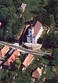
photos

Szentimrey Castle
Szűz Mária Neve Roman Catholic Church


Attractions
- Greek Catholic Chapel Keresztelő Szent János születése
- Reformed Church
- Szűz Mária Neve Roman Catholic Church , built in 1759, Baroque style
- Szentimrey Castle ( Szentimrey-kastély )
traffic
Road No. 2613 leads through Krasznokvajda. The nearest train station is in Encs.