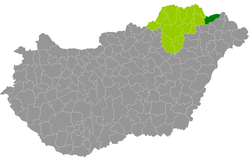
Cigánd district
| circle Cigándi járás
Cigánd |
|
|---|---|
 Location of the district in Hungary |
|
| Basic data | |
| Country | Hungary |
| County | Borsod-Abaúj-Zemplén |
| Seat | Cigand |
| surface | 390 km² |
| Residents | 15,956 (January 1, 2016) |
| density | 41 inhabitants per km² |
The district of Cigánd (Hungarian Cigándi járás ) is the easternmost district in the northern Hungarian county of Borsod-Abaúj-Zemplén . It borders in the north with 9 of its 15 municipalities on Slovakia and in the south on the Szabolcs-Szatmár-Bereg county . The district was created in early 2013 as the successor to the small area Bodrogköz (Hungarian Bodrogközi kistérség ). 2 of the 17 municipalities in the small area moved to the Sátoraljaújhely district . The district has a lower population density than the entire county. District seat is the only city, Cigánd .
Community overview
| local community | status | Origin small area |
population | surface | Population density (inh / km²) |
||
|---|---|---|---|---|---|---|---|
| October 01, 2011 | 01/01/2013 | 01/01/2016 | |||||
| Bodroghalom | local community | Bodrogköz | 1,381 | 1,384 | 1,354 | 26.86 | 50.4 |
| Cigand | city | Bodrogköz | 2,963 | 3,037 | 3,058 | 56.76 | 53.9 |
| Dámóc * | local community | Bodrogköz | 362 | 364 | 358 | 15.99 | 22.4 |
| Karcsa * | local community | Bodrogköz | 1,824 | 1,859 | 1,813 | 43.69 | 41.5 |
| Diamonds * | local community | Bodrogköz | 494 | 487 | 482 | 15.32 | 31.5 |
| Kisrozvágy * | local community | Bodrogköz | 158 | 175 | 158 | 8.34 | 18.9 |
| Lácacséke * | local community | Bodrogköz | 329 | 334 | 293 | 16.25 | 18.0 |
| Nagyrozvágy * | local community | Bodrogköz | 637 | 641 | 625 | 26.81 | 23.3 |
| Pácin * | local community | Bodrogköz | 1,448 | 1,428 | 1,371 | 33.93 | 40.4 |
| Révleányvár | local community | Bodrogköz | 438 | 445 | 450 | 16.50 | 27.3 |
| Ricse | Large community | Bodrogköz | 1,730 | 1,795 | 1,773 | 24.75 | 71.6 |
| Semjén * | local community | Bodrogköz | 451 | 455 | 499 | 7.84 | 63.6 |
| Tiszacsermely | local community | Bodrogköz | 574 | 577 | 545 | 20.28 | 26.9 |
| Tiszakarád | local community | Bodrogköz | 2,464 | 2,498 | 2.411 | 47.56 | 50.7 |
| Zemplénagárd * | local community | Bodrogköz | 789 | 815 | 766 | 29.09 | 26.3 |
| Cigánd district | 16,042 | 16,294 | 15,956 | 389.97 | 40.9 | ||
* Border municipality to Slovakia
swell
PDF and XLS files: 2011 Census ( Census )
2013 :; 2016:
Individual evidence
- ↑ KSH: 2011. Évi Népszámlálás. In: 3. Területi adatok. KSH, accessed on December 24, 2016 (Hungarian, also via: http://www.terezvaros.hu/testuleti/nepsz2011-3/pdf/nepsz2011_03_05.pdf ).
- ↑ KSH: Regional data - Borsod-Abaúj-Zemplén county. KSH, accessed on December 24, 2016 (English, 4th Data on Localities).
- ↑ KSH: Gazetteer of Hungary, 1st January, 2013. KSH, accessed March 8, 2017 (Hungarian / English).
- ↑ KSH: Gazetteer of Hungary, 1st January, 2016. KSH, accessed March 8, 2017 (Hungarian / English).