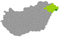
Csenger district
| circle Csengeri járás
Csenger |
|
|---|---|
 Location of the district in Hungary |
|
| Basic data | |
| Country | Hungary |
| County | Szabolcs-Szatmár-Bereg |
| Seat | Csenger |
| surface | 246.5 km² |
| Residents | 13,957 (January 1, 2016) |
| density | 57 inhabitants per km² |
The district of Csenger (Hungarian Csengeri járás ) is a district in the east of the northeast Hungarian county of Szabolcs-Szatmár-Bereg . It borders Fehérgyarmat County to the north and Mátészalka County to the west . In the east and south, 6 border municipalities form the state border with Romania .
history
During the Hungarian administrative reform in early 2013, the district emerged unchanged with all 11 municipalities from its predecessor, the small area of the same name (Hungarian Csengeri kistérség ).
Community overview
The district of Csenger has an average community size of 1,269 inhabitants on an area of 22.41 square kilometers. The population density of the poorest district is the lowest in the county. The administrative center is located in the only town, Csenger , in the southeast of the district.
| local community | status | Origin small area |
population | Area (km²) | Population density (inh / km²) |
||
|---|---|---|---|---|---|---|---|
| October 01, 2011 | 01/01/2013 | 01/01/2016 | |||||
| Csenger * | city | Csenger | 4,853 | 4,924 | 4,820 | 36.16 | 133.3 |
| Csengersima * | local community | Csenger | 703 | 779 | 778 | 23.80 | 32.7 |
| Csengerújfalu * | local community | Csenger | 785 | 819 | 955 | 25.61 | 37.3 |
| Komlódtótfalu * | local community | Csenger | 105 | 122 | 112 | 6.97 | 16.1 |
| Pátyod | local community | Csenger | 608 | 675 | 651 | 9.10 | 71.5 |
| Porcsalma | Large community | Csenger | 2,672 | 2,682 | 2,795 | 31.10 | 89.9 |
| Szamosangyalos | local community | Csenger | 488 | 477 | 540 | 8.04 | 67.2 |
| Szamosbecs | local community | Csenger | 360 | 374 | 371 | 6.71 | 55.3 |
| Szamostatárfalva | local community | Csenger | 302 | 308 | 322 | 4.50 | 71.6 |
| Tyukod * | Large community | Csenger | 2.003 | 2,041 | 1,985 | 62.18 | 31.9 |
| Ura * | local community | Csenger | 606 | 638 | 628 | 32.34 | 19.4 |
| Csenger district | 13,485 | 13,839 | 13,957 | 246.51 | 56.6 | ||
* Border municipality to Romania
swell
PDF and XLS files: 2011
Census :
2013:; 2016:
Individual evidence
- ↑ KSH: 2011. Évi Népszámlálás. In: 3. Területi adatok. KSH, accessed on December 26, 2016 (Hungarian, also via: http://www.terezvaros.hu/testuleti/nepsz2011-3/pdf/nepsz2011_03_15.pdf ).
- ↑ KSH: Regional data - Szabolcs-Szatmár-Bereg county. KSH, accessed on December 27, 2016 (English, 4th Data on Localities).
- ↑ KSH: Gazetteer of Hungary, 1st January, 2013. KSH, accessed April 2, 2017 (Hungarian / English).
- ↑ KSH: Gazetteer of Hungary, 1st January, 2016. KSH, accessed April 2, 2017 (Hungarian / English).