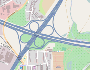
Braunschweig-Nord motorway junction
| Braunschweig-Nord motorway junction | |
|---|---|
|
|
|
| map | |
| location | |
| Country: | Germany |
| State : | Lower Saxony |
| Coordinates: | 52 ° 18 '52 " N , 10 ° 31' 2" E |
| Basic data | |
| Design type: | Shamrock |
| Bridges: | 1 (motorway) / 3 (other) |
| Construction year: | 1987 |
The Braunschweig-Nord motorway junction is a motorway junction in the north of the independent city of Braunschweig in Lower Saxony . This is where the federal motorway 2 ( E 30 ) in the direction of Hanover / Berlin and the federal motorway 391 (Braunschweiger Westtangente) cross.
Position and design
The motorway junction is located in the city of Braunschweig. Some of the housing estates are directly adjacent to the streets of the cross. The surrounding districts of Braunschweig are Wenden , Bienrode , Kralenriede and Veltenhof . The motorways bridge Schunter in the east and Gifhorner Strasse in the south. West of the cross, this street is again led over the A 2.
The structure was erected in the course of the construction of the A 2 in 1987. It is implemented as a clover leaf , with the north-western and south-eastern direct ramp adapting their route to the small space. They are also equipped with noise protection walls .
Traffic volume
| From | To | Average daily traffic volume |
Share of heavy goods traffic |
||||
|---|---|---|---|---|---|---|---|
| 2005 | 2010 | 2015 | 2005 | 2010 | 2015 | ||
| AS Braunschweig-Hafen (A 2) | AK Braunschweig-Nord | 77,800 | 82,500 | 87,900 | 21.6% | 22.3% | 21.7% |
| AK Braunschweig-Nord | AS Braunschweig Airport (A 2) | 93,800 | 81,700 | 81,800 | 20.7% | 22.3% | 22.0% |
| AS Braunschweig-Wenden (A 391) | AK Braunschweig-Nord | 27,300 | 26,900 | 16,900 | 9.9% | 7.0% | 5.5% |
| AK Braunschweig-Nord | AS Braunschweig-Hansestrasse (A 391) | 78,200 | 56,200 | 33,300 | 9.2% | 7.0% | 9.8% |
Web links
- Braunschweig-Nord motorway junction - motorway junctions and motorway triangles in Germany
Individual evidence
- ↑ Manual road traffic census 2005. (PDF) Results on federal motorways. BASt Statistics, 2005, accessed on June 27, 2020 .
- ↑ Manual road traffic census 2010. (PDF) Results on federal motorways. BASt Statistics, 2010, accessed on June 27, 2020 .
- ↑ Manual road traffic census 2015. (PDF) Results on federal motorways. BASt Statistics, 2015, accessed on August 26, 2017 .
