Bad Oeynhausen motorway junction
| Bad Oeynhausen motorway junction | |
|---|---|
|
|
|
| map | |
| location | |
| Country: | Germany |
| State : | North Rhine-Westphalia |
| Coordinates: | 52 ° 12 '19 " N , 8 ° 50' 27" E |
| Height: | 57 m above sea level NN |
| Basic data | |
| Design type: | Adapted shamrock |
| Bridges: | 2 (motorway) / 7 (other) |
| Construction year: | 1979 |
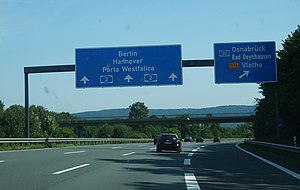
| Sign bridge on the A 2 in the direction of Hanover. | |
The Bad Oeynhausen motorway junction (abbreviation: AK Bad Oeynhausen ; short form: Bad Oeynhausen junction ) is a motorway junction in East Westphalia . It connects the federal highway 2 ( Oberhausen - Hanover - Berlin ) with the federal highway 30 ( Amsterdam - Bad Oeynhausen ), which becomes the federal highway 514 .
geography
The cross is in the urban area of Bad Oeynhausen in the Minden-Lübbecke district . The closest district is Rehme , with the districts Hüffe, Babbenhausen and Oberbecksen, all of which belong to Bad Oeynhausen. The surrounding towns and communities are Porta Westfalica and Vlotho . It is located about 55 km east of Osnabrück , about 65 km west of Hanover and about 30 km northeast of Bielefeld .
The nature parks TERRA.vita and Weserbergland Schaumburg-Hameln are nearby .
It is located not far from the Weser , in the area between the foothills of the Wiehengebirge and Weserbergland .
The Bad Oeynhausen motorway junction has junction number 32 on the A 2 and number 35 on the A 30.
history
The cross was completed in 1979 and replaced the old junction Bad Oeynhausen on Vlothoer Straße, which was further east. The A 30 turns south of the junction in the direction of Vlotho into the federal highway 514, which was expanded as a bypass around the city of Vlotho in the 1980s.
Design and state of development
The A 2 has been expanded to three lanes both in the direction of Dortmund and in the direction of Hanover. The A 30 has been expanded to two lanes, the B 514 remains two lanes for about 1 km after leaving the intersection area before it becomes two lanes again. The indirect connecting ramps are single-lane, the direct ramps, with the exception of the one in the northeast quadrant (single-lane), are two-lane.
The cross was laid out as an adapted clover leaf, whereby the two directional lanes of the A 2 are about 100 meters apart and the A 30 crosses on separate bridges. On the lower terrace within the cross there are some buildings, including that of a freight forwarder, as well as an off-road park.
Traffic volume
The cross is used by around 100,000 vehicles every day.
| From | To | Average daily traffic volume |
Share of heavy goods traffic |
||||
|---|---|---|---|---|---|---|---|
| 2005 | 2010 | 2015 | 2005 | 2010 | 2015 | ||
| AS Exter (A 2) | AK Bad Oeynhausen | 64,400 | 62,700 | 69,400 | 20.4% | 19.7% | 19.8% |
| AK Bad Oeynhausen | AS Porta Westfalica (A 2) | 84,200 | 87,400 | 94,600 | 22.2% | 22.3% | 21.7% |
| AS Rehme (A 30) | AK Bad Oeynhausen | 34,000 | 30,200 | 28,700 | 21.3% | 21.8% | 21.0% |
| AK Bad Oeynhausen | End of motorway (B 514) | 4,800 | 6,900 | 8,000 | 7.4% | 5.5% | 7.0% |
Movies
- Autobahn (film) , documentary about the traffic situation in Bad Oeynhausen and the construction of the northern bypass, 2019, 85 min., Script and direction: Daniel Abma , premiere: DOK Leipzig 2019, www.autobahn-film.de
Individual evidence
- ↑ Manual road traffic census 2005. (PDF) Results on federal motorways. BASt Statistics, 2005, accessed on June 24, 2020 .
- ↑ Manual road traffic census 2010. (PDF) Results on federal motorways. BASt Statistics, 2010, accessed on June 24, 2020 .
- ↑ Manual road traffic census 2015. (PDF) Results on federal motorways. BASt Statistics, 2015, accessed on August 26, 2017 .
- ↑ Manual road traffic census 2010. (PDF) Results on federal highways. BASt Statistics, 2010, accessed on June 24, 2020 .
- ↑ Manual road traffic census 2015. (PDF) Results on federal highways. BASt Statistics, 2015, accessed on August 26, 2017 .

