Osnabrück-Süd motorway junction
| Osnabrück-Süd motorway junction | |
|---|---|
|
|
|
| map | |
| location | |
| Country: | Germany |
| State : | Lower Saxony |
| Coordinates: | 52 ° 14 '45 " N , 8 ° 5' 16" E |
| Height: | 79 m above sea level NN |
| Basic data | |
| Design type: | Shamrock |
| Bridges: | 1 (motorway) / 3 (other) |
| Construction year: | 1983 |
| View of the Osnabrück-Süd motorway junction in an easterly direction (A 30 in the direction of Bad Oeynhausen / Hannover) |
|
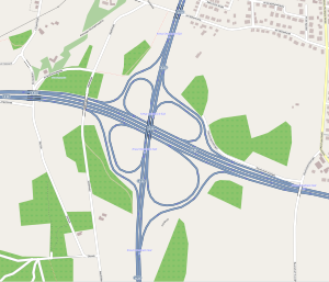
The motorway junction Osnabrück-Süd (abbreviation: AK Osnabrück-Süd ; short form: Kreuz Osnabrück-Süd ) is a motorway junction in Lower Saxony . It connects the federal motorway 30 ( Enschede - Bad Oeynhausen ; E 30 ) with the federal motorway 33 ( Osnabrück - Paderborn ).
It was converted in the 1980s from the former junction of the A 30 to what was then Osnabrück's eastern bypass (today A 33).
geography
The motorway junction is in the urban area of Osnabrück . The closest districts are Nahne , Voxtrup and Schölerberg . The surrounding towns and communities are Georgsmarienhütte and Bissendorf . It is located about 4 km southeast of downtown Osnabrück, about 115 km west of Hanover and about 40 km northwest of Bielefeld .
The Osnabrück Zoo is also in the immediate vicinity . It is located in the middle of the TERRA.vita nature park .
The Osnabrück-Süd motorway junction has junction number 19 on the A 30 and number 9 on the A 33.
Design and state of development
The A 30 in the direction of the Lotte / Osnabrück intersection has four lanes, the A 30 in the direction of Bad Oeynhausen and the A 33 also each have four lanes. The connecting ramps are single-track.
The motorway junction was laid out as a clover leaf .
Traffic volume
The cross is used by around 101,000 vehicles every day. After the gap on the A 33 between Bielefeld and Borgholzhausen has been closed, however, a considerable increase in traffic is to be expected.
| From | To | Average daily traffic volume |
Share of heavy goods traffic |
|---|---|---|---|
| AS Osnabrück-Nahne (A 30) | AK Osnabrück-Süd |
|
|
| AK Osnabrück-Süd | AS Natbergen (A 30) |
|
|
| AS Osnabrück-Fledder (A 33) | AK Osnabrück-Süd |
|
|
| AK Osnabrück-Süd | AS Harderberg (A 33) |
|
Individual evidence
- ↑ Kreuz Osnabrück-Süd. (No longer available online.) Autobahn intersections & Autobahn triangles in Germany, 2011, archived from the original on October 25, 2014 ; Retrieved October 25, 2014 . Info: The archive link was inserted automatically and has not yet been checked. Please check the original and archive link according to the instructions and then remove this notice.
- ↑ Manual traffic census BAB 2015. BASt Statistics, 2015, accessed on September 5, 2017 . (PDF file)

