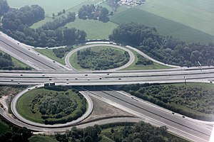
Bielefeld motorway junction
| Bielefeld motorway junction | |
|---|---|
|
|
|
| map | |
| location | |
| Country: | Germany |
| State : | North Rhine-Westphalia |
| Coordinates: | 51 ° 56 '36 " N , 8 ° 32' 34" E |
| Height: | 120 m above sea level NN |
| Basic data | |
| Design type: | Shamrock |
| Bridges: | 1 (motorway) / 5 (other) |
| Construction year: | 1993 |
| Last modification: | 2012 |
| Expansion status until 2011 | |
The motorway junction Bielefeld (abbreviation: AK Bielefeld ; short form: Kreuz Bielefeld ) is a motorway junction in North Rhine-Westphalia in East Westphalia-Lippe . It connects the federal highway 2 ( Oberhausen - Hanover - Berlin ; E 34 ) with the federal highway 33 ( Osnabrück - Paderborn ).
geography
The motorway junction is in the city of Bielefeld . The closest districts are Senne, Sennestadt and Eckardtsheim. It is located about 10 km south of Bielefeld city center, about 65 km east of Münster and about 30 km northwest of Paderborn .
It is also not far from the Eggegebirge nature park and the southern Teutoburg Forest .
The Bielefeld motorway junction has junction number 25 on the A 2 and number 21 on the A 33.
history
The cross is built in the shape of a clover leaf, with the A 2 crossing the A 33 at an angle of approximately 50 °. The first construction phase of the Bielefeld motorway junction with the connection of the A 33 in and from Paderborn was opened to traffic in November 1993. As part of the extension of the A 33 to Ostwestfalendamm in Bielefeld-Brackwede (AS Bielefeld-Zentrum), which began in 2007, the remaining connecting lanes were also completed and opened to traffic on December 5, 2012. The cost of this 6.4-kilometer section was 128 million euros .
Design and state of development
The A 33 has four lanes, the A 2 has six lanes. The connecting ramps are single-track.
The motorway junction was laid out as a clover leaf .
Traffic volume
The cross is used by around 131,000 vehicles every day. After closing the gap on the A 33 between Bielefeld and Borgholzhausen , however, an increase in traffic is to be expected.
| From | To | Average daily traffic volume |
Share of heavy goods traffic |
||||
|---|---|---|---|---|---|---|---|
| 2005 | 2010 | 2015 | 2005 | 2010 | 2015 | ||
| AS Gütersloh (A 2) | AK Bielefeld | 69,900 | 64,200 | 84,300 | 20.5% | 21.2% | 18.3% |
| AK Bielefeld | AS Bielefeld-Süd (A 2) | 88,700 | 90,600 | 89,800 | 19.4% | 18.3% | 19.9% |
| AS Bielefeld-Senne (A 33) | AK Bielefeld | - | - | 39,000 | - | - | 9.2% |
| AK Bielefeld | AS Schloß Holte-Stukenbrock (A 33) | 34,200 | 29,900 | 49,200 | 13.4% | 14.5% | 15.9% |
Individual evidence
- ↑ Construction report on the opening of traffic on November 3, 1993
- ↑ Westfalenblatt: OWL is growing together ( Memento from January 6, 2013 in the web archive archive.today )
- ↑ Manual road traffic census 2005. (PDF) Results on federal motorways. BASt Statistics, 2005, accessed on June 24, 2020 .
- ↑ Manual road traffic census 2010. (PDF) Results on federal motorways. BASt Statistics, 2010, accessed on June 24, 2020 .
- ↑ Manual road traffic census 2015. (PDF) Results on federal motorways. BASt Statistics, 2015, accessed on August 26, 2017 .

