Längentalbach (Nederbach)
| Längentalbach | ||
| Data | ||
| Water code | AT : 2-8-92-86-6 | |
| location | Tyrol , Austria | |
| River system | Danube | |
| Drain over | Nederbach → Ötztaler Ache → Inn → Danube → Black Sea | |
| source | below Wechner- and Hochbrunnachkogel 47 ° 10 ′ 50 ″ N , 10 ° 57 ′ 58 ″ E |
|
| Source height | 2595 m above sea level A. | |
| muzzle | below the Kühtai saddle in the Längental reservoir ( Nederbach ) Coordinates: 47 ° 12 ′ 28 " N , 11 ° 0 ′ 12" E 47 ° 12 ′ 28 " N , 11 ° 0 ′ 12" E |
|
| Mouth height | 1901 m above sea level A. | |
| Height difference | 694 m | |
| Bottom slope | 11% | |
| length | 6.3 km | |
| Catchment area | 9.2 km² | |
| Discharge at the Kühtai A Eo gauge : 9.2 km² Location: 350 m above the mouth |
NNQ (02/27/1981) MNQ 1981–2013 MQ 1981–2013 Mq 1981–2013 MHQ 1981–2013 HHQ (08/23/2005) |
9 l / s 26 l / s 360 l / s 39.1 l / (s km²) 2.94 m³ / s 7.15 m³ / s |
| Reservoirs flowed through | Kühtai storage facility (under construction) | |
The Längentalbach is a left tributary of the Nederbach in the Längental in the Stubai Alps in Tyrol with a length of 6.25 km.
Run and landscape
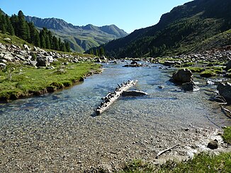
The Längentalbach rises at an altitude of almost 2600 m between the Wechner- and Hochbrunnachkogel and flows first in an easterly, then in a northerly direction through the Längental. At the end of the valley it flows into the Längental reservoir of the Sellrain-Silz power plant group , through which the Nederbach flows.
Hydrology
The natural catchment area of the Längentalbach is 9.2 km², 0.7% of which is glaciated. The highest point in the catchment area is the Sulzkogel at 3,016 m above sea level. A.
The mean discharge at the Kühtai gauge is 0.36 m³ / s, which corresponds to a discharge rate of 39.6 l / (s · km²). The Längentalbach has a very pronounced nivo-glacial runoff regime , which is characterized by high runoffs in summer and low runoffs in winter. The mean monthly mean of the runoff is in the month of June with the most water with 1.18 m³ / s around 37 times higher than in the month of February with the least water with 0.032 m³ / s.
ecology
The Längentalbach is an unregulated mountain stream . Steeper sections with higher flow speeds alternate with wider meanders . Here gravel and sand banks have formed in places , which are repeatedly relocated and washed over. Only a few, special pioneer species can thrive on these dynamic areas. At quieter places have pools formed. The water is the habitat of aquatic mosses (e.g. hygrohypnum ), algae , macrozoobenthos (e.g. fly larvae species) and amphibians . The construction of the Kühtai reservoir will destroy the creek over a length of around 2.4 km.
Individual evidence
- ↑ a b TIRIS - Tyrolean spatial information system
- ↑ a b Wolfgang Gattermayr: The hydrographic regime of the Ötztaler Ache. In: Eva-Maria Koch, Brigitta Verschbamer (Ed.): Climate, Weather, Glaciers in Transition. Alpine Research Center Obergurgl, Volume 3, Innsbruck University Press, Innsbruck 2013, ISBN 978-3-902811-89-9 , pp. 121–155. ( PDF; 3.7 MB )
- ^ A b Ministry for an Austria worth living in (ed.): Hydrographisches Jahrbuch von Österreich 2013. 121st volume. Vienna 2015, p. OG 103, PDF (9.0 MB) on bmlrt.gv.at (2013 yearbook)
- ↑ Helmut Mader, Theo Steidl, Reinhard Wimmer: Discharge regime of Austrian rivers. Contributions to a nationwide river typology. Federal Environment Agency, monographs Volume 82, Vienna 1996, p. 95 ( PDF; 14.7 MB )
- ^ Tiroler Wasserkraft AG (TIWAG), Innsbruck; Kühtai pumped storage power plant Revision 3 - Supplementary statement by the state environmental lawyer (PDF; 7.7 MB)
