
La Ferrière-de-Flée
| La Ferrière-de-Flée | ||
|---|---|---|
|
||
| local community | Segré-en-Anjou Bleu | |
| region | Pays de la Loire | |
| Department | Maine-et-Loire | |
| Arrondissement | Segré | |
| Coordinates | 47 ° 44 ′ N , 0 ° 51 ′ W | |
| Post Code | 49500 | |
| Former INSEE code | 49136 | |
| Incorporation | 15th December 2016 | |
| status | Commune déléguée | |
 Former town hall of La Ferrière-de-Flée |
||

La Ferrière-de-Flée is a town and commune Déléguée in the French community Segre-en-Anjou Bleu with 356 inhabitants (as of January 1 2017) in the department of Maine-et-Loire in the region of Pays de la Loire . The inhabitants are called Ferfléens .
The municipality of La Ferrière-de-Flée was founded on December 15, 2016 with 14 other municipalities, namely Aviré , Le Bourg-d'Iré , La Chapelle-sur-Oudon , Châtelais , L'Hôtellerie-de-Flée , Louvaines , Marans , Montguillon , Noyant-la-Gravoyère , Nyoiseau , Sainte-Gemmes-d'Andigné , Saint-Martin-du-Bois , Saint-Sauveur-de-Flée and Segré merged to form the new municipality of Segré-en-Anjou Bleu . It belonged to the Arrondissement of Segré and the Canton of Segré .
geography
La Ferrière-de-Flée is around 40 kilometers northwest of Angers .
Population development
| year | 1962 | 1968 | 1975 | 1982 | 1990 | 1999 | 2006 | 2013 |
| Residents | 399 | 362 | 332 | 272 | 265 | 262 | 309 | 362 |
| Source: Cassini and INSEE | ||||||||
Attractions
- Sainte-Madeleine church from the 19th century
- Chapel from the 12th century
- Notre-Dame-du-Chêne chapel in Pomme-Poire
- Putifay dolmen, a historic monument since 1990
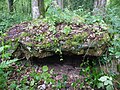
- Megalithic tomb, Monument historique since 1989
- La Ferrière castle from the 14th century, alterations from the 16th century
- La Retiverie Castle

Sainte-Madeleine church

Pomme-Poire Chapel
Megalithic tomb

Putifay dolmen


literature
- Le Patrimoine des Communes de Maine-et-Loire . Flohic Editions, Volume 2, Paris 2001, ISBN 2-84234-117-1 , pp. 1202-1203.