
Le Bourg-d'Iré
| Le Bourg-d'Iré | ||
|---|---|---|
|
||
| local community | Segré-en-Anjou Bleu | |
| region | Pays de la Loire | |
| Department | Maine-et-Loire | |
| Arrondissement | Segré | |
| Coordinates | 47 ° 41 ′ N , 0 ° 58 ′ W | |
| Post Code | 49520 | |
| Former INSEE code | 49037 | |
| Incorporation | 15th December 2016 | |
| status | Commune déléguée | |
| Website | http://www.bourgdire.mairie49.fr/ | |
 Town hall (Mairie) of Le Bourg-d'Iré |
||

Le Bourg-d'Iré is a town and commune Déléguée in the French community Segre-en-Anjou Bleu with 902 inhabitants (as of January 1 2017) in the department of Maine-et-Loire in the region of Pays de la Loire . The inhabitants are called Bourg-d'Iréens .
The municipality of Le Bourg-d'Iré was founded on December 15, 2016 with 14 other municipalities, namely Aviré , La Chapelle-sur-Oudon , Châtelais , La Ferrière-de-Flée , L'Hôtellerie-de-Flée , Louvaines , Marans , Montguillon , Noyant-la-Gravoyère , Nyoiseau , Sainte-Gemmes-d'Andigné , Saint-Martin-du-Bois , Saint-Sauveur-de-Flée and Segré merged to form the new municipality of Segré-en-Anjou Bleu . It belonged to the Arrondissement of Segré and the Canton of Segré .
geography
Le Bourg-d'Iré is located around 40 kilometers northwest of Angers on the Verzée .
Population development
| year | 1962 | 1968 | 1975 | 1982 | 1990 | 1999 | 2006 | 2013 |
| Residents | 978 | 915 | 911 | 851 | 782 | 724 | 784 | 870 |
| Source: Cassini and INSEE | ||||||||
Attractions
- Saint-Symphorien church from the 17th century
- La Douve Chapel
- La Mabouillière castle from the 19th century
- 19th century castle La Douve
- Bellevue Palace

Saint-Symphorien Church
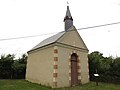
La Douve Chapel

La Mabouillière Castle

La Douve Castle


Personalities
- Frédéric de Falloux du Coudray (1807-1884), cardinal
- Père Marie-Benoît (civil: Pierre Péteul, 1895–1990), clergyman
literature
- Le Patrimoine des Communes de Maine-et-Loire . Flohic Editions, Volume 2, Paris 2001, ISBN 2-84234-117-1 , pp. 1191-1194.