Lake Ngami
| Lake Ngami | ||
|---|---|---|

|
||
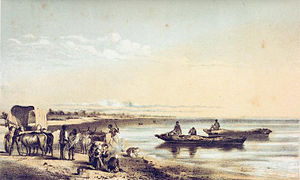
| The lake in 1857 | ||
| Geographical location |
North of the Kalahari |
|
| Tributaries | Okavango → Thauge | |
| Drain | Nhabe → Boteti → Makgadikgadi Salt Pans | |
| Places on the shore | Sehithwa | |
| Data | ||
| Coordinates | 20 ° 28 ′ 0 ″ S , 22 ° 47 ′ 0 ″ E | |
|
|
||
| Altitude above sea level | approx. 930 m | |
| surface | 0 to approx. 240 km² | |
|
particularities |
endorheic , temporarily dry |
|
The Lake Ngami (English: Lake Ngami ) is a lake in Northwest District in Botswana .
geography
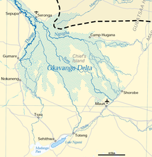
Lake Ngami is located south of the actual Okavango Delta and on the northern border of the Kalahari Desert at around 930 meters above sea level in a depression in the Kalahari Basin. Its area, once 770 km², decreased sharply; the lake is shallow and because of the changing water levels, it has no fixed banks. The shape is roughly oval with the longitudinal axis from northeast to southwest.
The north bank is sandy with individual large trees, the south bank is characterized by low hills. The area of the lake varies in size - also because of the semi-arid climate. The highest water level is reached long after the rainy season because of the low flow speed in the delta .
Close to the north bank are the town of Sehithwa and numerous scattered settlements , some of whose inhabitants live from fishing - but fishing has been temporarily prohibited since 2017. Tourism, for example for bird watchers, plays a minor role.
Immediately southwest of the lake is the Madongo Pan salt pan.
Hydrology
From the northwest, the Thauge brings water from the Okavango delta; when the water level is high, it flows over the Nhabe into the Boteti (also called Botletle ), which is around 600 kilometers long and ends in the Makgadikgadi salt pans .
While Lake Ngami usually measures up to 50 square kilometers, it expanded to around 115 square kilometers in 2009 after heavy rainfall in Angola , and in 2011 even to 240 square kilometers.
The lake is endorheic , so it has no outflow to the sea.
history
Lake Ngami is one of the remains of the prehistoric Lake Makgadikgadi .
In the 1820s, BaTawana settled there and were the first residents of the lake to keep livestock. In 1849 Lake Ngami was sighted as the first Europeans by a group around William Cotton Oswell and David Livingstone . Livingstone estimated the circumference to be around 275 kilometers. Lured by Livingstone's reports, the lake became the destination of numerous explorers and adventurers. Karl Johan Andersson reached the lake in 1853, Hans Schinz in 1886 , and in 1890 it was navigated by the Austrian geologist Eduard Fleck . Also Siegfried Passarge explored Lake Ngami.
Shortly after Livingstone's voyage, the water level sank because the upper reaches of the Thauge was blocked by numerous papyrus rafts that had grown in the river bed. Most of the cattle died as a result, and a malaria epidemic broke out among the residents . In 1875 a group of Boers reached the lake on the first Dorsland trek . Their path is also known as the Groot Ngami Trek .
In 1896 the lake dried out completely for the first time - as far as historically guaranteed. Only in 1953 did the Taughe carry so much water that the lake was filled again. The flood brought many fish into the lake, and numerous species of animals, especially birds, settled on and in the water. However, the dung of the grazing animals led to such great growth of blue-green algae and phytoplankton that most fish species became extinct. Only the cichlid species Oreochromis andersonii and Oreochromis macrochir as plankton eater and a barbus species that can feed on cow dung survived for the time being. In 1965/1966 the lake dried up again. In 1979 and 1989 the water level was exceptionally high and large populations of numerous bird species were recorded.
In 2017, the government banned the export of dried fish from the lake for a year after fishing had previously been restricted.
Flora and fauna
The bank vegetation consists of acacias , palm trees , baobab and sterculia, among others .
The lake is a habitat for many birds, including pelicans , flamingos , ibises , great egrets and the blood- billed weaver ( Quelea quelea ). Fish live in the lake, including a species of barbus that can survive in the mud if the lake dries up. There are numerous flies and mosquitoes depending on the water level.
Others
The methane lake Ngami Lacuna on the Saturn moon Titan is named after the lake , which, like the Ngami lake, is endorheic.
literature
- Charles John Anderson : Lake Ngami. Struik, Cape Town 1967 (reprint).
- Creina Bond: Lake Ngami. In: Peter Johnson, Anthony Bannister: Okavango: sea of land, land of water. 9th edition. Struik, Cape Town 1988, ISBN 0-86977-086-1 , pp. 41-45.
- Lake Ngami . In: Meyers Großes Konversations-Lexikon . 6th edition. Volume 14, Bibliographisches Institut, Leipzig / Vienna 1908, p. 611 .
Web links
- Joshua Comrade Buru: Revisiting Hydrology of Lake Ngami in Botswana. researchgate.net, January 2018 (English)
- Andrew S. White: Living the Overlander's Dream, 24/26: Lake Ngami ( Youtube )
- Popis: Ngami lake ( Youtube )
Individual evidence
- ↑ a b Lake Ngami at britannica.com (English), accessed October 3, 2014
- ↑ Creina Bond: The Pans. In: Peter Johnson, Anthony Bannister: Okavango: sea of land, land of water. 9th edition. Struik, Cape Town 1988, ISBN 0-86977-086-1 , p. 33.
- ↑ Lake Ngami 2011 (English), accessed September 23, 2015
- ↑ a b Creina Bond: Lake Ngami. In: Peter Johnson, Anthony Bannister: Okavango: sea of land, land of water. 9th edition. Struik, Cape Town 1988, ISBN 0-86977-086-1 , p. 41.
- ↑ Carl Ganzert: Memories from my life. (1934), p. 19 - PDF file (1.3 MB)
- ↑ Creina Bond: Lake Ngami. In: Peter Johnson, Anthony Bannister: Okavango: sea of land, land of water. 9th edition. Struik, Cape Town 1988, ISBN 0-86977-086-1 , p. 42.
- ↑ a b Creina Bond: Lake Ngami. In: Peter Johnson, Anthony Bannister: Okavango: sea of land, land of water. 9th edition. Struik, Cape Town 1988, ISBN 0-86977-086-1 , p. 44.
- ↑ Location Ngami near birdlifebotswana ( Memento from July 26, 2015 in the Internet Archive ) (English)
- ↑ Botswana: government fishing ban cuts lifeline to impoverished villagers. Daily Maverick, October 6, 2017, accessed October 7, 2017
- ↑ Ngamisee in the Gazetteer of Planetary Nomenclature of the IAU (WGPSN) / USGS


