
Langensteinbach (Karlsbad)
|
Langensteinbach
Karlovy Vary municipality
|
|
|---|---|
 |
|
| Height : | 244 m |
| Area : | 14 km² |
| Residents : | 6361 (Aug 31, 2018) |
| Population density : | 454 inhabitants / km² |
| Incorporation : | 1st September 1971 |
| Postal code : | 76307 |
| Area code : | 07202 |
 Location of Langensteinbach in Karlsbad
|
|
 View over Langensteinbach
|
|
Langensteinbach is a part of the municipality of Karlsbad , which was named in 1971 after the spa built in 1719.
history
Langensteinbach that in the valley of earlier than Steinbach referred Bock Bach is located, was first mentioned in 1197. In the 18th century it was famous as a health resort or royal bath. Margrave Karl Wilhelm von Baden built a bathing building below the Barbara Chapel in 1719 . On September 1, 1971, Langensteinbach merged with four other municipalities to form the new municipality of Karlsbad.
Religions
As part of the margraviate of Baden-Durlach , Langensteinbach was evangelical. Today in Langensteinbach five Christian communities are represented: the Protestant and Catholic church, the denominational Bible conference center Langensteinbach height ( LaHoe ), the evangelical Bibelheim Bethany and the New Apostolic Church.
Buildings
- The Protestant Ludwig Church has had an organ by Johann Ferdinand Balthasar Stieffell since 1871 .
- Above the village is the residue of a tower castle , the castle Langensteinbach , also called Roman Tower,
- in the immediate vicinity of the later St. Barbara chapel ruin .
- The so-called Haus Conrath was named “ Monument of the Month June 2006” by the Monument Foundation Baden-Württemberg .

Ludwigskirche in Weinbrenner style
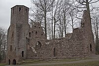
Ruins of the St. Barbara Chapel

Ruins of the "Roman Tower"


traffic
Langensteinbach has three stations on the Busenbach – Ittersbach railway line , which are served by the S11 of the Karlsruhe Stadtbahn :
- Schießhüttenäcker
- Langensteinbach train station
- Langensteinbach St. Barbara
Others
The SRH Klinikum Karlsbad-Langensteinbach is located in the village .

Web links
- Article Langensteinbach in the Stadtwiki Karlsruhe
- Langensteinbach's Weinbrenner Church at badischewanderungen.de
- LaHoe Bible Conference Center
- 360 degree spherical panorama from the Rathausmarkt
Individual evidence
- ^ Federal Statistical Office (ed.): Historical municipality directory for the Federal Republic of Germany. Name, border and key number changes in municipalities, counties and administrative districts from May 27, 1970 to December 31, 1982 . W. Kohlhammer, Stuttgart / Mainz 1983, ISBN 3-17-003263-1 , p. 476 .