
Auerbach (Karlsbad)
|
Auerbach
Karlovy Vary municipality
|
|
|---|---|
 |
|
| Height : | 250 m |
| Area : | 5.31 km² |
| Residents : | 1818 (Aug 31, 2018) |
| Population density : | 342 inhabitants / km² |
| Incorporation : | 1st September 1971 |
| Postal code : | 76307 |
| Area code : | 07202 |
 Location of Auerbach in Karlsbad
|
|
.svg) Map of Auerbach (Karlsbad)
|
|
Auerbach is a district of the municipality of Karlsbad in the district of Karlsruhe .
Geography and name
The place on the northern edge of the Black Forest is on the Alb-Pfinz plateau and is one of 5 districts of the municipality of Karlsbad . The neighboring towns are Mutschelbach (Karlsbad) in the north, Nöttingen ( Remchingen ) in the northeast, Dietenhausen and Ellmendingen (both municipality of Keltern ) in the east, Weiler (also Keltern) in the south-southeast, Ittersbach (Karlsbad) in the south and Langensteinbach (Karlsbad) in the west . At a length of about 4.5 kilometers, which is district of the town of Auerbach flows through the at Ittersbach springs, Auerbach crosses from southwest to northeast and then at Nöttingen in the fledgling Pfinz flows, which up to this point only about one-sixth of their The way to the Rhine .

Winter landscape at the Auerbach near Auerbach 
Auerbach in winter

Place name and its meaning
Whether the village is named after the water of the same name that flows through it or the latter after the locality can no longer be clearly determined today.
In the course of time the place (and probably also the water) was mentioned in different documents with different names and spellings. In the oldest surviving documentary mention from 1278 there is talk of "Urbach". From the 15th and 17th centuries "Awrbach", "Awerbach" and, as early as 1614, "Aurbach" have been handed down.
The first-mentioned spelling suggests a derivation from the aurochs , which was known to the Germanic peoples as Ur . The basic word -bach in turn suggests the Franks as the originator of the name. Place names of the Alemanni who preceded them in the area usually have the suffix -ingen . So it is very likely that Auerbach was settled before said documentary mention.
history
The first traces of human settlement life in the local area go back to the eighth century BC. In 1897 the remains of a Celtic barrow of the Helvetii tribe were discovered in the Auerbach district .
Roman times
When the Roman emperor Caesar Vespasian Augustus expanded his sphere of influence in the 1st century AD, Auerbach also became part of the Roman Empire (Imperium Romanum) . It belonged to the tenth country and was part of the province Germania Superior . This could be proven on the basis of relics from that time in the Auerbach district.
Thus, in the Won in the north Auerbach, remains that Hermann reason (see map), Roman road have been preserved, which of Strasbourg (Argentorate) about Ettlingen and Pforzheim (Portus) to Cannstatt led.
In 1936 the remains of a Roman country estate were found in Auerbach , which, according to local archaeological finds, was probably taken by the Alemanni despite extensive security measures .
In 1937, the remains of a Roman inn were found in the legendary Gewann Schlossheck, where the new stadium of the local football club is located today.
Other smaller pieces of evidence were found on site and in the vicinity.
The mining site for the local red sandstone, popularly known as the Roman quarry, not far from the Millions Route (see map), could also come from the time of the emerging craft in the 19th century.
German times
In the second half of the 3rd century AD, the Alemanni defeated the Romans in the tithe country and took over the "land between the Limes and the Rhine". It is not certain when these were subject to the Franks in Auerbach ; What is certain, however, is that the latter soon challenged the Alemanni for their newly won land and won. In 496 AD the Alemanni in Zülpich in the Rhineland were completely defeated and had to retreat to the area south of the Murg .
First documentary mention
The oldest, still preserved documentary mention of Auerbach, at that time still called Urbach , dates from November 28, 1278. This document, kept in the Badisches Generallandesarchiv in Karlsruhe, dealt with disputes regarding territorial claims between the Lords of Remchingen and the Herrenalb Monastery . At that time Auerbach was administered by the Lords of Remchingen , but belonged to the Counts of Eberstein . Only 5 years later Auerbach got through Count Otto II. Von Eberstein as a dowry from Kunigunde von Eberstein to the Margrave Rudolf I of Baden and thus became Baden for a short time. However, when he died another 5 years later in 1288, his heir, Margrave Friedrich II of Baden, sold the area on which Auerbach was located to the Herrenalb monastery .
Auerbach becomes Baden
About 200 years after the complete acquisition by the Herrenalb Abbey , a period of frequent changes of ownership followed. In the meantime, Auerbach even went to Württemberg as an exclave for about 70 years before Margrave Ernst Friedrich von Baden-Durlach , ending the sacrilege and lavish lifestyle of his cousins, took over and restructured the Margraviate of Baden-Baden . As part of the proceeds from the sale of the offices of Altensteig and Liebenzell to Duke Friedrich I of Württemberg in 1603, he received, among other things, Auerbach back. From now on Auerbach was part of Baden again.
Waldensians and Huguenots
A period of heavy losses followed. The Thirty Years' War and the simultaneous plague decimated Auerbach's population enormously. It is said that Auerbach, which had around 200 inhabitants before the war, only had 3 inhabitants in 1648. The Huguenot and Waldensian refugee families, who settled in the village at the turn of the 17th and 18th centuries, were very welcome. Known as hardworking and learned, they were warmly welcomed and enjoyed one or the other privilege, such as freedom of religion , their own village administration, their own French-speaking pastor and teacher. In return, as in the rest of Baden, they also helped Auerbach get back on its feet.
Before the First World War
The enormous poverty at the end of the 18th and beginning of the 19th century led to emigration, for example to West Prussia, or to learn a trade . Hand weavers and stone breakers found themselves in Auerbach as well as the first commuters and market-goers, i.e. farmers who sold their products in the markets in the area, for which they covered sometimes strenuous and long distances using the simplest means of transport.
The world wars
The two world wars, the global economic crisis of the 1920s and inflation did not stop at Auerbach either. However, war victims, unemployment and poverty strengthened the cohesion in the village and made survival possible in the first place. The refugees and displaced persons who came to Auerbach after the Second World War mainly from the former eastern regions, however, also promoted the infrastructural upswing and expansion of the town in the years that followed .
Karlovy Vary municipality
In the course of the municipality reform , Auerbach lost its status as an independent municipality on September 1, 1971 and became one of five districts of the newly founded municipality of Karlsbad , which in addition to Auerbach also includes Mutschelbach , Ittersbach , Spielberg and Langensteinbach . The municipality owes its name to the favorite place of residence of Margrave Karl-Friedrich von Baden , his princely bath in the most populous and central district of Langensteinbach .
Auerbach today

"Talblickhalle" gymnasium and event hall 
Evangelical Church Auerbach 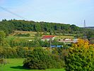
View of the new TSV Auerbach stadium in the Gewann Schlossheck
_01.jpg)

_01.jpg)
Auerbach is one of the smaller districts, but still has its own town hall , a kindergarten , a primary school and a gymnasium and event hall . a. is used for school sports for elementary school students . Auerbach's soccer club, TSV Auerbach, received a new sports field in 2005 in the Gewann Schlossheck on the north-eastern outskirts. In the area of the old sports field, the new building area "Im Thäle" was developed.
swell
- ↑ See: Max Baldinger and Karlsbad-Auerbach: 700 Years of Auerbach 9.-12. June 1978. Macklotsche Druckerei Ettlingen, 1978, p. 26 f.
- ↑ quoted from: Max Baldinger and Karlsbad-Auerbach: 700 years Auerbach 9.-12. June 1978. Macklotsche Druckerei Ettlingen, 1978, p. 23.
- ↑ See: Max Baldinger and Karlsbad-Auerbach: 700 Years of Auerbach 9.-12. June 1978. Macklotsche Druckerei Ettlingen, 1978, pp. 20-64
- ^ Federal Statistical Office (ed.): Historical municipality directory for the Federal Republic of Germany. Name, border and key number changes in municipalities, counties and administrative districts from May 27, 1970 to December 31, 1982 . W. Kohlhammer, Stuttgart / Mainz 1983, ISBN 3-17-003263-1 , p. 476 .
literature
- Max Baldinger and Karlsbad-Auerbach: 700 years of Auerbach 9.-12. June 1978. Macklotsche Druckerei, Ettlingen 1978.