
Lantau Peak
| Lantau Peak 爛頭 山
Fung Wong Shan (official)
鳳凰 山 (official) |
||
|---|---|---|
 Lantau Peak with the " Big Buddha ", 2006 |
||
| height | 934 m | |
| location |
Lantau Island ; Hong Kong , China |
|
| Coordinates | 22 ° 14 '59 " N , 113 ° 55' 16" E | |
|
||
| rock | Volcanic rock | |

The Lantau Peak , officially called Fung Wong Shan in Chinese , is at 934 meters above sea level the highest natural elevation on the island of Lantau and the second highest elevation in Hong Kong - the highest elevation Taimoshan 957 m. According to the "Association of Country Park Friends", Lautau Peak is one of the ten most popular excursion destinations in Hong Kong. The 2005 Opened trail Wisdom Path - 心經簡林 - ( German Wisdom Path - formerly Heart Sutra Inscription - " Heart Sutra - inscription " ⊙ ) located in the popular Lantau North Country Park on the island.
designation
The common English name Lantau Peak comes from the colloquial name of the local population for this peak, the literal "mountain of the rugged peak" - Chinese 爛頭 山 / 烂头 山 , Pinyin Làntóu Shān , W.-G. Lan T'ao Shan , Jyutping Laan 6 tau 4 Saan 1 , English Ragged Peak - "rugged mountain peak" - is. Due to linguistic misunderstandings in communication with the first English officials of the colonial government , the official English name was included in the maps. In everyday use today, Hong Kong citizens mostly use the official Chinese name - Fung Wong Shan ( 鳳凰 山 / 凤凰 山 , Fènghuáng Shān , Jyutping Fung 6 wong 4 Saan 1 - " Phoenix - Mountain") - as the name, while internationally the unofficial name Lantau Peak continues to be more common.

Unofficially, the Lantau Peak in Chinese as " parrot Meis Schnabelsberg " - 鴉雀口山 / 鸦雀口山 , Yāquèkǒu Shān , Jyutping Aa 1 zoek 3 hau 2 Saan 1 - known as the two Gipel like a bird's beak against the sky opens.
Geographical location
The mountain is located in the southern part of the island near the Tian Tan Buddha , the Po Lin Buddhist monastery and the Ngong Ping 360 cable car . It consists of two peaks, of which the main peak Fung Feng ( 鳳 峰 / 凤 峰 , Fèng Fēng , Jyutping Fung 6 Fung 1 - "male phoenix peak") and the other peak of Wong Feng ( 凰 峰 , Huáng Fēng , Jyutping Wong 4 Fung 1 - "female phoenix peak"). Both names of the mountain peaks refer to a pair of birds belonging to the "Chinese phoenix" - Fenghuang . A little below the summit is the Tsam Chai Au at 810 meters above sea level . On the summit plateau there is a refuge for hikers and a triangulation point .
climate
According to the Köppen and Geiger climate classification, the climate of the Lantau Peaks belongs to the subtropical mountain climate - more precisely climate group C , Cwb type - or to the ocean climate - more precisely Cfb type. Due to the altitude, there is a strong wind at Lantau Peak all year round. Fog at the summit in every season is not uncommon. In the winter months the temperature can drop below zero degrees Celsius - <0 ° C. In the months of summer, the maximum average temperature rises above 24 degrees Celsius . In spring it is cold and humid, while in autumn a cold, dry climate prevails. There is no weather station at the summit of Lantau Peak (934 m, ⊙ ) , so the data from the weather station on the nearby Ngong Ping plain (593 m, ⊙ ) is used as a reference.
|
Climatic data for Lantau Peak 1
Source: Hong Kong Observatory
|
photos
- Lantau Peak - 鳳凰 山

Mist-shrouded summit - Lantau Peak, 2017

Hiking trail on Lantau Peak, 2007

Height information -
934 m asl , 2017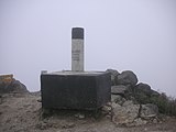
Triangulation point on the summit, 2017

Paifang for sunrise show A , 2010

Platform Wisdom Path, 2011

Wisdom Path, 2007

Starry sky over Lantau Peak, 2014


- annotation
See also
- Castle Peak (Hong Kong)
- Checkerboard Hill
- Lion Rock
- Mount Parker (Hong Kong)
- Tai Mo Shan
- Victoria Peak (Hong Kong)
Web links
- Lantau Peak - hiking route on www.walkonhill.com (Chinese, English)
- Lantau Peak - hiking map at www.discoverhongkong.com (Chinese, English)
Individual evidence
- ^ Lantau Volcanic Group (undifferentiated) - Jlu. In: cedd.gov.hk. The Civil Engineering and Development Department, accessed June 23, 2020 (Chinese, English).
- ↑ 郊野 公園 之 友 會 - “Association of Country Park Friends”: 「香港 十大 勝景 選舉」 - “Choice of the ten most popular tourist destinations in Hong Kong” ( Memento from December 13, 2007 in the Internet Archive ). In: focp.org.hk, accessed June 23, 2020 (Chinese).
- ^ Lantau North - Lantau North Country Park & Extension. In: afcd.gov.hk. Agriculture, Fisheries and Conservation Department, accessed August 1, 2020 (Chinese, English).
- ^ Lantau South - Lantau South Country Park. In: afcd.gov.hk. Agriculture, Fisheries and Conservation Department, accessed June 23, 2020 (Chinese, English).
- ^ The Commerce and Economic Development Bureau of Hong Kong - Tourism Commission: Major Tourism Projects - Completed - The Wisdom Path (formerly known as the Heart Sutra Inscription). In: tourism.gov.hk. Retrieved June 23, 2020 (Chinese, English).
- ↑ am 去玩 [戶外] 鳳凰 絕 嶺. In: archive.am730.com.hk. October 18, 2013, accessed July 25, 2020 (Chinese, AM Leisure - Outdoors - Fenghuang Peak).
- ↑ 山 名 (包括 常用 名 , 別名 , 土 名 , 英名 , 及 已 襲用 之 錯誤 山 名) - "Mountain names (including common designation, secondary designation, local designation, English designation and adopted incorrect designation of the mountains)". In: henrilaw.com. Hippo Hiking Team, accessed June 23, 2020 (Chinese).
- ↑ Learn Thai: Learn Thai ------ 梁 太 - 鳳凰 之 顛 - 黑 葉 伴遊 篇 - "Learn Thai ------ 梁 太 - Fenghuang Summit - Schwarzblatt's Travel Chapter". In: learnthai.blogspot.com. Retrieved June 23, 2020 (Chinese).
- ^ The Hong Kong Tourism Board (HKTB): The Big Buddha and Po Lin Monastery. In: discoverhongkong.com. Retrieved June 23, 2020 (Chinese, English).
- ^ A b Information of Weather Station. In: Hong Kong Observatory - HBO. Retrieved on July 26, 2020 (Chinese, English, geographic coordinates for the Ngong Ping weather station).
- ↑ a b Monthly Mean Temperature (° C) at Ngong Ping. In: Hong Kong Observatory - HBO. Retrieved July 26, 2020 (Chinese, English).