Tai Mo Shan
| Tai Mo Shan 大帽山 |
||
|---|---|---|
|
Tai Mo Shan, 2008 |
||
| height | 957 m | |
| location |
|
|
| Coordinates | 22 ° 25 ′ 0 ″ N , 114 ° 7 ′ 0 ″ E | |
|
|
||
| Type | extinct volcano | |
| rock | tuff | |
The Tai Mo Shan ( Chinese 大帽山 , Pinyin Dàmào Shān , Jyutping Daai 6 mou 6 Saan 1 - "Big Hat Mountain") is the highest point in Hong Kong at 957 m . Due to the homophonic pronunciation in Cantonese , the highest mountain in the Special Administrative Region is colloquially known by the local citizens of Hong Kong as the “Great Fog Mountain ” ( 大霧 山 / 大雾 山 , Dàwù Shān , Jyutping Daai 6 mou 6 Saan 1 - “ Fog Mountain ”).
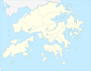
It is located in the 1,440 hectare (14.40 km²) Tai Mo Shan Country Park ( 大帽山 郊野 公園 / 大帽山 郊野 公园 ), one of the 24 landscape protection parks ( 郊野 公園 / 郊野 公园 , English country park ) in the entire area from Hong Kong. The Tai Mo Shan is located on the border between the districts of Tsuen Wan and Yuen Long , partly also in the district of Tai Po , fairly central in the New Territories and therefore quite far from the city center on Hong Kong Island . The mountain is a popular hiking destination and the only place in Hong Kong where the air temperature can drop below freezing. There is a transmitter or meteorological station of the Hong Kong Observatory on the summit .
photos
Hong Kong Observatory weather radar
Serpentines to Tai Mo Shan
See also
Web links
- Official Website - Tai Mo Shan Country Park (Chinese, English)
Individual evidence
- ^ The Government of the Hong Kong Special Administrative Region - Survy and Maping Office - Lands Department: Hong Kong Geografic Data. ( PDF file; 951 kB) In: www.landsd.gov.hk. January 2018, accessed December 15, 2018 (Chinese, English).


