
Castle Peak (Hong Kong)
| Castle Peak
Tsing Shan
青山 |
||
|---|---|---|
 Castle Peak - in the foreground Tuen Mun , 2005 |
||
| height | 583 m | |
| location |
|
|
| Coordinates | 22 ° 23 '18 " N , 113 ° 57' 12" E | |
|
||
| rock | granite | |

The Castle Peak ( Chinese 青山 , Pinyin Qīng Shān , Jyutping Cing 4 Saan 1 , Cantonese Tsing Shan ), historically also Pui To Shan ( 杯 渡 山 , Bēidù Shān , Jyutping Bui 1 dou 6 saan 1 ), is a mountain in the northwest New Territories in Hong Kong . It is 583 m high and is located in the Tuen Mun district .
geography
Castle Peak is about 2.5 km southwest of downtown Tuen Mun and about equidistant north of Castle Peak Bay, which is named after it. Immediately adjacent is a restricted military area and training area. There is a radar station and a TV transmitter on the summit. Castle Peak serves as the namesake for Castle Peak Hospital A , Castle Peak Road B with 51.5 km the longest street in Hong Kong, Castle Peak Bay C with Castle Peak Beach D in Tuen Mun and originally Tuen Mun New Town which was named as Castle Peak New Town in plans . (see also New Towns in Hong Kong )
The region is an ecological refuge for Hong Kong's butterfly population . Castle Peak has been protected as a Site of Special Scientific Interest since 1980 . However, it is not part of a country park, which is due to the military use of the Castle Peak hinterland region . There is a site on the firing range of the Hong Kong Police and the People's Liberation Army - the Tsing Shan Firing Range E .
At the foot of Castle Peak is Tuen Muns Sun Yat Sen Garden F , ⊙ - in memory of the Chinese revolutionary leader in Hong Kong near the listed "Red House" from the 1920-1930s, a former residence of Sun Yat Sens and his entourage.
Names
Yeung Hang Shan ( 羊 坑山 - "sheep pit hill") appears as a historically documented name of the mountain , the village of Yeung Siu Hang ( 羊 小坑 ) nearby is still a reference to this name. Later the mountain is also referred to as the "holy hill" ( 聖山 ) and Tuen Mun Shan ( 屯門 山 - "camp gate mountain , stationing gate mountain "). The latter name refers to soldiers of a garrison town ( 屯門 軍 鎮 - "Tuen Mun garrison town") who were sent by the emperor to Castle Peak during the Tang Dynasty (618-907) to use the land economically and to counter the coast Defend pirate attacks. At the time of the Song (960–1279), Emperor Song Taizu gave this mountain the name Sui Ying Shan - 瑞 應 山 . The Castle Peak ( 青山 ) and Kau Keng Shan ( 九 逕山 - "nine-path mountain") together form a "gate" ( 門 ) at the valley of the mountain ranges, which can also be seen as the derivation of the place name of the former garrison location Tuen Mun - 屯門 - "Stationing (of soldiers) at the gate" used.
The current Chinese name Tsing Shan ( Pinyin Qing Shan ) - 青山 - can be translated as "green hill". In the past, this name was explained by the fact that Castle Peak was still overgrown with grass in winter, while the vegetation on the neighboring hills had already dried up. Today, however, the vegetation has largely receded and the granite rock is visible.
The name Pui To Shan ( 杯 渡 山 ), which goes back to the Buddhist Zen monk Pui To Sim Shi H ( 杯 渡 禪師 ), has also been in use since 428 . There are many legends about him, but what most of them have in common is that he traveled as a poor nomad B. did not adhere to Buddhist food rules. His only possessions were a rice basket and a wooden bowl ( 杯 , bēi , Jyutping bui 1 ). Because of his appearance, he was denied a ferry crossing on the Kwa Po River. He is therefore said to have crossed the sea in his bowl and eventually stranded at Castle Peak. Nothing is known about his further life. The founding of the Tsing Shan Monastery ( 青山 禪院I , also 青山 寺 , English Tsing Shan Monastery ) goes back to this story, although other sources only speak of the worship of Buddha on Castle Peak in 954, when a soldier carved a figure and deposited in a cave on Castle Peak. There is also a village called Tsing Shan Tsuen ( 青山 村 'Green Hill Village' , ⊙ ) at the eastern foot of the mountain.
history
How long the monastery founded by Pui To was continued by other monks after his death is not known. The latest during the reign Daoguangs (1820-1850, Qing Dynasty ) but built Taoists a new monastery at this point, they Tsing Wan Kwun J called. However, it was only popular with pilgrims for a relatively short time and was soon abandoned. In 1918 a Buddhist monastery was founded again. On the initiative of the then governor Cecil Clementi , an archway was built on the path to the monastery in 1929. The summer house Clementi Arbor was built in honor of Clementi .
photos
- Castle Peak surroundings

Hiking trail - start, 2012

Castle Peak Hiking Trail, 2008
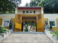
Tsing Shan Monastery - Entrance Gate, 2011

Tsing Shan Monastery - Paifang Gate, 2009

Sunset near the summit - Castle Peak, 2019

Castle Peak - view from Tung Chung , 2011
.jpg)


- annotation
See also
- Checkerboard Hill
- Lantau Peak
- Lion Rock
- Mount Parker (Hong Kong)
- Tai Mo Shan
- Victoria Peak (Hong Kong)
Web links
- Castle Peak hiking route on www.walkonhill.com (Chinese, English)
- Castle Peak hiking route at www.canon.com.hk (Chinese, English)
Individual evidence
- ↑ Planning Department, September 2017: Figure 3: Sites of Special Scientific Interes ( Memento from October 25, 2018 in the Internet Archive ). In: www.pland.gov.hk, accessed on June 22, 2020.
- ↑ Luis Liu: Public invited to watch PLA live-fire drill for 1st time. In: South China Morning Post . July 4, 2015, accessed on July 29, 2020 .
- ↑ Kimmy Chung, Jeffie Lam: Building on 'Grand Canyon' could help solve Hong Kong's housing woes, unfortunately the People's Liberation Army got there first. In: South China Morning Post . July 2, 2018, accessed June 24, 2020 .
- ↑ Ho, Lun: Hong Kong's Grand Canyon Castle Peak Basin. In: likealocalguide.com. July 2, 2018, accessed June 24, 2020 .
- ↑ Hong Kong Government Press Release - Firing practice for February 2019 - "„ 政府 新聞公報 - 二 ○ 一 九年 二 月份 射擊 練習 ". In: www.info.gov.hk. January 28, 2019, accessed on July 29, 2020 (Chinese, English).
- ↑ MIL-OSI Asia-Pac: Firing practice for August 2020. In: foreignaffairs.co.nz. July 27, 2020, accessed on July 29, 2020 .
- ↑ Area map - planning area L / TM40 / 1P. ( PDF file; 3.3 MB) In: www.pland.gov.hk. July 27, 2020, accessed on July 29, 2020 (English, map section L / TM31 / 1H - Tsing Shan Tsuen).
- ^ West New Territories Landfill Extensions Feasibility Study. ( PDF file; 2.9 MB) In: www.pland.gov.hk. July 27, 2020, accessed on July 29, 2020 (English, Tsing Shan Firing Range).
- ↑ 青山 禪院 - 杯 渡 禪師 廟 - "Tsing Shan Monastery - Temple of the Zen Master Pui To". In: www.fushantang.com. Retrieved July 29, 2020 (Chinese).
- ^ A b S. F. Balfour: Hong Kong before the British (= Journal of the Royal Asiatic Society Hong Kong Branch . Volume 10 ). 1970, ISSN 1991-7295 , pp. 134–179 (English, scan [PDF; accessed November 7, 2018]).
- ↑ a b c Sung Hok-P'ang: Legends and Stories of the New Territories: Ts'ing Shaan 青山 or Castle Peak (= Journal of the Royal Asiatic Society Hong Kong Branch . Volume 28 ). 1988, ISSN 1991-7295 , pp. 76–85 (English, scan [PDF; accessed November 7, 2018]).
- ↑ Castle Peak: Hong Kong's Canyon. In: www.inhkmagazin.com. January 1, 1999, accessed November 7, 2018 .