Le Locheur
| Le Locheur | ||
|---|---|---|
|
|
||
| local community | Val d'Arry | |
| region | Normandy | |
| Department | Calvados | |
| Arrondissement | Caen | |
| Coordinates | 49 ° 6 ′ N , 0 ° 33 ′ W | |
| Post Code | 14210 | |
| Former INSEE code | 14373 | |
| Incorporation | January 1, 2017 | |
| status | Commune déléguée | |
 Mairie 's former parish |
||
Le Locheur ( ) is a former French commune with the last 267 inhabitants (as of 1 January 2013) in the department of Calvados in the region of Normandy . It belonged to the arrondissement of Caen and the canton of Aunay-sur-Odon .
The municipality of Le Locheur merged with Noyers-Missy and Tournay-sur-Odon on January 1, 2017 to form the Commune nouvelle Val d'Arry .
geography
Le Locheur is located around 16 km southwest of Caen .
The municipality was surrounded by Noyers-Missy in the north, Bougy in the east, Vacognes-Neuilly in the southeast and south, and Tournay-sur-Odon in the southwest and west.
Population development of the former municipality
| year | 1793 | 1836 | 1876 | 1926 | 1946 | 1968 | 1990 | 2016 |
| Residents | 262 | 404 | 306 | 178 | 163 | 188 | 242 | 267 |
| Source: Cassini, EHESS and INSEE | ||||||||
Attractions
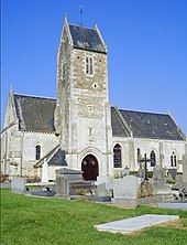
- Saint-Jacques church from the 13th century, monument historique since 1928
Web links
Commons : Le Locheur - collection of images, videos and audio files
- General information about Le Locheur on communes.com ( French )
Individual evidence
- ↑ Le Locheur - Cassini
- ^ Church of Saint-Jacques in the Base Mérimée of the French Ministry of Culture (French)

