
Lehngrundbach
| Lehngrundbach | ||
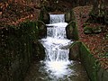
 The Lehngrundbach in the Lehngrund |
||
| Data | ||
| location |
Spessart
|
|
| River system | Rhine | |
| Drain over | Lohr → Main → Rhine → North Sea | |
| source | in the Great Alder Fountain 50 ° 2 ′ 54 ″ N , 9 ° 33 ′ 47 ″ E |
|
| Source height | 419 m above sea level NHN | |
| muzzle | at the Rote Mühle in the Lohr coordinates: 50 ° 1 '9 " N , 9 ° 32' 44" E 50 ° 1 '9 " N , 9 ° 32' 44" E |
|
| Mouth height | 171 m above sea level NHN | |
| Height difference | 248 m | |
| Bottom slope | 62 ‰ | |
| length | 4 km | |
| Catchment area | 5.5 km² | |
 The right branch of the Lehngrundbach (in front) flows into the branched Lohr |
||
The Lehngrundbach or Lehngrundgraben is a left, periodic tributary of the Lohr in the Main-Spessart district in the Bavarian Spessart .
course

The Lehngrundbach rises from the Großer Erlenbrunnen on the Gerberg (443 m) near the Katharinenbildes . The addition is added to the name of this spring to distinguish it from the Kleiner Erlenbrunnen , which flows north to the Sindersbach near the Langenprozelten pumped storage power station .
The flowing south spring water of the Great alder fountain trickles in the summer often completely so that the Lehngrundbach then only from the further down the valley in Lehngrund located Lehnbrunnen ⊙ leads water. When entering the Lohr Valley, the water passes under the route of the Main-Spessart Railway and the B 276 and branches off at the Rote Mühle . The right arm bends to the northwest and flows into the Lohr itself, the left arm is fed to the Lower Auwiesengraben .
See also
Web links
Individual evidence
flowing Lehngrundbach

dry Lehngrundbach

