
Lenbrunnen

The Lenbrunnen is the oldest surviving spring fountain in the city of Bern . It is located in the old town of Bern in the building at Postgasse 68, entrance via the State Chancellery or Lenbrunnengässli . The well system is no longer in operation and is not open to the public. However, it can be viewed freely during the office hours of the State Chancellery.
history

The origin of the Lenbrunnen lies in the middle of the 13th century. Dendrochronological studies of woods that have been reused, such as the same old oaks from the lowest area of the tower and in particular the original lintel of the door, suggest the time around or shortly after 1252. The tower-like fountain with an estimated 7 × 7 meter floor plan can therefore be regarded as the oldest preserved building in Bern. In the area of the first Zähringer town, also known as the older Burgum or founding town, which extended to Kreuzgasse , the Lenbrunnen was fed by the only verifiable groundwater source.
As Conrad Justinger reported after the catastrophic summer of heat in 1393, there were a total of five spring troughs - zem lenbrunnen, zem stetsbrunnen , im ditch nid den prediern and ze schegkenbrunnen or ze den preachers im crützgang - on this groundwater stream , from which the inhabitants drew their drinking water. However, as the hot summer showed, this was no longer sufficient for the growing city, so it was decided to build, in addition to the existing sod wells, stick or running wells for the public water supply and to supply the water from outside the city.
The area where the fountain tower was built in the back of Postgasse 68 - at that time probably known as Hormannsgasse or Hormatsgasse - was not a closed row of houses at that time, but a work place like the pits, the oldest traces of human settlement in Bern from the 13th century occupy. However, the alley line was already formed by post structures , the walls of which stood in place of later walls. The public fountain tower behind the northern slope edge was accessible through a narrow alley between the buildings. Later city views, such as that by Hans Rudolf Manuel from 1549 in Sebastian Münster's Cosmographia , illustrate the situation.
The findings of the archaeological investigations of 1992 let to conclude that the tower-like, probably three-story fountain of stone that an enclosed square in principle Sodbrunnen was as a whole in the groundwater flow sunk was. The basement of the facility was provided with a mighty gravel bed, in the middle of which a permeable, presumably wooden shaft collected the filtered water, which penetrated under the foundation through the gravel bed. The water was drawn from the shaft from the middle floor, which could be entered from the alley through a round arched portal. Overflowing water was drained into the Aare via the northern slope.
The Lenbrunnen has been mentioned in connection with the building authority since the first preserved city accounts until the early 17th century. The complex disappears at the latest in 1789 when the town hall terrace is filled in. The spring was captured and channeled.
Lenbrunnen plant today
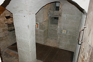
In 1992, during archaeological investigations on the occasion of the renovation of the Bern State Chancellery, the Lenbrunnen in the rear Postgasse 68 was rediscovered. Today parts of the west and south walls are still there up to a height of seven meters. The double-shell walls with a small-grain pebble core consist of sandstone blocks and pebbles with dimensions of around 30 cm and a thickness of 70 to 110 cm. In the water-bearing basement, the bricks are built with probably water-permeable, coarse, low-lime clay mortar.
The well-known geology of the Bern city peninsula - a more permeable silt layer over ice-age, water-bearing moraine gravel - as well as the geologically and hydrologically favorable location of the Lenbrunnen was confirmed by the archaeological investigations. The well tower is dug a little more than four meters into the water-bearing gravel layer on the north side of the peninsula, so that the water could flow into the interior of the well tower.
Based on a resolution by the Bern government council in 1995, the Lenbrunnen facility was preserved and made accessible to the public. Since then, the south side and the inside of the excavated well tower, provided with information boards, a building model and a hydrological model on site, can be visited during the opening hours of the State Chancellery

Glance into the ground floor

Model well tower

Showcase hydrological-geological situation
View into the basement


literature
- Paul Hofer : The art monuments of the canton of Bern. The city of Bern - cityscape · fortifications · city gates · installations · monuments · bridges · city fountains · hospitals · orphanages. Ed .: Society for Swiss Art History (= Die Kunstdenkmäler der Schweiz . Volume 28 ). tape 1 . Birkhäuser Verlag, Basel 1952, Die Stadtbrunnen I. Introduction 2. Groundwater sources, Sodbrunnen., P. 24, 25, 227, and 336 (467 pp., Biblio.unibe.ch [PDF; 68.9 MB ; accessed on March 12, 2018]).
- Berchtold Weber: Historical-topographical lexicon of the city of Bern. Lenbrunnen (places \ Sch \ Schweiz (CH) \ Bern (Kanton) \ Bern (BE) \ L) . Ed .: Burgerbibliothek Bern (= publications of the Berner Burgerbibliothek ). Bern 2016 ( archives-quickaccess.ch [accessed on March 12, 2018]).
- Adriano Boschetti-Maradi, Martin Portmann, Susanne Frey-Kupper : From Lenbrunnen to the State Chancellery: Investigations at Postgasse 68/70 in Bern . In: Education Directorate of the Canton of Bern - Office for Culture (ed.): Archeology in the Canton of Bern: Find reports and essays . tape 5 A. Bern 2004, ISBN 3-907663-00-4 , p. 333–383 (388 pages, e-periodica.ch [accessed on March 12, 2018]).
- Armand Baeriswyl : Sodbrunnen - Stadtbach - Commercial Canal. Water supply and disposal in the city of the Middle Ages and the early modern period using the example of Bern . In: Naturforschende Gesellschaft in Bern (Hrsg.): Communications of the Naturforschende Gesellschaft in Bern . New episode band 69 . Bern August 2012, p. 67–86 ( ngbe.ch [PDF; 745 kB ] Lenbrunnen mentioned on pp. 69–71; Fig. 3 and 4. - PDF for free download).
Web links
- Bern, old town Lenbrunnen. In: erz.be.ch. Education Directorate of the Canton of Bern - Office for Culture, March 6, 2014, accessed on March 26, 2019 .
- Daniel Gutscher, Badri Redha, Eliane Schranz: Bern The Lenbrunnen. (PDF; 1.2 MB) In: erz.be.ch. Education Directorate of the Canton of Bern - Office for Culture, March 10, 2014, p. 4 , accessed on March 26, 2019 (leaflet).
Individual evidence
- ↑ a b Frank Hieronymus: Hans Rudolf Manuel. In: Historical Lexicon of Switzerland . October 27, 2009 , accessed March 12, 2018 .
Coordinates: 46 ° 56 '55.9 " N , 7 ° 27' 10.5" E ; CH1903: 601088 / one hundred ninety-nine thousand seven hundred and fifty-four