
Bern old town
| Old town of Bern | |
|---|---|
|
UNESCO world heritage |
|

|
|
| Aerial view of the old town of Bern |
|
| National territory: |
|
| Type: | Culture |
| Criteria : | (iii) |
| Reference No .: | 267 |
| UNESCO region : | Europe and North America |
| History of enrollment | |
| Enrollment: | 1983 (session 7) |

The old town of Bern is the historic center of the Swiss federal capital Berne and a World Heritage of UNESCO .
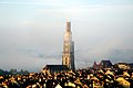
The old town character is best preserved in the area below the Zytglogge (clock tower). The old town is characterized by its sandstone buildings with their arbors , which extend over a length of a good six kilometers and form the longest covered shopping promenade in Europe.
Geographical demarcation

The old town coincides with the 0.85 square kilometer district I, the inner city . These include the statistical districts (including quarters) Yellow Quarters , Green Quarters , Red Quarters , Black Quarters (Matte) and White Quarters . The old town stretches from the top of the Aare loop over the moraine hill westwards to the area of the former entrenchments and ditches.
In the north, east and partly in the south the old town is delimited by the loop of the Aare . In the north is the district V, Breitenrain-Lorraine , in the east, the district IV, Kirchenfeld-Schosshalde . Shortly after the Kirchenfeldbrücke, at Aarestrasse 76, the border runs northwest to the Münzterrasse. Then the border runs along the Münzrain to the Bundeshaus Ost. From there it continues along the Bundeshaus terrace to the Vannazhalde. Then it runs between the Europapromenade and Taubenstrasse to the lower end of the Kleine Schanze , further along Taubenstrasse to the confluence with Bundesgasse . It follows the Hirschengraben to the confluence with the Schanzenstrasse, which it continues to follow, bypasses the Schanzenpost and then follows the park terrace to the Einstein terrace. After a short stretch, the border runs along the bulwark to the Lorraine bridge . There it flows into the Aare.
The modular grid of this river arch city hugs the terrain and expands accordingly in a fan shape towards the west. Spatially, the actual founding city with its expansion stages to the east remained closed. Deep below the point where the longitudinal streets meet, the first fixed crossing was built around 1255 with the Untertorbrücke . It was not until the Nydegg Bridge, completed in 1844, that with its classicist generosity, the spine of the lower town, which ended harmoniously at the old Aare crossing, broke.
Today the old town is connected to the surrounding quarters by the Nydeggbrücke , the Untertorbrücke , the Kirchenfeldbrücke , the Kornhausbrücke , the Altenbergsteg and the Lorrainebrücke .
history
Middle Ages and City Foundation

There is no clear evidence of settlement in the area of today's old town for the early Middle Ages. At the end of the 12th century, today's city of Bern in the knee of the Aare peninsula was founded by Duke Berchthold V von Zähringen , after his predecessor Berchthold IV had already built Nydegg Castle at the tip of the peninsula to protect the Aare crossing there. The Cronica de Berno states 1191 as the year of foundation.
In 1218 the Zähringer family died out and Bern became a royal allod, later an imperial city . As a result, Bern became the largest city-state north of the Alps. Therefore, between 1218 and 1220, the first artificial fortification with a moat, curtain wall and side gate was built. The city gate was the first form of the Zytgloggeturm .
In a chronicle by Conrad Justinger it says: "In the course of the first few decades,« even vil lüten »moved into the city". Therefore, under the protection of the Savoy, an expansion of the urban area up to today's Käfigturm took place from 1255 to 1260 . The predecessor of today's Käfigturm was built in 1256 in the course of the second city fortification on the orders of Peter II as a western defense tower. A new city wall, a defensive tower (today's form Zytglogge) and a city moat were built along the federal, bear and orphanage square. The city was only able to expand in one direction, so the citizens renounced spacious squares and laid out wide market streets, which are characteristic features of all Zähringer cities.
On the occasion of the constitutional reform in 1294, the old town was divided into four quarters. These four quarters were named after the four Venner societies (guilds) that were responsible for their quarters: Pfistern-Viertel, Schmieden-Viertel, Metzgern-Viertel and Gerwern-Viertel. There were two affiliation changes. Once between the third and fourth quarter. The area between Nydeggstalden and today's Nydeggbrücke belonged to the fourth quarter until the end of the 15th century and to the third quarter from the 16th century. In the middle of the 16th century the imbalance of the individual quarters was corrected. This was created by the city's growth, which was almost exclusively westward. Therefore, the border between the quarters was moved from Kreuzgasse to the axis Schaal- and Münstergasse.
The last medieval city enlargement took place from 1344 to 1346. The city area was no longer sufficient in 1350 and it was expanded to the west. The outer Neuenstadt grew between the Käfigturm and the Christoffelturm , which was demolished in 1865 and whose foundations can still be seen today in the train station underpass at the entrance to Spitalgasse . From 1395 onwards, the streets of the city of Bern were paved.
City fire of 1405

When a fire destroyed 52 houses on Junkerngasse on April 28, 1405 , a "bös wip" (New High German: bad woman) from Belpberg predicted further great suffering for the city. This was reported by the town clerk and chronicler Konrad Justinger at the time .
On the afternoon of May 14, 1405, around 4 p.m., a major fire broke out on the south side of Brunngasse . Within a quarter of an hour the whole western Zähringer town was on fire. They say it was a windy day, with a strong breeze blowing from the northeast. Then the fire reached out over the old city moat and, despite attempts to extinguish it, spread over the course of the evening and night to the cage tower. From the burning island monastery , the flames jumped down the slope and laid the Marzili industrial estate to rubble and ashes. Only the Aare was able to stop the fire. The fire destroyed over 600 houses and claimed more than a hundred lives. The cause has never been revealed.
"... So the old kebie burned up, do the zitglogge inside, fountain in it with peacock whores. ... So up to six hundred houses, large and small, and large good in it and me denne a hundred monks. "
“... So the old prison tower, where the Zytglogge hung, burned seven priest whores with it. ... And around 600 houses, large and small, were burned, and they contained many goods and with them more than a hundred people. "
The city leaders ordered the reconstruction out of stone, since then the Bernese sandstone has shaped the cityscape. During the reconstruction after the city fire, construction of the town hall began in 1406 and construction of the Bern Minster in 1421 . Advantages of arcades were discovered and thus the residential and commercial buildings were enlarged and the alleys narrowed. In 1479 the chronicler Albrecht von Bonstetten mentioned : "Alleys that have vaults on both sides, under which you can walk without getting your feet wet".
New establishments

During the Thirty Years' War , from 1622 to 1634 west of the Christoffel Tower, the Small and Large Schanze with several bastions were built as additional fortifications. The resulting space gain was hardly used, instead, the settlement of the existing urban area continued to densify.
In 1640 the first gate of the cage tower was demolished due to dilapidation and replaced from January 1641 to spring 1644 by a new building according to plans by Joseph Plepp . The council, which on May 19, 1638, was in favor of building the new city gate, confirmed its decision on May 29, 1641 and stuck to the old square. The new gate is only 4 meters further west than the original gate.
The new buildings and renovations in the 17th and 18th centuries bear witness to the prosperity of the state and the patrician families. The city was to become a monument and image of the republic. With strict building regulations, the uniform appearance of the city was created, which Johann Wolfgang von Goethe described in 1779 as follows: “It is the most beautiful that we have seen built one like the other in civil equality, all made of grayish soft sandstone, the indifference and cleanliness inside is very good for you, especially since you feel that nothing is empty decoration or the average of despotism, the buildings that the stand of Bern itself erects are large and precious but they have no appearance of splendor that throws one before the other into the eyes [... ] »
Quarters
The church division still valid today goes back to the year 1721, when the parish of Bern was divided. Until then, the Bern Minster was the only parish church. The Nydegg and Heiliggeistkirche were elevated to parish churches in 1721. The parish of Heiliggeist stretches from the Obertor to the Käfigturm, thus encompassing the outer Neustadt. The Münster municipality covers the area from the Käfigturm to the beginning of Gerechtigkeitsgasse . The parish of Nydegg the rest of the lower parish, Nydesggstalden with Altenberg and Schosshalde, Matte and Mattenenge.
In 1798, French troops occupied the city. The division of the old town into five quarters was carried out in 1798 on behalf of the French when they were quartered. The streets were marked with bilingual, German and French-language boards in the appropriate color. The red quarter ranged from Obertor to the Käfigturm, the yellow quarter from the Käfigturm to the Zytgloggeturm, the green quarter from the Zytgloggeturm to Kreuzgasse, the white quarter from Kreuzgasse to Läuferplatz. The mat became black quarters.
Growth and development of the old town


During the 19th century the city began to grow beyond the Aare peninsula, at first only to the west, especially when the city walls and entrenchments fell in the 1830s and the Länggass district was created. Up until now, Bern had only one bridge, the Untertorbrücke , but now it was necessary to build bridges. The first, the Nydeggbrücke , which connects the main level of the old town with the opposite bank of the Aare, was completed in 1844. It was mainly used for traffic and has not yet triggered any major construction activity.
In the middle of the 19th century, new life came to the city as access to the city was made easier. Next to the Untertorbrücke from the 15th century, the Nydeggbrücke was built on the east side between 1840 and 1844. The strictly east-west running city axis was now cut by a north-south connection. By grinding the hill, the Bernese had favorable terrain for the new means of transport, the railway, and in 1858 the first train station was inaugurated.
When, with the construction of the Red Bridge , which was completed in 1858, the railway was brought to today's main station , the Lorraine district was created , where mainly workers' apartments were built. At the end of the 19th century, a phase of urban expansion began, which continues to this day. The condition for this was the construction of bridges, the Kirchenfeldbrücke in the east was built from 1881 to 1883, the Kornhausbrücke from 1895 to 1898. The wealthy residents left the old town, where new working-class quarters emerged. After the completion of the Kirchenfeldbrücke, the Kirchenfeld became the preferred quarter of the wealthy and the foreign representations settled there.
1950 until today
With the resolution of the municipal council of August 8, 1967, the three names Kirchgasse, Münsterplatz and Kesslergasse gave way to the new uniform name Münstergasse on November 1, 1967. With this he took up the name of the minster, which had only been used since the second half of the 19th century.
According to an international convention of 1972, UNESCO maintains a list of cultural and natural objects that are of outstanding importance on a world scale (valeur exceptionnelle universelle). The old town of Bern was included in the UNESCO World Heritage List on the occasion of the World Heritage Committee meeting from December 5 to 9, 1983 in Florence . UNESCO justified the inclusion of Bern on the World Heritage List by saying that, regardless of the changes that the city has undergone since it was founded in the 12th century, “Bern is a positive example of how a city is maintaining its medieval structure and is increasing can adapt to more complex functions that it has to fulfill, especially the tasks of a capital of a modern state ». As the last main street in the lower old town, the Rathausgasse is to be freed of black pavement and paved again by the end of June 2020 .
Neighborhoods and quarters

Historically, the old town is divided into four quarters and four quarters. While the neighborhoods were used for tax and defense purposes, the neighborhoods are the historic districts where citizens of equal social status lived together.
The oldest quarter is the Zähringer town, which contains the most important medieval political , economic and religious buildings. It has existed since the city was founded in 1191.
The second oldest quarter, the Innere Neustadt, was built during the first westward expansion in 1255. The Marktgasse runs through it.
Located in the east, the Nydeggstalden and the Matte district were built together as the smallest district in 1360.
The youngest quarter, the Äussere Neustadt, was built in 1343 and was mainly used for agriculture and animal husbandry .
Others
There is a 20 francs Swiss commemorative “Bern Old Town” coin . The coin is a Memorial Series and the date of issue was June 5, 2003.
“The picture side shows a representation of Bern's old town reduced to the most important contours. The bridges and the cathedral appear particularly striking. The words “BERNER ALTSTADT” are in a line at the top. The center of the value side is dominated by a picture of the upper old town with the clock tower. As on the picture side, the artist has reduced the picture to the most important lines. At the top, parallel to the edge, the word «2003 HELVETIA» can be seen, with the country name being interrupted by the spire. At the bottom is the face value "20 FR" and underneath the mint mark "B". "
| Image side | Value side | year | Physical data | embossed edition | Artist | |
|---|---|---|---|---|---|---|

|

|
2003 |
Alloy : silver-copper (Ag 83.5 / Cu 16.5) Diameter : 33 mm Weight : 20 g |
Unz. 75,000 PP 10,000 |
Franz Fedier , Bern | |
gallery

View into Gerechtigkeitsgasse

Well of Justice
View of the Bern Minster

Child eater fountain

Moses well


literature
- Hermann von Fischer: The preservation of the old town of Bern. For the rally on Münsterplatz in Bern on March 6, 1954 , Munich 1956.
- Jean-Daniel Gross ea: Bern 25 years Unesco World Heritage , Bern 2008.
- Fridolin Limbach: The beautiful city of Bern: d. eventful history d. old "Märit-" or "Meritgasse", d. today's justice u. Kramgasse and the old Zähringer town of Bern; Handdr., Drawing, construction u. House stories, chronicles, old Dr., Bern mandates, government decrees, etc. Kt. Benteli, Bern _381 1978, ISBN 3-7165-0273-1 .
- Dieter Schnell: The old town of Bern becomes a "World Heritage Site" In: Bern's golden age. The 18th century rediscovered, ed. by André Holenstein ea, Bern 2008, p. 26.
- Dieter Schnell: Save the old town! Bern - from renovation to world cultural heritage , Bern 2005.
- Michael Stettler: Interventions in the Bernese cityscape for a hundred years . In: Berner Zeitschrift für Geschichte und Heimatkunde, Vol. 8 (1946), pp. 7ff. doi : 10.5169 / seals-241096
- Michael Stettler and Hermann von Fischer: Vom alten Bern , Genève 1957.
- Berchtold Weber: Streets and their names: using the example of the city of Bern . Stämpfli, Bern 1990, ISBN 3-7272-9850-2 .
See also
Web links
- Homepage of the old town of Bern
- Page no longer available , search in web archives: History of the old town on g26.ch
- "The city fire of 1405" , article in Unipress, publication series of the University of Bern, April 1999
Individual evidence
- ↑ Bern. Bern Tourist Office, accessed on February 17, 2010 .
- ^ Beat Rudolf Tscharner: History of the City of Bern, except for the year 1630 , first part, Bern 1765, p. 2
- ^ Cronica de Berno . In: Gottlieb Studer (ed.): The Berner Chronicle of Conrad Justinger; plus four supplements: 1) Cronica de Berno 2) Conflictus Laupensis 3) The anonymous city chronicle or the Königshofen Justinger 4) Anonymus Friburgensis . Bern 1871 ( digibern.ch [PDF; accessed on May 7, 2009] digital edition 2006).
- ↑ a b c A defense tower becomes a clock tower. Retrieved March 12, 2010 .
- ↑ a b UNESCO and Switzerland: Old Town of Bern. (No longer available online.) Archived from the original on April 12, 2010 ; Retrieved February 18, 2010 .
- ↑ KdKB City of Bern Volume 1 Pages 4–7
- ↑ a b c d e The city fire of 1405. (No longer available online.) In: UNIPRESS - Heft 100. Formerly in the original ; Retrieved February 18, 2010 . ( Page no longer available , search in web archives )
- ^ Zytglogge / city fire. Retrieved February 18, 2010 .
- ↑ Brigitt Sigel: Stadt- und Landmauern , vdf Hochschulverlag AG, 1996, ISBN 978-3-7281-2150-9 , page 66
- ^ Letter (349) Goethe to Frau von Stein from October 9, 1779 in the Gutenberg-DE project
- ↑ Kdm Bern Stadt I, pp. 4–5.
- ^ INSA, p. 249
- ^ Report of the Berner Zeitung
- ^ Beat Junker: Political and structural changes in the city of Bern. In: History of the Canton of Bern since 1798, Volume III: Tradition and Awakening 1881-1995. Historical Association of the Canton of Bern, accessed on May 14, 2009 .
- ↑ The City of Bern - Old Town and UNESCO World Heritage. (No longer available online.) Archived from the original on September 23, 2010 ; Retrieved March 26, 2010 .
- ↑ UNESCO World Heritage Site: Old Town of Bern (1983). Retrieved January 9, 2010 .
- ↑ UNESCO World Heritage Center: Old City of Berne
- ↑ Nomination of the Old City of Berne / Nomination de la cité vielle de Berne. (PDF; 269 kB) International Council on Monuments and Sites , accessed on March 15, 2009 .
- ↑ The paving work begins on Rathausgasse. In: bern.ch. January 8, 2020, accessed January 10, 2020 .
- ↑ a b c Beer, Ellen J .: Bern's great time: the 15th century rediscovered . Berner Lehrmittel- und Medienverlag, Bern 1999, ISBN 3-906721-28-0 ( limited preview in Google book search).
- ↑ a b c d e f The commemorative coin "Bern Old Town" at a glance. (PDF; 429 kB) (No longer available online.) Swissmint, p. 2 , archived from the original on October 29, 2007 ; Retrieved February 17, 2010 .

Cultural heritage: old town of Bern (1983) | St. Gallen Abbey District (1983) | Benedictine convent St. Johann in Müstair (1983) | Three castles and fortifications of Bellinzona (2000) | Lavaux Vineyard Terraces (2007) | Albula and Bernina lines of the Rhaetian Railway (2008) | La Chaux-de-Fonds and Le Locle , watchmaking and urban planning (2009) | Prehistoric pile dwellings around the Alps (2011) | The architectural work of Le Corbusier : Villa Le Lac and Maison Clarté (2016)
Natural heritage: Swiss Alps Jungfrau-Aletsch (2001) | Monte San Giorgio (2003) | Tectonic Arena Sardona (2008)

| Black Quarters (mat) (1) |
Matte (quartier) (101) (identical) |
|
|
White Quarter (2) Green Quarter (3) |
||
|
Yellow Quarters (4) Red Quarters (5) |