Bern-Länggasse
|
Länggasse Statistical district of Bern |
|
|---|---|
| Coordinates | 599868 / 200202 |
| height | 534- 564 m |
| surface | 0.2995 km² |
| Residents | 3227 (2019) |
| Population density | 10'775 inhabitants / km² |
| Proportion of foreigners | 18.3% (2019) |
| Unemployment rate | 2.6% (2016) |
| BFS no. | 351009 |
| Post Code | 3008, 3012 |
| district | Länggasse-Felsenau |
|
Länggasse Common quarter in Bern |
|
|---|---|
| Coordinates | 599306 / 200416 |
| height | 552- 568 m |
| surface | 0.31676 km² |
| Residents | 4847 (2019) |
| Population density | 15,302 inhabitants / km² |
| Proportion of foreigners | 19.5% (2019) |
| Quarter number | 217 |
| Post Code | 3012 |
| Statistical district | Länggasse, Neufeld , Muesmatt , Stadtbach |
| district | Länggasse-Felsenau |
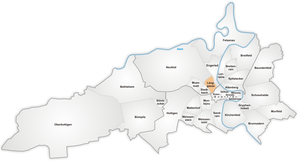
The Länggasse (also: Länggass ) is a quarter and statistical district in the north of the city of Bern .
The name is used both for the smaller statistical district 9 in the district II Länggasse-Felsenau , as well as for a larger common district . The latter is located in four statistical districts: In the north, Länggassstrasse divides the part of statistical district 8 Neufeld from district 11 Muesmatt . In the south, the southern part of the Länggass district belongs to District 10 Stadtbach and the northern part to District 9 Länggasse, which also includes the Alpenegg , Grosse Schanze and southern parts of Brückfeld .
The area on both sides of Länggassstrasse from the train station to Mittelstrasse is also known as “Vordere Länggasse”, while “Hintere Länggasse” extends from Mittelstrasse to Bremgartenwald . Mittelstrasse forms the center of the quarter with various restaurants and shops.
In 2019, the resident population in the statistical district was 3,227, of which 2,638 were Swiss and 589 foreigners. 4847 people live in the usual quarter, of which 3903 are Swiss and 944 are foreigners.
history
The beginnings (until 1850)
Today's Länggass quarter was originally, like most city quarters, an agricultural area. With the construction of the new bridge in 1535, the road leading to Aarberg was laid on the north-eastern periphery of what is now the district area . Also in the 16th century, the Länggasse formed as a dead end to the Bremgartenwald and then as a footpath to the Glasbrunnen, after which the later quarter was to be named. Starting at the end of the 17th century, the first signs of neighborhood development began to emerge along the Länggasse. As early as 1721, the Länggasse was bordered on both sides by small parcels up to the height of today's bus terminus.
In the 18th and early 19th centuries, little changed in the development. The only development was a certain compression of the existing buildings along the long street, which still remained a dead end. This only changed when a connecting road was built that ran along the Bremgartenwald as a promenade. This avenue connected all the country roads on the northwest side of the old town tangentially with one another, from Tiefenaustrasse via Engepromenade and Neubrückstrasse to Murtenstrasse and thus also Länggasse.
The collapse of the Ancien Régime and the turmoil of the political and social reorganization at the beginning of the 19th century initially slowed down all urban development companies. In addition, due to the wave of construction in the 18th century, the need for living space was largely satisfied. The demolition of the fourth western fortification and the entrenchments brought the first urban development impulses . By 1831 practically the entire northern section of the fourth western fortification fell. With the razing of the ski jumps decided in 1834, the history of the modern Länggass district begins.
For the time being, only the eastern edge of the vacated area was built over. From the Heiliggeistkirche to the Schützenmatte, a wide road, the bulwark, will be laid out at the foot of the Grosse Schanze . The Centralbahn was led from the Wylerfeld through the bulwark into the city center, the resulting separation of the Länggass plateau from the old town is completed by the continuation of the railway to the west and the conversion of the terminus to a through station.
The Länggasse becomes an industrial quarter (1850–1890)
In the second half of the 19th century, the machine works Bern (later von Roll) and the Schneider construction business (later Muesmatt carpentry) settled along Bremgartenstrasse. The silk factory between Mittelstrasse and Neufeldstrasse was added around 1865, the Tobler chocolate factory in 1868 and the Stämpfli printing works in 1877. A result of these factory settlements that is still visible today are the workers' settlements created by private consortia and non-profit organizations.
Public buildings and apartment buildings (1890–1915)
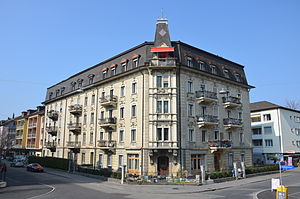
As early as 1876, the office building of the Jura-Simplon-Bahn (today the administrative department of the University of Bern) at Hochschulstrasse 6 came into the quarter as a forerunner of the many service buildings at the turn of the century . In the 1890s a whole series of public buildings followed in quick succession: in 1892 the "New School House" on Neufeldstrasse. 40, 1892–1897 the university buildings at Bühlplatz (anatomy), 1900–1902 the main university building at Hochschulstrasse 4, 1902 the SBB service building at Mittelstrasse 43, 1904/05 the Oberseminar Muesmattstrasse 27 and finally 1901–1905 the Pauluskirche of Freiestrasse 8, one of the main works of Art Nouveau in Switzerland. Towards the end of the century a new type of building appeared in the Länggasse: the upper-class apartment building, such as the Neurokoko-Palast built in 1904 on the corner of Freie- and Muesmattstrasse.
The gaps are filled (1915–1945)
At the beginning of the 20th century, a large part of the Länggasse was still undeveloped, especially parts of the Muesmatt, the Hochfeld and the Brückfeld. By 1940, on the one hand, these gaps will be filled and, on the other hand, the old buildings along the Länggass and Neubrück axes will be replaced. Only a strip of the new field northeast of Länggass-Strasse remains undeveloped.
Compression and displacement (1945–1980)
With the construction of the Hochfeld secondary school (1957), the municipal grammar school Neufeld (1965), the Lindenhof hospital (1965), the animal hospital (1966) and the free grammar school (1972–1973), the Länggasse area is practically completely overbuilt. As a result, densification processes take place throughout the quarter. The original development in the area between Mittelstrasse, Gesellschaftstrasse, Hallerstrasse and Zähringerstrasse will almost completely disappear and will be replaced by new residential buildings.
Refurbishment, conversion, gentrification (1980 to today)
In the most recent phase, the settlement structure of the quarter has remained largely unchanged. The planners have recognized the value of old buildings as witnesses to the urban and industrial history of Bern. Residential houses were renewed or refurbished taking into account the shapes and dimensions customary in the district. Through the conversion of various old industrial buildings, the Länggasse became more and more a university district.
University quarter
When the number of students skyrocketed in the 1960s, the idea of a university campus on the field of four was born . Due to financial bottlenecks and the already visible consequences of the urban sprawl, the project was abandoned. But when the Tobler Chocolatfabrik moved out in 1982, the opportunity arose to buy a large, centrally located property and to convert it to meet the needs of the university. Unitobler was opened in 1993. The old women's hospital on Schanzeneckstrasse (today UniS), the old switch construction hall on the vonRoll site (today lecture hall building) and others followed. Strategy 3012 contains the long-term development goals for the spatial accommodation of the University of Bern and has been included in the cantonal structure plan since 2004.
Residential area
In earlier times, the rear Länggasse was characterized by industrial buildings (Chocolat Tobler and Maschinenfabrik Von Roll) and the associated workers' settlements, but today the whole quarter is mainly a residential area. Many restaurants and shops have settled along the main longitudinal axis, and the students are often a welcome audience. As in Lorraine , tendencies towards gentrification can also be observed in Länggasse .
Other facilities
schools
- Neufeld grammar school
- School district Länggasse (large school building, Hochfeldschulhaus 1, Hochfeldschulhaus 2, Muesmattschulhaus and Türmlischulhaus)
Libraries
- Unitobler basic library
- Library vonRoll
- Länggasse regional library
Churches
Hospitals
Sports facilities
- Neufeld Stadium ( FC Bern , FC Länggasse, Turnverein Länggasse, Gymnastic Society Bern)
literature
- Morgenthaler, Hans: Commemorative publication for the 75th anniversary of the Länggass-Leistes Bern, 1865–1940. Länggass-Leist, Bern 1940 (contains: contributions to the history of the Länggass district ).
- Gerber, Ernst / Furrer, Bernhard: Quartierinventar Länggasse 1988: Municipal inventory according to Art. 75 of the building regulations of the city of Bern from 1981, approved by the municipal council of the city of Bern on March 15, 1989. Monument preservation of the city of Bern, Bern 1989.
- Länggass-Leist and Berner Heimatschutz Regionalgruppe Bern (ed.): The Länggasse: A tour through a Bernese quarter. Haupt-Verlag, Bern 1990.
- Gaberell, Daniel (Ed.): Länggasse. Editor.ch, Bern 2009, ISBN 978-3-9523304-8-7 .
- Furrer, Bernhard: The city of Bern. from the series Swiss Art Guides. Society for Swiss Art History, Bern 1994. ISBN 978-3-85782-553-8 .
- Rupp, Marco: The structural transformation process in the Länggasse: a district analysis Geographical Institute of the University of Bern, Bern 1981.
Web links
- Länggass service Retrieved January 28, 2014 .
- District Commission Bern Länggasse-Felsenau. Retrieved January 28, 2014 .
- Private homepage for the Länggass district. Retrieved January 28, 2014 .
- BVE Kanton Bern ZMB Wyler-Länggasse Report on public participation from December 12, 2018 on bve.be.ch
Individual evidence
- ↑ Interactive city map of the city of Bern (selection under "Topics")
- ↑ Resident population 2019 report p. 5 and 14 on bern.ch
- ↑ Länggass-Leist 1990, p. 12
- ↑ Building inventory of the city of Bern. Preservation of monuments of the city of Bern, 1996, accessed on March 9, 2014 .
- ↑ Rupp (1981)
- ^ The university and its buildings in the federal government from March 27, 2009. Accessed on January 27, 2014
- ^ Unitobler in the architecture guide of the University of Bern . Retrieved January 27, 2014
- ↑ VonRoll University Center. University of Bern, Building and Space Department, accessed on March 15, 2014 .
- ↑ Strategy 3012 of the University of Bern . Retrieved January 27, 2014
- ↑ Measure C 16 in the cantonal structure plan. Retrieved January 27, 2014
- ↑ From the "ghetto" to the trendy district. Berner Zeitung, September 30, 2013, accessed on March 15, 2014 .
- ↑ www.ub.unibe.ch/vonroll , accessed on March 15, 2014


