
Bern-Monbijou
|
Statistical District of Bern |
|
|---|---|
 |
|
| Coordinates | 599651 / 199283 |
| height | 518- 547 m |
| surface | 0.4695 km² |
| Residents | 3352 (2019) |
| Population density | 7140 inhabitants / km² |
| Proportion of foreigners | 22.6% (2019) |
| Unemployment rate | 2.2% (2016) |
| BFS no. | 351015 |
| Post Code | 3007, 3008, 3011 |
| district | Mattenhof-Weissenbühl |
|
Common quarter in Bern |
|
|---|---|
 |
|
| Coordinates | 599690 / 199237 |
| height | 518- 547 m |
| surface | 0.39661 km² |
| Residents | 3105 (2019) |
| Population density | 7829 inhabitants / km² |
| Proportion of foreigners | 22.3% (2019) |
| Quarter number | 302 |
| Post Code | 3007, 3008, 3011 |
| Statistical district | Monbijou |
| district | Mattenhof-Weissenbühl |
The Monbijou is a statistical district (15) and at the same time a smaller common quarter in the III Mattenhof-Weissenbühl district of Bern . In addition to Monbijou, Villette also belongs to the statistical district . It lies between the Hirschengraben in the north and the Sulgenbach in the south. It is surrounded by the Stadtbach district (north), the red district of the old town (east), the Sandrain (southeast), the Weissenbühl in the south and the Mattenhof and Holligen in the west. The Monbijou is 520 to 550 meters above sea level.
In 2019, the statistical district (area of 52 hectares ) has 3352 inhabitants, of which 2596 are Swiss and 756 are foreigners. 3105 inhabitants (2414 Swiss and 691 foreigners) live in the smaller common quarter.
The main traffic axes are the central Monbijoustrasse and the Schwarztorstrasse, which runs in an east-west direction . Eigerstrasse and the subsequent Monbijou bridge also lead to the east in the direction of Kirchenfeld . The district is connected to public transport by Bernmobil lines 9, 10, 19 and 28.
history
The name Monbijou is derived from a former baroque estate that bore the same name. Until the 1840s, the Monbijou was a rural area with estates (Inselscheuer, Besenscheuer, Äusseres Sulgenbachgut, Scheuermattgut etc.), which was crossed by streams. Milling and dyeing works had been located on the Sulgenbach since the Middle Ages and their settlement name was Sulgen . The old Könizstrasse (today Monbijoustrasse and Mühlemattstrasse ) was the most important southern arterial road until 1860 when the Belpstrasse was built. Between the Sulgenbach in the south and the Villette to the north, a loose and inconsistent settlement structure began to emerge around 1850, which still characterizes the quarter today. In 1873 a road network plan for the area was decided.
photos
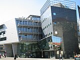
The Titanic II in Bern's Monbijou district

Monbijoustrasse


Web links
Individual evidence
- ↑ Interactive city map of the city of Bern (selection under "Topics")
- ↑ Resident population 2019 (PDF; 4.3 MB) City of Bern, March 2020, pp. 5 and 14 , accessed on March 29, 2020 .
