
Ladder (river)
|
Head of Leiterbach |
||
 Pernhart : View from the Leitertal to the Leiterkees, Adlersruhe and Glockner . |
||
| Data | ||
| location | District Spittal an der Drau , Carinthia and District Lienz , Tyrol | |
| River system | Danube | |
| Drain over | Möll → Drau → Danube → Black Sea | |
| source | arises in the Leitertal as an outflow of the Leiterkeeses | |
| muzzle | At Winkl in the Möll coordinates: 47 ° 3 '14 " N , 12 ° 47' 19" E 47 ° 3 '14 " N , 12 ° 47' 19" E |
|
| Mouth height |
1100 m
|
|
| length | 4.4 km | |
| Catchment area | 20.7 km² | |
| Left tributaries | Hochwartbach, Schwertbach | |
| Right tributaries | Glatzbach, Moosbach | |
.png) Geological map of the Glockner group |
||
The Leiter or the Leiterbach is a right backwater of the Möll . It arises as a glacier stream from the Leiterkees and flows into the Möll just below the Pasterze . Your water is collected for the Kaprun power plant group and channeled over the Tauern main ridge into the catchment area of the Salzach .
The border between Carinthia and East Tyrol runs through the upper part of the Leitertal along the Leiterbach. The lower part of the valley lies entirely in Carinthia. The ladder separates the Glockner group from the Schober group from its origin to the Moosbach . The first ascent of the Großglockner took place via the Leitertal, which is why the Salmhütte is a particularly traditional refuge in the valley . Today the route over the Leitertal to the Glockner is relatively light. On the edge of the Leitertal are on the Berger Törl , the Glorerhütte and, on the Adlersruhe, the Erzherzog-Johann-Hütte .
In the first stanza of the Carinthian Heimatlied , the leader of pure source is mentioned.

View from Bergner Törl ( Glorer Hütte ) to the end of the Leitertal

The ladder fall at the exit of the Leitertal into the Mölltal

The Salmhütte in the Leitertal
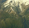
Aerial photo of the Glockner group : the Leitertal to the left of the center of the picture

_Carinthia_Austro-Hungary.jpg)
.JPG)

Individual evidence
- ↑ No title. Google Maps , accessed May 14, 2014 .
- ↑ Leiterbach. Retrieved May 14, 2014 .
- ↑ List of areas of the Austrian river basins - Drau area. Federal Ministry of Agriculture, Forestry, Environment and Water Management , p. 22 , accessed on May 16, 2019 .
- ↑ The hydrological balance 2013 in Carinthia - How is the water balance for Carinthia and individual regions drawn up? Office of the Carinthian Provincial Government - Department 8 - Competence Center Environment, Water and Nature Conservation, accessed on May 14, 2014 .
- ^ Glockner group. Bergverlag Rudolf Rother , accessed on May 14, 2014 .
- ↑ Eastern Alps. (No longer available online.) Archived from the original on January 8, 2015 ; accessed on May 14, 2014 . Info: The archive link was inserted automatically and has not yet been checked. Please check the original and archive link according to the instructions and then remove this notice.