Lekeitio
| Lekeitio municipality | ||
|---|---|---|
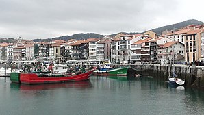
 The port of Lekeitio
|
||
| coat of arms | Map of Spain | |

|
|
|
| Basic data | ||
| Autonomous Community : |
|
|
| Province : | Bizkaia | |
| Comarca : | Lea-Artibai | |
| Coordinates | 43 ° 22 ′ N , 2 ° 30 ′ W | |
| Area : | 1.9 km² | |
| Residents : | 7,307 (Jan 1, 2019) | |
| Population density : | 3,845.79 inhabitants / km² | |
| Postal code : | 48280 | |
| Municipality number ( INE ): | 48057 | |
Lekeitio (Spanish Lequeitio ) is a municipality in the Spanish Basque Country , province of Bizkaia . The town with 7307 inhabitants (as of 2019) is located at the confluence of the Lea in the Biscay .
geography
Geographically, Lekeitio is bounded by the Atlantic (in the north and east), the Lea (in the east) and the 115 m high Lumentza mountain (in the south-east). The island of Garraitz, northeast of the port, belongs to the municipality . Garraitz (also called San Nicolás or Lumencha) is uninhabited today and can be reached on foot at low tide. The Armintxe cave , in which cave paintings were found, is located under the built-up area .
Politically, the densely populated urban area (3846 inhabitants / km²) is delimited by the sparsely populated neighboring communities Mendexa (in the east) and Ispaster (in the south and west). Larger cities nearby are Gernika (15 km to the southwest) and Ondarroa (8 km to the southeast).
Facilities and buildings
The place has a port, a sandy beach Isuntza and a basilica ( Basilica Santa Maria ).
Personalities
- Resurrección María de Azkue (1864–1951), priest, linguist, writer, musician.
Footnotes
- ↑ Cifras oficiales de población resultantes de la revisión del Padrón municipal a 1 de enero . Population statistics from the Instituto Nacional de Estadística (population update).
- ↑ https://www.luftlinie.org/Lekeitio/Gernika
- ↑ https://www.luftlinie.org/Lekeitio/Ondarroa,Provincia-de-Vizcaya,Basque-Country,ESP
