Basauri
| Basauri municipality | ||
|---|---|---|
 Basauri (2003)
|
||
| coat of arms | Map of Spain | |

|
|
|
| Basic data | ||
| Autonomous Community : |
|
|
| Province : | Bizkaia | |
| Comarca : | Bilbao | |
| Coordinates | 43 ° 14 ′ N , 2 ° 53 ′ W | |
| Height : | 64 msnm | |
| Area : | 7.01 km² | |
| Residents : | 40,589 (Jan 1, 2019) | |
| Population density : | 5,790.16 inhabitants / km² | |
| Founding: | 1510 | |
| Postal code : | 48970 | |
| Municipality number ( INE ): | 48015 | |
| administration | ||
| Website : | Basauri | |
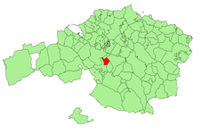
| Location of the municipality | ||

|
||
Basauri is a city in the province of Bizkaia in the Basque Country Autonomous Community in northern Spain.
location
Basauri is located in the metropolitan area of the greater Bilbao area , in a small river plain at the confluence of the two most important rivers of the province of Biscay, the Nervión and the Ibaizabal . The streets of Orduña and Durango , which follow the course of the two rivers , also meet in Basauri . A district takes its name from the fork in both roads: Bidebieta (two roads). From the river basin where the municipality originated, the land gradually rises to the southwest to the Malmasín mountain (361 m), which rises between Basauri, Arrigorriaga and Bilbao.
history
Basauri appears as an independent political entity at the beginning of the 16th century. Until then, the place was part of the municipality of Arrigorriaga. With the construction of the Church of San Miguel de Basauri from 1510 onwards, its own community was formed. Basauri was only represented in the General Assembly of Guernica from 1858 .
In the second half of the 19th century, Basauri was the largest town in the area and its administrative center. In 1902 a new town hall was built in the neighboring village of Arizgoiti immediately to the north. Because Arizgoiti grew faster than the old village of Basauri and was also more central, namely equidistant from the two outermost points of the municipality: San Miguel de Finaga , a former hermitage , in the south and El Boquete (Zubialdea) in the north. Today Arizgoiti is one of the districts of Basauri and its town center.
Basauri was a predominantly rural area until the end of the 19th century, until the time when the metalworking factory Basconia was founded and with it the industrialization of the city began. In 50 years the population increased from a few thousand to 55,000 in 1978. Families from all regions of Spain have expanded Basauri and radically changed its urbanity.
population
| 1900 | 1910 | 1920 | 1930 | 1940 | 1950 | 1960 | 1970 |
| 1,989 | 3,456 | 5,194 | 9,444 | 10,405 | 11,626 | 22,991 | 41,558 |
| 1980 | 1990 | 2000 | 2001 | 2003 | 2007 | 2009 | 2012 |
| 55,648 | 50,940 | 47,376 | 46,669 | 45,346 | 43,250 | 42,657 | 42,971 |
Web links
Individual evidence
- ↑ Cifras oficiales de población resultantes de la revisión del Padrón municipal a 1 de enero . Population statistics from the Instituto Nacional de Estadística (population update).
- ↑ Aspectos socio-politicos de la historia de Basauri ( Memento from August 21, 2016 in the Internet Archive )
- ↑ La Basconia ( Memento from August 21, 2016 in the Internet Archive )
