
Leonrodplatz (Munich)
| Leonrodplatz | |
|---|---|
|
|
|
 Leonrodplatz (seen from the corner of Dachauer Strasse and Schwere-Reiter-Strasse ) |
|
| Basic data | |
| State capital | Munich |
| Borough | Neuhausen |
| Created | 1906 |
| Confluent streets | Dachauer Strasse , Leonrodstrasse, Schwere-Reiter-Strasse , Dom-Pedro-Strasse |
| use | |
| User groups | Pedestrian traffic , bicycle traffic , individual traffic , public transport |
The Leonrodplatz is a place in the Munich district Neuhausen . It was named in 1927 after the former Bavarian Minister of Justice Leopold von Leonrod .
description
Leonrodplatz is at the intersection of Dachauer Straße with Leonrodstraße and Schwere-Reiter-Straße or Dom-Pedro-Straße. The Olympic Park joins in the northeast .
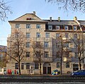
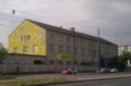
To the west, Leonrodplatz is closed around the beginning of Dom-Pedro-Straße and is lined with listed buildings from the beginning of the 20th century. To the north, Leonrodplatz will border the 39,000 square meter seven-story building of the criminal justice center , which has been under construction there since 2016 on a major construction site in which the Free State of Bavaria is investing 300 million euros and which is due to move into in 2021. To the east has been the Pathos Transport Theater since 1982 and the Schwere-Reiter-Theater since 1993 and the Theater Werk München on Leonrodplatz since 2011 , as well as the Munich Center of Community Arts (MUCCA). In the future, the Schwabing creative quarter will be built here , according to the Süddeutscher Zeitung, “the liveliest and most diverse artist biotope” in Munich. In the south are post-war buildings with retail stores , which were the filming location for the crime scene The Truth in May 2016 .
The tram lines from Hohenzollernplatz to Rotkreuzplatz and those from Stiglmaierplatz to Westfriedhof and on to Moosach cross at Leonrodplatz .
In March 2017, the Neuhausen-Nymphenburg district committee decided to convert Leonrodplatz into a district center through a design competition. The planned construction of a mosque for 800 prayers with a 20 meter high dome and 30 meter high minaret on Leonrodplatz, behind which Imam Benjamin Idriz and the Munich Forum for Islam (MFI) stood , will not be realized .
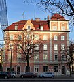
German Renaissance corner building built in 1908 by R. Barbist at Leonrodplatz (Leonrodstraße 91)

Art Nouveau corner building from the beginning of the 20th century on Leonrodplatz (Dom-Pedro-Straße 1)

Rounded Art Nouveau corner building from the beginning of the 20th century on Leonrodplatz (Dom-Pedro-Straße 2)
historicizing corner building from the beginning of the 20th century on Leonrodplatz (Dachauer Straße 185)
Heavy rider theater on Leonrodplatz


-2014-06-13.png)
history

.jpg)
The area around today's Leonrodplatz was completely undeveloped until the middle of the 19th century. The barracks district of Munich later developed around today's Leonrodplatz. South of today's Leonrodplatz was the Maximilian II barracks from 1877 as the largest barracks ever built in Munich , which was destroyed in World War II. The railway barracks were built north of today's Leonrodplatz in 1890, and the new criminal justice center has been in this area since 2016. During the construction of the justice center, a 1,200-square-meter underground structure was found that was 80 meters long and 15 meters wide at a depth of up to five meters and was filled with scrap iron after the Americans took quarters in 1945 . The artillery workshops have been located east of today's Leonrodplatz since the end of the 19th century , further to the east the airship barracks ( Luitpoldkaserne ) were built in 1896 south of today's Schwere-Reiter-Straße and expanded in 1935 to include the barracks in Oberwiesenfeld . In 1926 the barrel and jute halls were built on this corner, the area on the corner of Schwere-Reiter-Straße, Leonrodplatz and Dachauer Straße u. a. used by Stadtwerke München . As the successor to the police driving school, the volunteer fire brigade used a considerable part of the premises from 1995 to May 2016 . From 2000 to 2003 the Kammerspiele Munich played in the Jutierhalle on Leonrodplatz.
In 1883 the first Munich steam tram drove from today's Stiglmaierplatz to Nymphenburg, which was then outside of the city. As the trains frightened the horses on Nymphenburger Strasse due to the noise , the line was moved to less busy parallel streets . The new tram connection from Stiglmaierplatz to Leonrodplatz was used for the first time on July 25, 1909. In 1928 the tram lines followed from Hohenzollernplatz to Rotkreuzplatz, in 1930 the line was extended from Stiglmaierplatz to Moosacher Bahnhof .
For the 1972 Olympic Games , a car bridge was built over the Leonrodplatz along Dachauer Strasse , which was demolished again in the early 1990s.
Individual evidence
- ^ Hans Dollinger: The Munich street names. 3. Edition. Ludwig Verlag, Munich 1997, ISBN 3-517-01986-0 , p. 175.
- ↑ a b Finds of poison delay the new judicial building on Leonrodplatz In: tz 23 May 2016
- ^ Christian Rost: Justice. Where justice will be spoken in Munich in the future. Süddeutsche Zeitung . November 25, 2015, accessed April 13, 2016.
- ^ Institute for Applied Cultural Education
- ^ A biotope for artists In: Süddeutsche Zeitung January 11, 2016
- ↑ Jonas Erlenkämper: Munich “Tatort” is a highlight by Batic and Leitmayr In: Westdeutsche Allgemeine Zeitung October 23, 2016
- ↑ Leonrodplatz: The intersection should become a square In: tz March 7, 2017
- ^ Nina Bovensiepen : Plans for Islam Center in Munich failed In: Süddeutsche Zeitung June 28, 2016
- ^ " KulturGeschichtsPfad Neuhausen-Nymphenburg" , City of Munich.
- ↑ Munich im Kaiserreich ( Memento of the original from November 4, 2004 in the Internet Archive ) Info: The archive link was inserted automatically and has not yet been checked. Please check the original and archive link according to the instructions and then remove this notice. in: The history of Munich . Retrieved April 13, 2016.
- ↑ Michael Schattenhofer (Ed.): 100 Years of Munich Tram , Munich City Archives, 1976, p. 28f.
- ^ Beauty cure for Leonrodplatz In: Süddeutsche Zeitung March 1, 2017
Coordinates: 48 ° 9 ′ 33.8 ″ N , 11 ° 32 ′ 49.2 ″ E