Liao He
|
Liao He 辽河 |
||
|
The Liao He river system |
||
| Data | ||
| location | Liaoning ( PR China ) | |
| River system | Liao He | |
| Confluence of |
Xiliao He and Dongliao He near the municipality of Guyushu 42 ° 58 ′ 53 ″ N , 123 ° 32 ′ 50 ″ E |
|
| muzzle | in Yingkou in the Liaodong Bay of the Gulf of Bohai Coordinates: 40 ° 54 ′ 42 " N , 121 ° 48 ′ 42" E 40 ° 54 ′ 42 " N , 121 ° 48 ′ 42" E |
|
| Mouth height |
0 m
|
|
| length | 1390 km | |
| Left tributaries | Hun He , Taizi He | |
| Right tributaries | Liu He (Liao He) | |
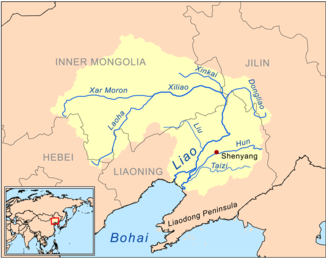
The Liao He , Liao River , Liauho , etc. ( Chinese 遼河 / 辽河 , Pinyin Liáo Hé , W.-G. Liao Ho , English Liao River ) is the largest river in southern northeast China ( Manchuria ) with a length of 1390 km .
The names of Liaoning Province and the Liaodong Peninsula are derived from him. The Liao He is formed by the union of the rivers Xiliao He ( 西 遼河 / 西 辽河 , Xīliáo Hé - "Western Liao River") and Dongliao He ( 東 遼河 / 东 辽河 , Dōngliáo Hé - "Eastern Liao River").
The eastern Dongliao He rises in the hill country Jilin Hada Ling ( 吉林哈達 嶺 / 吉林哈达 岭 , Jílín Hādá Lǐng ) in Dongliao County of Jilin Province . The western Xiliao He is in turn formed by the union of the northern flowing Xar Moron He ( 西拉 木 倫 河 / 西拉 木 伦 河 , Xīlā Mùlún Hé ) and the Laoha He ( 老 哈 河 , Lǎohā Hé ) from the south. A later tributary of the Xiliao He is the Xinkai He ( 新開河 / 新开河 , Xīnkāi Hé ).
The Xar Moron He rises in the Baicha Shan Mountains ( 白 岔 山 , Báichà Shān ) in the southwest of the witches' banner in southeastern Inner Mongolia . The Laoha He rises in the Guangtou Shan ( 光頭 山 / 光头 山 , Guāngtóu Shān ) of the Pingquan County in Hebei Province .
The two rivers unite near the area of the large municipality of Guyushu ( 古 榆树 镇 , Gǔyúshù zhèn ) of Changtu County in Liaoning, and from there the river flows under the name Liao He through the great Liaohe Plain into Liaodong Bay (Liaodong Wan ) of the Gulf of Bohai (Bo Hai).
In 1958 the river changed its course.
See also
literature
- Cihai. Shanghai cishu chubanshe, Shanghai 2002, ISBN 7-5326-0839-5
