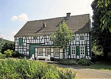
Lindenhof (Oberelfringhausen)
The Lindenhof is a historic farm on Felderbachstraße 91 in the Hattingen district of Oberelfringhausen ( North Rhine-Westphalia ). The half-timbered house, a listed building since 1983, was built around 1780.
history
The Lindenhof was first mentioned in a document in 1005 as "Diie Lynde, up ter Lynden" . According to the wisdom of 1534, Herman up der Liinden was one of the 19 free royal farmers of the Hattingen court. His court was one of the three with the highest taxes. He had to give in money and in kind : Maibede 22 Croner (Deutzer) Albus , Herbstbede 27 Albus - Offergelt ( tithe ) 9 Albus - dog oats 2 Malter - to the abbot 1 bushel of oats , 1 pig "from 8 daler" and 1 man's schilling the mayor 1 bushel of oats, 1 mowing service and the case tax (death tax).
The Lindenhof used to have a number of Kotten , such as the "Buschmannskotten", the Kotten "Im Stemmen", the Kotten "Unterste Höbusch", the Kotten "Herolds Egge", the Kotten "Hildebrandts Egge" and the Kotten "Jost am Hippenhorn" in Oberstüter , which were lost in the 19th century through marriage or sale. The original size of the Kotten property must have been well over 200 acres . After the Kotten left, the Lindenhof is still 144 acres in size and stretches from the border of the Bärwinkel farmstead over the Felderbachstrasse, the so-called Linnerkopp (Linderkopf, Linderhöhe) - where the Fliehburg used to be and now the Barmen radio beacon is - over the Höhenweg to the Deilbach . There is also a stream meadow that belongs to the farm.
In addition to the half-timbered house, a separate farm workers' house from the 19th century also belonged to the Lindenhof. Formerly with band knitting , from 1936 rented to the Winkelmann family. Until 1959, the coppersmith and sculptor Wilhelm Winkelmann (1904–1989) ran a workshop and studio here. During the Second World War with billeted soldiers and the radio center for the Felderbachtal . At the end of the 1960s, agriculture was given up on the Lindenhof. During this time the farm workers' house was torn down and a modern house was built on the same spot.
The owners had been the Lindermann family, named after the Lindenhof, from time immemorial until they passed the farm to the businessman Emil Ströter senior in 1919. from Barmen , who sold it to his son Emil Ströter jun. rented. In 1925 the Lindenhof was acquired by the Meiwes family from Meiderich . This had to leave its traditional yard there because the Duisburg inland port was being expanded. Heinrich Meiwes was 1,952 to 1,969 community leaders from top Elfring Hausen. Due to the marriage of their daughter Ute, the next generation of the Pohlmann family now lives on the Lindenhof.
The Lindenhof is located in the Niederbredenscheid / Elfringhausen landscape protection area and a hornbeam is a natural monument to the south of the half-timbered house .
Fliehburg
On the western base of the Lindenhofes, the Linder head ( caulking ), the remains of a 23-acre old Germanic centrifugal or was during excavations in the 1930s Wallenburg discovered with a double rampart. Presumably the outer wall was 2 m high and the inner wall 1 m high in its original state and in between was the impenetrable thorny undergrowth. They also found an approx. 4000 year old stone weapon, a hand ax made of greenish stone that was easily worked. Today, the BAM “Barmen” rotating radio beacon is located on the site of the former ramparts, and the outer rampart can only be guessed at some of the surrounding field borders.
See also
Web links
Individual evidence
- ^ Heinrich Eversberg : The medieval Hattingen , cultural history and settlement geography of a city on the Ruhr - Ed .: Heimat- und Geschichtsverein Hattingen eV 1985, pp. 44, 55, 343
- ↑ Michael Winkelmann: Design and free art as a life's work - Wilhelm, Michael and Christoph Winkelmann (1927–2017) , pdf [1]
- ^ Wilhelm Ophüls: Alt-Langenberg - A home book . Verlag Hermann 1936 (hand ax in the exhibition "Langenberg Local History Collection")
- ↑ Citizens, Local History and Tourist Association Elfringhausen and the surrounding area (ed.): From Wagnes (primeval) forest to Elfringhauser Switzerland - On the trail of the past - Part I - About the old Germanic peoples - About the original settlement in the hill country - About the Courtyards from 1005 to the present day. In: Elfringhauser Heimatschriften , 1999, Volume 6, pp. 26, 51-52 pdf [2]
Coordinates: 51 ° 19 ′ 41.9 ″ N , 7 ° 10 ′ 58.1 ″ E

