List of cultural monuments in Bitburg
The list of cultural monuments in Bitburg includes all the cultural monuments of the Rhineland-Palatinate city of Bitburg, including the districts of Erdorf , Irsch , Masholder , Matzen , Mötsch and Stahl . The basis is the list of monuments of the state of Rhineland-Palatinate (as of May 17, 2018).
Bitburg
Monument zones
| designation | location | Construction year | description | image |
|---|---|---|---|---|
| Monument zone Franz-Mecker-Straße | Franz-Mecker-Strasse 3/5, 7, 9, 11, 13 location |
between 1903 and 1913 | Single and semi-detached houses in a villa-like garden location opposite the city park, late historicism, Heimatstil and reform architecture, between 1903 and 1913 |
 more pictures more pictures
|
| Barracks monument zone | Mötscher Strasse location |
1936-38 | 1936–38 built barracks (pioneers, military hospital) around the central parade ground, with team accommodations, two casinos, gym, workshop building, garages, guard pavilion, three-storey brick buildings with windowed sand-lime brick facades, sand-lime stone enclosure |
 more pictures more pictures
|
| Monument zone Pützhöhe | north of the city on the L 32 location |
from 1893 | Group of houses based on a farmstead laid out in 1860 and destroyed in World War II, preserved: distillery, marked 1899, by Richard Luhn, Haspe in Westphalia; Chapel of the Holy Family, two-tone sandstone block, 1893, in the gable an older former wayside cross; Villa, reform architecture, 1913 by Anton Köster, garage and barn, 1924 |
 more pictures more pictures
|
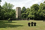
| Monument zone Ehrenfriedhof Kolmeshöhe | southwest of the city location |
from 1912 | Sand-lime brick tower, 1912, increased when included in the war memorial built in 1930 and the portal changed; after 1945 conversion to the cemetery of honor: lawn surrounded by linden trees with sandstone name boards and groups of sandstone crosses, sandstone stations of the cross |
 more pictures more pictures
|
Individual monuments
| designation | location | Construction year | description | image |
|---|---|---|---|---|
| city wall |
location |
from the 4th century | Remains of the Roman (4th century) and the medieval city wall built on it at Murengasse, on the Roman wall below the town hall and rectory, in the gable of the house at Hans-Lehnert-Gasse 10, behind the western development Im Graben, in the cul-de-sac, in Gable of Petersstraße 34 and on the south side Im Kobenhof; In the Middle Ages, the city was expanded to the south: medieval wall sections of the city expansion along the west side of the Denkmalstrasse at the level of the memorial, above No. 5 and at the confluence of the Schliezgasse |
 more pictures more pictures
|
| facade | Adrigstrasse 17 location |
Mid 18th century | two-axis facade with a baroque portal, mid-18th century |
 more pictures more pictures
|
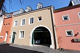
| barn | Adrigstrasse 22 location |
first half of the 19th century | Barn, sandstone-framed limestone building, first half of the 19th century |
 more pictures more pictures
|
| villa | At the market 4 location |
around 1930 | Villa, hipped mansard roof with two-storey loggia, around 1930 |
 more pictures more pictures
|
| Wayside cross | On Paulskreuz, at No. 2 position |
after 1807 | Shank cross, rococo motifs, after 1807 |
 more pictures more pictures
|
| Residential building | Bergstrasse 1a location |
around 1820 | Sophisticated residential building, cubic mansard hipped roof, around 1820 |
 more pictures more pictures
|
| Villa Limbourg | Denkmalstrasse 6 location |
around 1900 | Late historical sandstone-integrated sandstone block building, extended and rebuilt around 1900 |
 more pictures more pictures
|
| graveyard | Erdorfer Straße / Talweg location |
before 1808 | laid out before 1808, oldest tombstone: Grabmal J. and E. Holzemer († 1824 and 1808); Tomb L. Kunkol († 1895), sandstone plinth, cast iron inscription plaque and cross; elaborate tomb of the Niederprüm family, around 1900; Tomb Th. Simon († 1910), artificial stone; Fallen grave of E. Soomann († 1915); Grave of the Görgen family, grieving youth, around 1918; Cemetery cross, marked 1863; at the southern exit there are Jewish grave monuments, mostly obelisks |
 more pictures more pictures
|
| Residential building | Franz-Mecker-Strasse 5 location |
1906 | historic house with rich half-timbered construction, 1906 |
 more pictures more pictures
|
| Residential building | Franz-Mecker-Strasse 7 location |
1903 | Sophisticated house, late historical and Heimatstil motifs, 1903 |
 more pictures more pictures
|
| Residential building | Franz-Mecker-Strasse 13 location |
1909 | Semi-detached house, late historical and Art Nouveau motifs as well as the influence of reform architecture, inscribed 1909 |
 more pictures more pictures
|
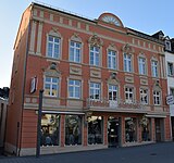
| Hotel Zur Post | Hauptstrasse 6 location |
1802 | former "Zur Post" hotel; seven-axis plastered building, 1802, second floor and baroque facade decoration probably younger |
 more pictures more pictures
|
| facade | Main street, at No. 11 location |
19th century | Residential and commercial building with a sophisticated late classicist red sandstone cuboid facade, 19th century |
 more pictures more pictures
|
| Residential houses | In trench 8, 10 location |
delightful group of two lower stable houses |
 more pictures more pictures
|
|
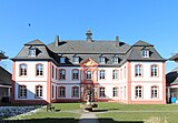
| St. Martin School | Koelner Strasse 14 location |
1764 | so-called castle ; Sandstone-integrated three-wing building with a mansard hipped roof, marked 1764 (chronogram), restored after being destroyed in the war in 1957–59 |
 more pictures more pictures
|
| Residential building | Kölner Strasse 17 location |
1897 | late historic house, nine renaissance motifs, marked 1897 |
 more pictures more pictures
|
| villa | Kölner Strasse 39 location |
1910 | Villa, late historical brick building, 1910 |
 more pictures more pictures
|
| Residential building | Mötscher Strasse 10 location |
1909 | Residential house, mansard roof with crested, intermediate and foot hip, Art Nouveau motifs, 1909 |
 more pictures more pictures
|
| Eifel hosiery factory | Mötscher Strasse 14 location |
after 1912 | former "Eifel hosiery factory"; Large three-storey plastered building, baroque motifs and reform architecture, shortly after 1912 |
 more pictures more pictures
|
| Catholic Parish Church of St. Peter | Prelate-Benz-Strasse location |
1956-58 | Rectangular hall with side aisle, baptistery, bell tower, limestone blocks, 1956–58, architect Hans Geimer , Bitburg, colored glazing by Rudi Schilling , bronze doors with relief 1980 by Johann Baptist Lenz ; defining the townscape |
 more pictures more pictures
|
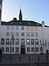
| town hall | Rathausplatz 4 location |
1953-55 | four-storey hipped roof building, tower-like extension on the remains of a city wall tower, 1953–55, architect Otto Vogel , Trier, extension 1986/87, architects Ilse and Bert Emmerich |
 more pictures more pictures
|
| Old rectory | Rathausplatz 5 location |
1889/90 | Entrance side and east axis, red sandstone cuboid, apsidal extension on the remains of a city wall tower, 1889/90, reconstruction changed after it was destroyed in the war; neo-Gothic sandstone sculpture |
 more pictures more pictures
|
| Catholic parish church of Liebfrauen | Rathausplatz 8 location |
14th or 15th century | in the core a late Gothic hall, extension to a three-aisled hall with west tower 1860, architect Alexander Franz Himpler , vertical, baroque extension, 1922/23, architect Eduard Endler , Cologne; in the corner between the old building and the extension baroque portal, 1751; with equipment |
 more pictures more pictures
|
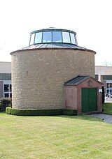
| Deep well house | Roman wall without number location |
1936 | Deep well house of the Th. Simon brewery ; cylindrical sand-lime brick building, flat dome with pent roof, 1936, architect Heinrich Bartmann , Darmstadt |
 more pictures more pictures
|
| Spolia of the Cobentower | Roman wall without number, in the entrance area of the town hall / Bitburger brand adventure world location |
1576 | Spolia of the frieze from the so-called Cobenturm, two relief panels, two consoles, four small bases, metope, inscription panel inscribed 1576 (renovation); further spoils in the town hall and in the district museum Bitburg-Prüm |
 more pictures more pictures
|
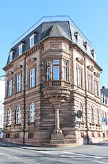
| Residential building | Roman wall 1 layer |
1887 | representative corner house, neo-renaissance building, 1887 |
 more pictures more pictures
|
| Residential building | Roman wall, to No. 1 position |
1740 | Former residential building, baroque plastered building with a protruding staircase, marked 1740 |
 more pictures more pictures
|
| Gas station | Saarstrasse 20 location |
1954 | Gas station; two halls with curved open roofs, front tank room with flat ceiling, 1954; defining the streetscape |
 more pictures more pictures
|
| Residential building | Schakengasse 12 location |
Mid 18th century | stately former residential building, baroque mansard roof, mid-18th century |
 more pictures more pictures
|
| District administration | Trierer Strasse 1 location |
1905/06 | former district building; monumental, late-historical plastered building, bay tower with neo-renaissance and baroque motifs, 1905/06, rebuilt in simplified form after partial destruction in 1944/45 |
 more pictures more pictures
|
| gym | Trierer Strasse 11 location |
1906 | former gym; Elaborate late-historic building, cladding made of limestone blocks and red sandstone, marked 1906 |
 more pictures more pictures
|
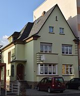
| Residential building | Trierer Strasse 14 location |
1930 | Plastered building on partially storey-high limestone cuboid plinth, 1930, architect Anton Köster, Bitburg |
 more pictures more pictures
|
| Bitburg-Prüm District Museum | Trierer Strasse 15 location |
1882 | former agricultural school; representative building with red sandstone facade, three-storey gable elevation, 1882, architects A. Krone and PJJ Wolff, 1928 rear extension, reform architecture |
 more pictures more pictures
|
| Evangelical parish church | Trierer Strasse 17 location |
1950/52 | Red sandstone block construction, choir tower with tent roof, the rectory with a perpendicular plastered building, 1950/52, architect Otto Vogel |
 more pictures more pictures
|
| Residential and commercial building | Trierer Straße 26/28 location |
before 1914 | Three-storey double residential and commercial building, motifs from historicism, Art Nouveau and reform architecture, before 1914 |
 more pictures more pictures
|
| Wayside cross | east of the city location |
1778 | Wayside cross; Red sandstone, marked 1778 |
 more pictures more pictures
|
| Castle mill | west of the city (An der Stadtmühle 10) location |
1821 | former mill; large-volume cripple-hip roof building, marked 1821, water wheel, oven; former spinning mill, 1923 |
 more pictures more pictures
|
| Courtyard | west of the city (An der Stadtmühle 13) location |
in the middle of the 19th century | Streckhof, plastered building, middle of the 19th century, increased in 1898 |
 more pictures more pictures
|
Erdorf
Individual monuments
| designation | location | Construction year | description | image |
|---|---|---|---|---|
| Courtyard | Am Kyllpesch 3 location |
second half of the 18th century | former hall kitchen house, remodeled after the middle of the 18th century, in the second half of the 19th century; late baroque outbuilding, marked 1769 |
 more pictures more pictures
|
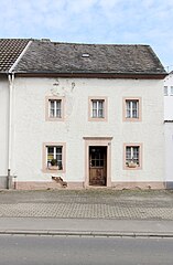
| Residential building | Bonner Strasse 28 location |
1834 | three-axle house, marked 1834 |
 more pictures more pictures
|
| Wayside cross | Bonner Strasse, at No. 49 location |
14th or 15th century | Late Gothic niche cross in relief |
 more pictures more pictures
|
| Wayside cross | Bonner Strasse, corner of Mainzer Strasse Lage |
14th or 15th century | Fragment of a late Gothic niche cross |
 more pictures more pictures
|
| War memorial | Bonner Strasse, corner of Raiffeisenstrasse Lage |
1813 | Former cemetery cross as the center of a war memorial 1914/18 and 1939/45, shaft cross with relief of St. Nicholas and crucifixion group, marked 1813 and 1926 (conversion) |
 more pictures more pictures
|
| Wayside cross | Kylltalweg, opposite No. 2 location |
1663 | Wayside cross; Shaft with relief, inscribed 1663, top cross probably younger |
 more pictures more pictures
|
| Courtyard | Laurentiusstrasse 6 location |
1872 | Streckhof, Scheune marked 1872; Economy annex marked 1890 |
 more pictures more pictures
|
| Catholic parish church of St. Laurentius | Mainzer Strasse location |
1896/97 | neo-Gothic red sandstone block with transept, 1896/97, architect Reinhold Wirtz , master builder of the cathedral , Trier; with equipment |
 more pictures more pictures
|
| Railway maintenance | Mainzer Straße 6a location |
1871 | Eifelbahn station mastery , small red sandstone building, 1871 |
 more pictures more pictures
|
| Erdorf station | Mainzer Strasse 12 location |
1871 | Erdorf station of the Eifelbahn; Entrance building, picturesque red sandstone building, partly half-timbered, 1871 |
 more pictures more pictures
|
| Mill | Mühlenstrasse 4/5 location |
1763 | former mill; Three-sided courtyard; Residential house, marked 1763, former farm building, stables and barn, second farm building, mill building, mid-19th century |
 more pictures more pictures
|
| Crosses | north of the village, on the cemetery (Bonner Straße) location |
from 1642 | Cross, neo-Gothic, towards the end of the 19th century, as a crucifixion group supplemented by earthenware figures on priestly graves from 1922 and 1924; Way cross fragment, upper part of the shaft, marked 1642 |
 more pictures more pictures
|
| Maria-Hilf chapel | north of the village (Kapellenstrasse) location |
1868 | small plastered building, 1868; Starting from Kyllburger Strasse 14 stations of the cross to the chapel, cast iron panels on a sandstone shaft |
 more pictures more pictures
|
| Wayside cross | northeast of the town of Lage |
first half of the 17th century | Niche cross, first half of the 17th century, new niche roof and crucifix |
 more pictures more pictures
|
| Railway bridge | south of the village location |
1915 | Railway bridge of the Nimstalbahn over the Kyll between route kilometers 0 and 1; Part of the railway line from Bitburg-Erdorf to Irrel, which was completed by 1915 |
 more pictures more pictures
|
| North portal of the Mettericher tunnel | south of the village location |
around 1870 | North portal of the Metterich tunnel of the Eifelbahn between route kilometers 133 and 134, with battlements and side turrets, around 1870 | |
| chapel | south of the village on the K 87 location |
1872 | Chapel; Plaster construction, 1872; in front of the chapel shaft of a late Gothic cross |
 more pictures more pictures
|
Irsch
Monument zones
| designation | location | Construction year | description | image |
|---|---|---|---|---|
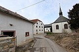
| Monument zone in the center of Irsch | Irscher Hof location |
18th century | Hamlet that has developed from two farmsteads and a chapel since the beginning of the 18th century, including the surrounding meadows with limestone walls and the cemetery |
 more pictures more pictures
|
Individual monuments
| designation | location | Construction year | description | image |
|---|---|---|---|---|
| Courtyard | Irscher Hof 1 location |
1751 | Winkelhof ; three-axle house, marked 1751, extension with a former blacksmith's shop, backs, barn and stables, outermost marked 1785 |
 more pictures more pictures
|
| Courtyard | Irscher Hof 2 location |
first half of the 18th century | Residential house, first half of the 18th century, utility wing marked 1728, heightened floor after 1945, two barns, marked 1812 and 1858, gate marked 1865; Outbuilding with bakery, mid-19th century; belonging to the court chapel of St. John the Evangelist |
 more pictures more pictures
|
| Court chapel of St. John the Evangelist | Irscher Hof, to No. 2 location |
1827 | Tent roof construction, marked 1827; with equipment |
 more pictures more pictures
|
| Railway bridge | east of the village location |
1915 | Railway bridge of the Nimstalbahn; Part of the railway line from Bitburg-Erdorf to Irrel, which was completed by 1915 |
 more pictures more pictures
|
Masholder
Monument zones
| designation | location | Construction year | description | image |
|---|---|---|---|---|
| Monument zone in the center of Masholder | Burengasse, Im Wingert, Tannenstrasse, Zur Heide location |
18th and 19th centuries | Core of the clustered village made up of courtyards from the middle of the 18th and 19th centuries, including a church and churchyard |
 more pictures more pictures
|
Individual monuments
| designation | location | Construction year | description | image |
|---|---|---|---|---|
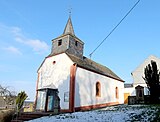
| Catholic branch church of St. Firminus, Quirinus and Ferrucius | Burengasse location |
1808 | Saalbau, marked 1808; with equipment; Churchyard with family graves, late 19th and first half of the 20th century; late historical tomb of the T. Neyses family; in the staircase upstream there is a capital, 18th century, and an Ecce Homo bust |
 more pictures more pictures
|
| Residential building | Burengasse 1 location |
Mid 18th century | large-volume baroque house, mid-18th century |
 more pictures more pictures
|
| Residential building | Burengasse 2 location |
1813 | House with stepped gables, marked 1813 |
 more pictures more pictures
|
| Courtyard | In Wingert 9 location |
1740 | Streuhof; Stately dwelling house with knee stick, economic part marked 1740, living part marked 1785, sheepfold |
 more pictures more pictures
|
| Courtyard | In Wingert 11 location |
1788 | Winkelhof ; Residential house and lower farm wing, marked 1788, farm building probably from the beginning of the 19th century, stables and two barns from the beginning of the 20th century |
 more pictures more pictures
|
| Wayside cross | Tannenstrasse, opposite No. 8 location |
1739 | Way cross, red sandstone, marked 1739 |
 more pictures more pictures
|
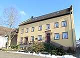
| Courtyard | Tannenstrasse 11 location |
1798 | Winkelhof ; House with stepped gables, marked 1798; defining the townscape |
 more pictures more pictures
|
| Wayside cross | To the heath, opposite No. 6 location |
1634 | Shank cross, red sandstone, marked 1634; cast iron crucifix younger |
 more pictures more pictures
|
| Wayside cross | east of the village location |
1867 | Memorial cross, marked 1867 |
 more pictures more pictures
|
Matzo
Monument zones
| designation | location | Construction year | description | image |
|---|---|---|---|---|
| Monument zone Donatusstraße | Donatusstrasse 6, 11, 13, 14, 16 location |
18th and 19th centuries | Part of the upper village of Matzen, group of farmhouses that have been preserved almost undisturbed, 18th and 19th centuries |
 more pictures more pictures
|
Individual monuments
| designation | location | Construction year | description | image |
|---|---|---|---|---|
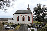
| Catholic branch church St. Donatus | Donatusstrasse location |
1816 | Hall building, late baroque and neo-Gothic motifs, 1816; Neo-Gothic cemetery cross extended to become a war memorial, 1887 |
 more pictures more pictures
|
| Residential building | Donatusstrasse 6 location |
1844 | Five-axis dwelling house with knee floor, marked 1844 and 1807 |
 more pictures more pictures
|
| Courtyard | Donatusstrasse 8 location |
1742 | elongated Winkelhof ; House marked 1742, more recent extension, stable wing, farm building from the last quarter of the 19th century, dry stone wall |
 more pictures more pictures
|
| Cross house | Donatusstrasse 11 location |
1750 | Quereinhaus, marked 1750, extension marked 1810, shed and pigsty |
 more pictures more pictures
|
| Residential building | Donatusstrasse 16 location |
1785 | House, 1785 |
 more pictures more pictures
|
| Wayside cross | Lerchenstrasse location |
1809 | Shank cross, marked 1809 |
 more pictures more pictures
|
| portal | Lerchenstraße, at No. 17 Lage |
1868 | Portal, lintel marked 1868, door leaf and skylight neo-Gothic |
 more pictures more pictures
|
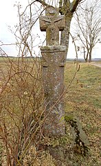
| Wayside cross | east of the village location |
1600 | Wayside cross; Shaft, marked 1600, top cross younger |
 more pictures more pictures
|
| Wayside cross | south of the village on the B 51 location |
first half of the 17th century | Niche cross, first half of the 17th century |
 more pictures more pictures
|
| Wayside cross | south of the village location |
Way cross, inscribed 1653, top cross probably younger |
 more pictures more pictures
|
Mötsch
Individual monuments
| designation | location | Construction year | description | image |
|---|---|---|---|---|
| school | At the sports field 2 location |
1911 | former school and teacher's apartment; Plastered building, reform architecture, 1911, outbuildings partly half-timbered |
 more pictures more pictures
|
| Memorial cross | Bitburger Strasse location |
1867 | Memorial cross, neo-Gothic, 1867 |
 more pictures more pictures
|
| War memorial | Bitburger Strasse, at No. 2 location |
around 1900 | War memorials 1870/71; neo-Gothic memorial cross |
 more pictures more pictures
|
| Wayside cross | Bitburger Strasse 2 location |
14th or 15th century | Ways cross fragment; late Gothic shaft |
 more pictures more pictures
|
| Courtyard | Bitburger Strasse 12 location |
1855 | Streckhof; House marked 1855, economic section marked 1895, older house with a sloping roof, first half of the 18th century, economy marked 1902 |
 more pictures more pictures
|
| Residential building | Bitburger Strasse 14 location |
1791 | three-axle house, bakery extension, portal walls, allegedly offset, marked 1791; together with no. 12 defining the townscape |
 more pictures more pictures
|
| portal | Bitburger Strasse, at No. 18 location |
1794 | Skylight portal, stylized plant motifs, marked 1794 |
 more pictures more pictures
|
| Wayside cross | Bitburger Strasse, at No. 18 location |
after 1750 | three-part shaft cross, red sandstone, after 1750 |
 more pictures more pictures
|
| barn | Bitburger Strasse 26 location |
17th century | former stable, 17th century |
 more pictures more pictures
|
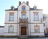
| Gasthaus Schröder | Bitburger Strasse 27 location |
1908 | Late historical plastered building, neo-renaissance motifs, 1908 |
 more pictures more pictures
|
| Wayside cross | Hüttinger Strasse, in front of No. 29a Lage |
1729 | baroque shaft, marked 1729, historicist grave cross |
 more pictures more pictures
|
| Catholic parish church of St. Nicholas | Ringstrasse location |
1786 | medieval west tower, nave marked 1786, transept with crossing tower 1922/23, architect Eduard Endler, Cologne; the former south portal today memorial; Epitaph, red sandstone, marked 1600, successor to the Trier sculpture school of Hans Ruprecht Hoffmann ; Churchyard Cross, 1873 |
 more pictures more pictures
|
| Courtyard | Ringstrasse 4 location |
1765 | Streckhof, marked 1765, remodeling after the middle of the 19th century, barn, probably a former tithe barn from 1875 |
 more pictures more pictures
|
| Farm buildings | Ringstrasse 20 location |
1875 | large-volume farm building with hipped roof, marked 1875 (?) |
 more pictures more pictures
|
| Wayside cross | northwest of the village location |
first quarter of the 19th century | Wayside cross; Shaft, first quarter of the 19th century, new final cross |
 more pictures more pictures
|
| Wayside cross | northwest of the village location |
1809 | Shank cross, marked 1809 |
 more pictures more pictures
|
| Wayside cross | southeast of the location |
1857 | Shank cross, marked 1857, top cross with cast iron body |
 more pictures more pictures
|
| Lady Chapel | southeast of the place (Heinrich-Hertz-Straße) location |
1890 | Limestone building, 1890 |
 more pictures more pictures
|
steel
Individual monuments
| designation | location | Construction year | description | image |
|---|---|---|---|---|
| Wayside cross | In the Nistal, at No. 17 Lage |
1637 | Shank cross, formerly probably marked 1637, the relieved foot of the top cross marked 1762 |
 more pictures more pictures
|
| Parish hall | Neuenweg 1 location |
1911 | former school; cubic mansard hipped roof, 1911; defining the townscape |
 more pictures more pictures
|
| Wayside cross | Neuenweg, in front of No. 1 location |
late 17th century | Shank cross, probably from the late 17th century |
 more pictures more pictures
|
| Wayside cross | Oberweiser Strasse location |
1760 | Shank cross, marked 1760 |
 more pictures more pictures
|
| Courtyard | Oberweiser Strasse 2 location |
1738 | Winkelhof ; Residential house, marked 1738, in the core probably older, barn with stepped gable, marked 1836, Remise, residential house (former farm), second half of the 19th century; defining the townscape |
 more pictures more pictures
|
| Courtyard | Oberweiser Straße 5 location |
1722 | stately Winkelhof ; House with stepped gables, marked 1785 and 1722, lower stables, farm building with oven |
 more pictures more pictures
|
| Catholic branch church St. Wolfgang and Luzia | Oberweiser Straße 11 location |
1426 | Hall building, marked 1752, in the core possibly from 1426 |
 more pictures more pictures
|
| Spolia | Oberweiser Straße, at No. 24 Lage |
1738 | Baroque portal, marked 1738; door lintel in relief, marked 1628; Segmented arched window, 18th century |
 more pictures more pictures
|
| Mill | Oberweiser Straße, to No. 28 location |
1798 | Mill; Putzbau, marked 1798; Overall system with arch and waterfront structure of the trench |
 more pictures more pictures
|
| Cemetery cross | Stahler Weg, on the cemetery location |
historicist cemetery cross, baroque artificial stone body, probably from the beginning of the 1890s; Extension with two memorial plaques for the fallen after 1945 |
 more pictures more pictures
|
|
| Baking mill | south of the village location |
1847 | Seven-axle residential building, marked 1847, large-volume farm building, marked 1856, enclosing walls of the economic wing, wooden shed |
 more pictures more pictures
|
literature
- Ernst Wackenroder (arr.): The art monuments of the Bitburg district (= Paul Clemen [Hrsg.]: The art monuments of the Rhine province . Volume 12 / I ). Trier 1983, ISBN 3-88915-006-3 (315; pages = 45-68 (Bitburg city), 65 (Irsch), 66-67 (Mötsch), 67-69 (steel), 92-93 (Erdorf), With 12 plates and 227 illustrations in the text. Reprinted by the Schwann edition, Düsseldorf 1927).
- Bernd Altmann, Hans Caspary: Bitburg-Prüm district. City of Bitburg, Verbandsgemeinden Bitburg-Land and Irrel (= cultural monuments in Rhineland-Palatinate. Monument topography Federal Republic of Germany . Volume 9.2 ). Wernersche Verlagsgesellschaft, Worms 1997, ISBN 3-88462-132-7 .
- General Directorate for Cultural Heritage Rhineland-Palatinate (Ed.): Informational directory of the cultural monuments in the Eifel district of Bitburg-Prüm (PDF; 4.4 MB). Mainz 2018.
Individual evidence
- ^ Entry on Liebfrauen (Catholic parish church) in the database of cultural assets in the Trier region ; accessed on March 1, 2016.
Web links
Commons : Kulturdenkmäler in Bitburg - Collection of pictures, videos and audio files