Little Auglaize River
| Little Auglaize River | ||
|
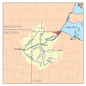
Map of the Little Auglaize River within the Maumee River Basin. |
||
| Data | ||
| Water code | US : 1066072 | |
| location | Ohio (USA) | |
| River system | Saint Lawrence River | |
| Drain over | Auglaize River → Maumee River → Niagara River → Saint Lawrence River → Atlantic Ocean | |
| source | 8 km northeast of Rockford, OH 40 ° 43 ′ 48 " N , 84 ° 33 ′ 46" W |
|
| Source height | 242 m | |
| muzzle | Auglaize River, north of Melrose, OH Coordinates: 41 ° 6 ′ 42 " N , 84 ° 24 ′ 55" W, 41 ° 6 ′ 42 " N , 84 ° 24 ′ 55" W |
|
| Mouth height | 210 m | |
| Height difference | 32 m | |
| Bottom slope | 0.67 ‰ | |
| length | 48 km | |
The Little Auglaize River is a 30 miles long left tributary of the Auglaize River in the northwest of the US state Ohio and belongs to the river system of the Saint Lawrence River .
The river rises about five miles northeast of the town of Rockford in southern Van Wert County , Ohio, flowing first in a north-northeast and then generally north through Counties Van Wert, Putnam, and Paulding . It flows 4 km north of the village of Melrose in eastern Paulding County into the Auglaize River.
Web links
Individual evidence
- ↑ a b Google Earth altitude for GNIS coordinates, accessed on August 2, 2010.
- ↑ Little Auglaize River in the Geographic Names Information System of the United States Geological Survey
- ↑ Little Auglaize River
