Auglaize River
| Auglaize River | ||
|
Auglaize River east of Junction |
||
| Data | ||
| Water code | US : 1065901 | |
| location | Ohio (USA) | |
| River system | Saint Lawrence River | |
| Drain over | Maumee River → Niagara River → Saint Lawrence River → Atlantic Ocean | |
| origin | 3.2 km south of Harrod 40 ° 40 ′ 53 ″ N , 83 ° 55 ′ 16 ″ W |
|
| Source height | 302 m | |
| muzzle | Maumee River at Defiance Coordinates: 41 ° 16 ′ 48 ″ N , 84 ° 22 ′ 0 ″ W 41 ° 16 ′ 48 ″ N , 84 ° 22 ′ 0 ″ W. |
|
| Mouth height | 203 m | |
| Height difference | 99 m | |
| Bottom slope | 0.62 ‰ | |
| length | 160 km | |
| Catchment area | 6053 km² | |
| Left tributaries | Little Auglaize River, Flatrock Creek | |
| Right tributaries | Ottawa River, Blanchard River | |
|
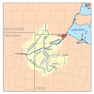
Map of the Auglaize River within the Maumee River basin. |
||
The Auglaize River is a right tributary of the Maumee River in the northwest of the US state Ohio .
The catchment area of the 160 km long river consists mainly of arable land. The name of the river comes either from the Shawnee language and means felled trees or from the French expression for frozen water .
The Auglaize River rises in southeast Allen County about 15 km south of Lima and 20 km north of Indian Lake. It first flows southwest to Wapakoneta, then generally zigzagging north and passing the towns of Delphos, Fort Jennings and Oakwood. At Defiance it flows into the Maumee River, which flows in a north-easterly direction at Toledo into Lake Erie . Tributaries of the Auglaize are the Ottawa River and the Blanchard River from the right , and the Little Auglaize River and Flatrock Creek from the left .
In the 18th century at the time of the so-called Ohio area , the catchment area of the river was inhabited by the Ottawa . Fort Defiance was built in August 1794 by order of General Anthony Wayne at the confluence of the Auglaize in the Maumee River. It was the last in a series of fortifications built by American forces during the Northwest Indian War. Fort Amanda dates from the War of 1812 and was built on the Auglaize River southwest of the city of Lima . During the war it served mainly as a supply base.
Name variants
The river has several designations:
- Au Glaize River
- Auglaise River
- Glaize River
- Grand Au Glaze River
- Grand Glaise River
- Grand Glaize River
- Great au Glaise River
- Qusquasrundee
Web links
Individual evidence
- ↑ a b Google Earth altitude for GNIS coordinates, accessed on July 23, 2010.
- ^ Auglaize River in the Geographic Names Information System of the United States Geological Survey
- ^ Smith, Thomas H. The Mapping of Ohio . Kent, Ohio: Kent State University Press, 1977. p155
- ^ Doctor HF Raup Ohio Place Names Research File
- ^ Bauman, Robert F. When the Maumee Was Called the Tawa . Northwest Ohio Quarterly, v.28 (Spring, 1956) pp.60-87. p71
- ^ Bauman, Robert F. When the Maumee Was Called the Tawa . Northwest Ohio Quarterly, v.28 (Spring, 1956) pp.60-87. p72
- ^ Bauman, Robert F. When the Maumee Was Called the Tawa . Northwest Ohio Quarterly, v.28 (Spring, 1956) pp.60-87. p74
- ^ Bauman, Robert F. When the Maumee Was Called the Tawa . Northwest Ohio Quarterly, v.28 (Spring, 1956) pp.60-87. p75
- ^ Smith, Thomas H. The Mapping of Ohio . Kent, Ohio: Kent State University Press, 1977. p154
- ↑ GeoNative. Accessed from www.geocities.com/Athens/9479. Useful for names in minority languages. Details includes date accessed. Wyandot / Sep 18, 2001

