Ottawa River (Auglaize River)
| Ottawa River | ||
|
|
||
| Data | ||
| Water code | US : 1070882 | |
| location | Ohio (USA) | |
| River system | Saint Lawrence River | |
| Drain over | Auglaize River → Maumee River → Niagara River → Saint Lawrence River → Atlantic Ocean | |
| origin | 1.5 km north of Lafayette, OH; Confluence of Hog Creek and Little Hog Creek 40 ° 46 ′ 15 ″ N , 83 ° 57 ′ 21 ″ W |
|
| Source height | 273 m | |
| muzzle | Auglaize River, 6 km northwest of Kalida, OH Coordinates: 40 ° 59 ′ 42 " N , 84 ° 14 ′ 29" W, 40 ° 59 ′ 42 " N , 84 ° 14 ′ 29" W |
|
| Mouth height | 214 m | |
| Height difference | 59 m | |
| Bottom slope | 0.74 ‰ | |
| length | 80 km | |
| Catchment area | 945 km² | |
| Big cities | Lima (Ohio) | |
|
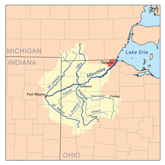
Location of the Ottawa River within the Maumee River basin |
||
The Ottawa River is a 80 km long right tributary of the Auglaize River and flows through the northwestern part of the state of Ohio in the USA .
It is one of two rivers named " Ottawa River " in northwest Ohio, along with the Ottawa River from Toledo , which flows into Lake Erie .
The Ottawa River is part of the Saint Lawrence River system . The river is created about 1.5 km north of the town of Lafayette in southern Allen County by the confluence of Hog Creek and Little Hog Creek. The river is named after the Ottawa Indian people who settled in this region in the 18th century. The Ottawa River flows first northwest, then west-southwest through the city of Lima . About 3 km southeast of Lima, the river turns abruptly north, flows through western Putnam County, and joins the Auglaize River about 5 km northwest of Kalida .
The catchment area covers around 945 km², 69% of which is arable land and pastures, 7% is forest and the rest is urbanized or used for other purposes. The area spans Hardin , Allen and Putnam Counties ; the biggest cities are Lima and Fort Shawnee . According to the Geographic Names Information System (GNIS), the river is also referred to as Hog River, Kashko Sepe, Ottawa Creek and similar spellings.
The Ottawa River also bears the local name "Hog Creek" (German: Schweinbach ). This name goes back to the following story:
"Alexander McKee, the British Indian Agent, who resided at the Machachac towns, on Mad River, during the incursion of General Logan from Kentucky in 1786, was obliged to flee with his effects. He had a large lot of swine, which were driven on to the borders of this stream, and when the Indians (Shawnee) came on they called the river Koshko Sepe, which in the Shawnee language signed 'The Creek of the Hogs, or Hog Stream'. "
" Alexander McKee was the British Indian Commissioner for the Machachac Settlements on the Mad River. During the invasion of Kentucky by General Logan in 1786, McKee had to flee with all his belongings. He owned a large herd of pigs that belonged to When the Shawnee Indians saw this, they called the river "Koshko Sepe", which in the Shawnee language means something like "The brook of pigs" or "brook of pigs".
Web links
Individual evidence
- ↑ a b Google Earth altitude for GNIS coordinates, accessed on August 2, 2010.
- ↑ a b c Ottawa River (Auglaize River) in the Geographic Names Information System of the United States Geological Survey
- ^ Ottawa River (Auglaize River) in the Geographic Names Information System of the United States Geological Survey
- ^ Ottawa River (Auglaize River) in the Geographic Names Information System of the United States Geological Survey
- ^ RH Harrison: Atlas of Allen County, Ohio from Records and Original Surveys . RH Harrison, Philadelphia 1880, p. 36.
