Maumee River
| Maumee River | ||
|
Veterans' Glass City Skyway in Toledo on the Maumee River |
||
| Data | ||
| Water code | US : 1084017 | |
| location | Indiana , Ohio (USA) | |
| River system | Saint Lawrence River | |
| Drain over | Niagara River → Saint Lawrence River → Atlantic Ocean | |
| confluence | St. Joseph and St. Marys River 41 ° 5 ′ 0 ″ N , 85 ° 7 ′ 56 ″ W. |
|
| Source height | 229 m | |
| muzzle | Lake Erie coordinates: 41 ° 41 ′ 58 " N , 83 ° 27 ′ 36" W 41 ° 41 ′ 58 " N , 83 ° 27 ′ 36" W. |
|
| Mouth height | 174 m | |
| Height difference | 55 m | |
| Bottom slope | 0.26 ‰ | |
| length | 209 km | |
| Catchment area | 16,458 km² | |
| Drain |
MQ |
150 m³ / s |
| Big cities | Toledo , Fort Wayne | |
|
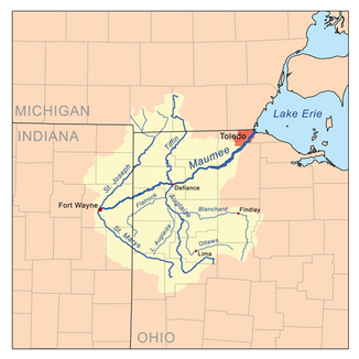
The catchment area of the Maumee River |
||
The Maumee River is a river in the northwestern US state of Ohio and is formed near Fort Wayne from the confluence of the St. Joseph River and St. Marys River .
It meanders northeast through an agricultural region and flows after 209 km into the Maumee Bay of Lake Erie near the city of Toledo . The Maumee River received the Ohio State Scenic River rating on July 18, 1974 and is therefore considered a river under the protection of the state of Ohio.
The former name of the river was Miami River and in treaties with the Indians it was referred to in 1671 as Miami of the Lakes or in French as Miami du Lac . The Battle of Fallen Timbers , the final battle of the Northwest Indian War , was fought around 1 km north of the Maumee River. After General Anthony Wayne's victory over the Indians in 1795, they had to cede the entire catchment area of the river to the Americans, which at that time was called the Great Black Swamp (Great Black Swamp). The swamp was later drained and turned into fertile farmland. A piece of the wetlands in the estuary has been the nature reserve, recreation and vacation area of Maumee Bay State Park since 1975 .
With 16,458 km², the Maumee River has the largest catchment area of all rivers that flow into the Great Lakes . In addition to its two headwaters, the St. Joseph and St. Marys Rivers, the Auglaize River from the south and the Tiffin River from the north are two of the most important tributaries that both flow into the Maumee River at Defiance .
Noteworthy is the annual migration of the Walleye up the Maumee River, considered one of the largest fish migrations east of the Mississippi . The migration of the perch usually begins in early March and lasts until the end of April, while the climax is expected in the first week of April.
Web links
Individual evidence
- ↑ a b Google Earth altitude for GNIS coordinates, accessed on July 23, 2010.
- ↑ a b Maumee River in the Geographic Names Information System of the United States Geological Survey
- ↑ a b c Maumee River. Retrieved July 23, 2010 .
- ↑ Walleye Hike. Retrieved July 23, 2010 .

