St. Joseph River (Maumee River)
| St. Joseph River | ||
|
St. Joseph River in Fort Wayne, Indiana |
||
| Data | ||
| Water code | US : 1624891 | |
| location | Indiana , Ohio , Michigan | |
| River system | Saint Lawrence River | |
| Drain over | Maumee River → Niagara River → Saint Lawrence River → Atlantic Ocean | |
| confluence | from West Branch and East Branch St. Joseph River about 6 miles southwest of the village of Pioneer in northern Williams County, OH 41 ° 38 ′ 54 ″ N , 84 ° 33 ′ 55 ″ W |
|
| Source height | 261 m | |
| Union | with the St. Marys River near Fort Wayne to the Maumee River Coordinates: 41 ° 4 ′ 59 " N , 85 ° 7 ′ 55" W 41 ° 4 ′ 59 " N , 85 ° 7 ′ 55" W |
|
| Mouth height | 230 m | |
| Height difference | 31 m | |
| Bottom slope | 0.19 ‰ | |
| length | 160 km | |
| Catchment area | 2808 km² | |
|
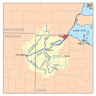
St. Joseph River in the Maumee River Basin |
||
The St. Joseph River is a roughly 160 km long tributary of the Maumee River in the US states of Indiana , Ohio and Michigan .
At the confluence with the St. Marys River , it forms the Maumee River in Fort Wayne , which is part of the river system of the Saint Lawrence River. The catchment area, including the two headwaters and the numerous tributaries, covers 2,808 km² (694,000 acres) and extends over a total of eight counties . The St. Joseph River is formed in northern Williams County by the confluence of the West Branch and East Branch St. Joseph River . It then flows generally in a south-southwest direction through the counties Williams and Defiance in Ohio, as well as through the counties DeKalb and Allen in Indiana, to the union with the St. Marys River in the city of Fort Wayne.
The catchment area is mainly used for agriculture. Approximately 64% consists of arable land, 15% are pastures, 10% are forest or wetlands, and the remaining 11% are urbanized or otherwise used. The topography of the area varies between hilly terrain in the north and the middle of the river and almost flat terrain in the south. The St. Joseph River follows the Fort Wayne moraine and has washed away countless low cliffs and terraces.
Web links
Individual evidence
- ↑ a b Google Earth altitude for GNIS coordinates, accessed on July 30, 2010.
- ↑ a b St. Joseph River (Maumee River) in the Geographic Names Information System of the United States Geological Survey
- ↑ a b St. Joseph Watershed ( Memento of the original from May 15, 2010 in the Internet Archive ) Info: The archive link was inserted automatically and has not yet been checked. Please check the original and archive link according to the instructions and then remove this notice.

